
EAW014219 ENGLAND (1948) [Unlocated]. UNLOCATED
© Copyright OpenStreetMap contributors and licensed by the OpenStreetMap Foundation. 2024. Cartography is licensed as CC BY-SA.
Nearby Images (48)
EPW000143

EPW000667

EPW005260

EPW006389
, 1921")
EPW007181

EPW015853

EPW015854

EPW015855

EPW016012

EPW016510

EPW016641

EPW017028

EPW017029

EPW017136

SAW003585

SAW003586

SAW009337

SAW009800

SAW009801

SAW009802

SAW010734

SAW014737

SAW017926

SAW017927

SAW032504

SPW020275

SPW020280

SPW020281

SPW020284

SPW020632

SPW020633

SPW027083

SPW049776

SPW049777

SPW049779

SPW049783

SPW049791

SPW049798

SPW049801

SPW049827

SPW049828

SPW049831

SPW049832

SPW049834

SPW049948

SPW049949

SPW051009

SPW062638

Details
| Title | [EAW014219] UNLOCATED |
| Reference | EAW014219 |
| Date | 9-April-1948 |
| Link | |
| Place name | |
| Parish | |
| District | |
| Country | ENGLAND |
| Easting / Northing | 0, 0 |
| Longitude / Latitude | -7.556448482059, 49.766185796754 |
| National Grid Reference | SV000000 |
Pins
 Andrew Bennett |
Monday 31st of March 2014 10:58:08 PM | |
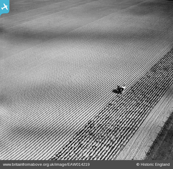
But, Andrew, that is how Agriculture was .... things took a long time and huge amounts of human effort and hard physical labour. The horse naturally did not tread on the potato rows (ridges) and the wheels of the cart fitted into the 'valleys'. The resulting small amounts of soil compaction was away from the crop. The horse would occasional add a little manure to the process and a little methane to the atmosphere. The hard work was poorly paid and sometimes partly in payment in kind - a sack of potatoes or the use of tided house. If you lost your job or became unable to work you probably lost your home as well. The field appears to have been plough and planted by tractor pulled machine. The flatness suggests The Fens, but the manure suggests a location with a more mixed farming pattern, having been produced by animals elsewhere on the enterprise. That muck is still being spread suggests this farm had not yet taken up the use of inorganic industrially produced fertilisers. It was organic farming before "organic farming" became an issue! |
 Maurice |
Tuesday 1st of April 2014 07:02:01 AM |
User Comment Contributions
EAW014217 is of Agricultural lime laying, Meriden, 1948 taken on 9th April 1948. |
 Class31 |
Tuesday 4th of February 2014 01:35:53 PM |