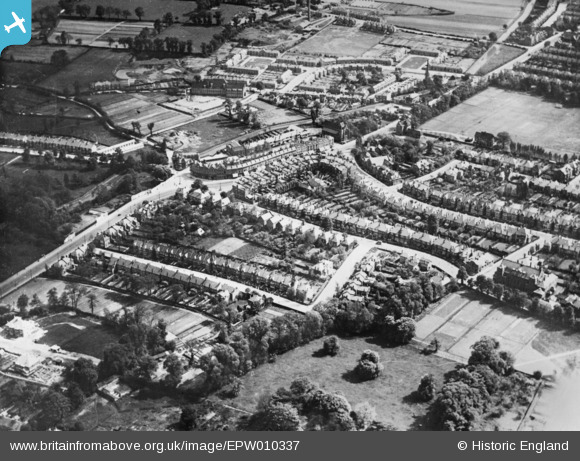
EPW010337 ENGLAND (1924). Station Road and Green Lane, Winchmore Hill, 1924. This image has been produced from a copy-negative.
© Copyright OpenStreetMap contributors and licensed by the OpenStreetMap Foundation. 2024. Cartography is licensed as CC BY-SA.
Details
| Title | [EPW010337] Station Road and Green Lane, Winchmore Hill, 1924. This image has been produced from a copy-negative. |
| Reference | EPW010337 |
| Date | April-1924 |
| Link | |
| Place name | WINCHMORE HILL |
| Parish | |
| District | |
| Country | ENGLAND |
| Easting / Northing | 531824, 194328 |
| Longitude / Latitude | -0.095104221280779, 51.631829551927 |
| National Grid Reference | TQ318943 |
Pins
 Downloader141 |
Saturday 23rd of September 2023 09:45:18 AM | |
 Mickeygo |
Saturday 10th of July 2021 06:34:52 PM | |
 Kam |
Saturday 27th of June 2020 06:46:31 AM | |
 Mickeygo |
Saturday 25th of January 2020 06:59:41 PM | |
 Mickeygo |
Sunday 12th of January 2020 08:12:01 PM | |
 Mickeygo |
Tuesday 7th of January 2020 10:50:46 AM | |
 Mickeygo |
Sunday 5th of January 2020 10:09:40 PM | |
 Mickeygo |
Sunday 5th of January 2020 10:05:33 PM | |
 Mickeygo |
Sunday 5th of January 2020 10:03:45 PM | |
 Mickeygo |
Sunday 5th of January 2020 08:32:31 PM | |
 Mickeygo |
Sunday 5th of January 2020 08:31:16 PM | |
 Mickeygo |
Sunday 5th of January 2020 08:28:13 PM | |
 BHP-Paul |
Friday 8th of July 2016 09:05:11 PM | |
 BHP-Paul |
Friday 8th of July 2016 09:04:22 PM | |
 BHP-Paul |
Friday 8th of July 2016 09:03:28 PM |


