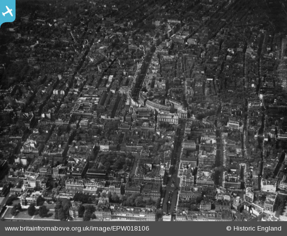
EPW018106 ENGLAND (1927). Regent Street and environs, Westminster, 1927. This image has been produced from a print.
© Copyright OpenStreetMap contributors and licensed by the OpenStreetMap Foundation. 2024. Cartography is licensed as CC BY-SA.
Nearby Images (48)
Details
| Title | [EPW018106] Regent Street and environs, Westminster, 1927. This image has been produced from a print. |
| Reference | EPW018106 |
| Date | May-1927 |
| Link | |
| Place name | WESTMINSTER |
| Parish | |
| District | |
| Country | ENGLAND |
| Easting / Northing | 529415, 180608 |
| Longitude / Latitude | -0.13494934306635, 51.509078859528 |
| National Grid Reference | TQ294806 |
Pins
Be the first to add a comment to this image!


![[EPW018106] Regent Street and environs, Westminster, 1927. This image has been produced from a print.](http://britainfromabove.org.uk/sites/all/libraries/aerofilms-images/public/100x100/EPW/018/EPW018106.jpg)
![[EPW020946] Piccadilly Circus, St James, 1928](http://britainfromabove.org.uk/sites/all/libraries/aerofilms-images/public/100x100/EPW/020/EPW020946.jpg)
![[EPW024756] Piccadilly Circus and Regent Street, Westminster, 1928](http://britainfromabove.org.uk/sites/all/libraries/aerofilms-images/public/100x100/EPW/024/EPW024756.jpg)
![[EAW030297] Piccadilly and Piccadilly Circus, Westminster, 1950](http://britainfromabove.org.uk/sites/all/libraries/aerofilms-images/public/100x100/EAW/030/EAW030297.jpg)
![[EAW000489] Piccadilly Circus, Westminster, 1946](http://britainfromabove.org.uk/sites/all/libraries/aerofilms-images/public/100x100/EAW/000/EAW000489.jpg)
![[EPW018116] Regent Street and environs, Westminster, 1927. This image has been produced from a print.](http://britainfromabove.org.uk/sites/all/libraries/aerofilms-images/public/100x100/EPW/018/EPW018116.jpg)
![[EAW030302] Piccadilly Circus, Westminster, 1950](http://britainfromabove.org.uk/sites/all/libraries/aerofilms-images/public/100x100/EAW/030/EAW030302.jpg)
![[EAW028800] A cityscape over Piccadilly, St James, 1950](http://britainfromabove.org.uk/sites/all/libraries/aerofilms-images/public/100x100/EAW/028/EAW028800.jpg)
![[EPW055356] Piccadilly Circus, St James, 1937](http://britainfromabove.org.uk/sites/all/libraries/aerofilms-images/public/100x100/EPW/055/EPW055356.jpg)
![[EAW030298] Piccadilly Circus, Westminster, 1950](http://britainfromabove.org.uk/sites/all/libraries/aerofilms-images/public/100x100/EAW/030/EAW030298.jpg)
![[EAW048537] A cityscape over central London to show the procession route for the Coronation of Queen Elizabeth II, Westminster, 1953](http://britainfromabove.org.uk/sites/all/libraries/aerofilms-images/public/100x100/EAW/048/EAW048537.jpg)
![[EAW030299] Piccadilly Circus and Regent Street, Westminster, 1950](http://britainfromabove.org.uk/sites/all/libraries/aerofilms-images/public/100x100/EAW/030/EAW030299.jpg)
![[EPW021942] Regent Street and Piccadilly Circus, Westminster, 1928](http://britainfromabove.org.uk/sites/all/libraries/aerofilms-images/public/100x100/EPW/021/EPW021942.jpg)
![[EAW000487] Piccadilly Circus and environs, Westminster, 1946](http://britainfromabove.org.uk/sites/all/libraries/aerofilms-images/public/100x100/EAW/000/EAW000487.jpg)
![[EAW030301] Piccadilly Circus and Regent Street, Westminster, 1950](http://britainfromabove.org.uk/sites/all/libraries/aerofilms-images/public/100x100/EAW/030/EAW030301.jpg)
![[EPW030072] The R101 airship on its first test flight over Piccadilly Circus and St James's Square, Westminster, from the south, 1929](http://britainfromabove.org.uk/sites/all/libraries/aerofilms-images/public/100x100/EPW/030/EPW030072.jpg)
![[EAW048532] A cityscape over central London to show the procession route for the Coronation of Queen Elizabeth II, Westminster, 1953](http://britainfromabove.org.uk/sites/all/libraries/aerofilms-images/public/100x100/EAW/048/EAW048532.jpg)
![[EAW022146] Piccadilly Circus, Westminster, 1949](http://britainfromabove.org.uk/sites/all/libraries/aerofilms-images/public/100x100/EAW/022/EAW022146.jpg)
![[EPW009014] Piccadilly Circus and the surrounding city, Westminster, 1923. This image has been produced from a print.](http://britainfromabove.org.uk/sites/all/libraries/aerofilms-images/public/100x100/EPW/009/EPW009014.jpg)
![[EPW030037] Piccadilly Circus and environs, Westminster, 1929](http://britainfromabove.org.uk/sites/all/libraries/aerofilms-images/public/100x100/EPW/030/EPW030037.jpg)
![[EPW030039] St James's Square, Piccadilly Circus and Regent Street, Westminster, from the south, 1929](http://britainfromabove.org.uk/sites/all/libraries/aerofilms-images/public/100x100/EPW/030/EPW030039.jpg)
![[EAW021094] Piccadilly Circus and environs, Westminster, 1949. This image has been produced from a print.](http://britainfromabove.org.uk/sites/all/libraries/aerofilms-images/public/100x100/EAW/021/EAW021094.jpg)
![[EAW030300] Regent Street, Westminster, 1950](http://britainfromabove.org.uk/sites/all/libraries/aerofilms-images/public/100x100/EAW/030/EAW030300.jpg)
![[EPW018118] Regent Street and environs, Westminster, 1927. This image has been produced from a print.](http://britainfromabove.org.uk/sites/all/libraries/aerofilms-images/public/100x100/EPW/018/EPW018118.jpg)
![[EAW021095] Piccadilly Circus and environs, Westminster, 1949. This image has been produced from a print.](http://britainfromabove.org.uk/sites/all/libraries/aerofilms-images/public/100x100/EAW/021/EAW021095.jpg)
![[EPW036252] The D-LZ 127 Graf Zeppelin over Piccadilly Circus and Hyde Park, St James, from the east, 1931](http://britainfromabove.org.uk/sites/all/libraries/aerofilms-images/public/100x100/EPW/036/EPW036252.jpg)
![[EPW059416] A cityscape from the Queen Victoria Memorial to Senate House, St James, from the south, 1938](http://britainfromabove.org.uk/sites/all/libraries/aerofilms-images/public/100x100/EPW/059/EPW059416.jpg)
![[EPW060759] Central London from Berkeley Square to St Paul's Cathedral, Mayfair, from the west, 1939](http://britainfromabove.org.uk/sites/all/libraries/aerofilms-images/public/100x100/EPW/060/EPW060759.jpg)
![[EPW021883] Regent Street and Golden Square, Westminster, 1928](http://britainfromabove.org.uk/sites/all/libraries/aerofilms-images/public/100x100/EPW/021/EPW021883.jpg)
![[EAW048554] A cityscape over central London, Westminster, from the south-west, 1953](http://britainfromabove.org.uk/sites/all/libraries/aerofilms-images/public/100x100/EAW/048/EAW048554.jpg)
![[EAW000483] Regents Street, Piccadilly Circus and environs, Westminster, 1946](http://britainfromabove.org.uk/sites/all/libraries/aerofilms-images/public/100x100/EAW/000/EAW000483.jpg)
![[EAW022145] Piccadilly Circus, Westminster, 1949](http://britainfromabove.org.uk/sites/all/libraries/aerofilms-images/public/100x100/EAW/022/EAW022145.jpg)
![[EAW000482] Piccadilly Circus, Regent Street and environs, Westminster, 1946](http://britainfromabove.org.uk/sites/all/libraries/aerofilms-images/public/100x100/EAW/000/EAW000482.jpg)
![[EAW048535] A cityscape over central London to show the procession route for the Coronation of Queen Elizabeth II, Westminster, 1953](http://britainfromabove.org.uk/sites/all/libraries/aerofilms-images/public/100x100/EAW/048/EAW048535.jpg)
![[EPW021940] Regent Street and surroundings, Westminster, 1928](http://britainfromabove.org.uk/sites/all/libraries/aerofilms-images/public/100x100/EPW/021/EPW021940.jpg)
![[EPW030036] Piccadilly, Regent Street and the surrounding area, Westminster, from the south-west, 1929](http://britainfromabove.org.uk/sites/all/libraries/aerofilms-images/public/100x100/EPW/030/EPW030036.jpg)
![[EAW035656] St James's looking towards the Festival of Britain South Bank Site, St James, from the north-west, 1951. This image has been produced from a print.](http://britainfromabove.org.uk/sites/all/libraries/aerofilms-images/public/100x100/EAW/035/EAW035656.jpg)
![[EAW048556] A cityscape over central London including Buckingham Palace and the British Museum, Westminster, from the south-west, 1953](http://britainfromabove.org.uk/sites/all/libraries/aerofilms-images/public/100x100/EAW/048/EAW048556.jpg)
![[EPW017685] St James's Square and environs, St James, from the south-east, 1927](http://britainfromabove.org.uk/sites/all/libraries/aerofilms-images/public/100x100/EPW/017/EPW017685.jpg)
![[EPW018107] St James's Street and environs, Westminster, 1927. This image has been produced from a print.](http://britainfromabove.org.uk/sites/all/libraries/aerofilms-images/public/100x100/EPW/018/EPW018107.jpg)
![[EPW021400] Regent Street and environs, Soho, 1928](http://britainfromabove.org.uk/sites/all/libraries/aerofilms-images/public/100x100/EPW/021/EPW021400.jpg)
![[EAW021096] Brewer Street and environs, Westminster, 1949. This image has been produced from a print.](http://britainfromabove.org.uk/sites/all/libraries/aerofilms-images/public/100x100/EAW/021/EAW021096.jpg)
![[EAW048534] A cityscape over central London to show the procession route for the Coronation of Queen Elizabeth II, Westminster, 1953](http://britainfromabove.org.uk/sites/all/libraries/aerofilms-images/public/100x100/EAW/048/EAW048534.jpg)
![[EPW017683] St James's Square and environs, St James, 1927](http://britainfromabove.org.uk/sites/all/libraries/aerofilms-images/public/100x100/EPW/017/EPW017683.jpg)
![[EPW021946] Regent Street, Westminster, 1928. This image has been produced from a print affected by flare.](http://britainfromabove.org.uk/sites/all/libraries/aerofilms-images/public/100x100/EPW/021/EPW021946.jpg)
![[EPW017261] Regent Street, Westminster, from the south-west, 1926](http://britainfromabove.org.uk/sites/all/libraries/aerofilms-images/public/100x100/EPW/017/EPW017261.jpg)
![[EPR000316] Westminster, Traffic on Regent Street, 1934](http://britainfromabove.org.uk/sites/all/libraries/aerofilms-images/public/100x100/EPR/000/EPR000316.jpg)
![[EAW048539] A cityscape over central London to show the procession route for the Coronation of Queen Elizabeth II, Westminster, 1953](http://britainfromabove.org.uk/sites/all/libraries/aerofilms-images/public/100x100/EAW/048/EAW048539.jpg)