
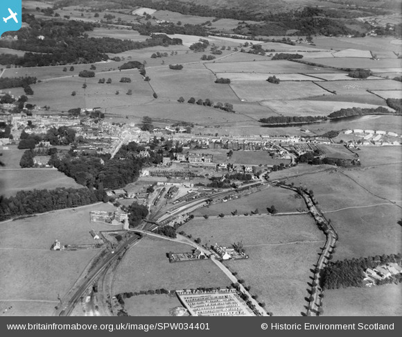
SPW034401 SCOTLAND (1930). Newton Stewart, general view, showing Corvisel Road and Newton Stewart Station. An oblique aerial photograph taken facing east.
© Copyright OpenStreetMap contributors and licensed by the OpenStreetMap Foundation. 2024. Cartography is licensed as CC BY-SA.
Details
| Title | [SPW034401] Newton Stewart, general view, showing Corvisel Road and Newton Stewart Station. An oblique aerial photograph taken facing east. |
| Reference | SPW034401 |
| Date | 1930 |
| Link | Canmore Collection item 1257132 |
| Place name | |
| Parish | PENNINGHAME |
| District | WIGTOWN |
| Country | SCOTLAND |
| Easting / Northing | 240877, 565060 |
| Longitude / Latitude | -4.4852248633137, 54.954671123871 |
| National Grid Reference | NX409651 |
Pins
 GarryDIrvine |
Saturday 24th of October 2020 02:56:37 PM | |
MB |
Thursday 18th of October 2012 07:16:49 PM | |
MB |
Thursday 18th of October 2012 07:15:03 PM | |
MB |
Thursday 18th of October 2012 07:13:12 PM | |
MB |
Thursday 18th of October 2012 07:12:21 PM | |
MB |
Thursday 18th of October 2012 07:10:06 PM | |
MB |
Thursday 18th of October 2012 07:07:15 PM | |
MB |
Thursday 18th of October 2012 07:06:30 PM | |
MB |
Thursday 18th of October 2012 07:05:29 PM | |
MB |
Thursday 18th of October 2012 07:04:38 PM | |
MB |
Thursday 18th of October 2012 07:02:58 PM | |
MB |
Thursday 18th of October 2012 07:02:25 PM | |
MB |
Thursday 18th of October 2012 07:01:27 PM | |
MB |
Thursday 18th of October 2012 07:00:51 PM | |
MB |
Thursday 18th of October 2012 06:59:54 PM | |
MB |
Thursday 18th of October 2012 06:58:22 PM | |
MB |
Thursday 18th of October 2012 06:57:48 PM | |
MB |
Thursday 18th of October 2012 06:57:03 PM |