
WPW048859 WALES (1935) [Unlocated]
© Copyright OpenStreetMap contributors and licensed by the OpenStreetMap Foundation. 2024. Cartography is licensed as CC BY-SA.
Nearby Images (48)
EPW000143

EPW000667

EPW005260

EPW006389
, 1921")
EPW007181

EPW015853

EPW015854

EPW015855

EPW016012

EPW016510

EPW016641

EPW017028

EPW017029

EPW017136

SAW003585

SAW003586

SAW009337

SAW009800

SAW009801

SAW009802

SAW010734

SAW014737

SAW017926

SAW017927

SAW032504

SPW020275

SPW020280

SPW020281

SPW020284

SPW020632

SPW020633

SPW027083

SPW049776

SPW049777

SPW049779

SPW049783

SPW049791

SPW049798

SPW049801

SPW049827

SPW049828

SPW049831

SPW049832

SPW049834

SPW049948

SPW049949

SPW051009

SPW062638

Details
| Title | WPW048859 |
| Reference | WPW048859 |
| Date | August-1935 |
| Link | |
| Place name | |
| Parish | |
| District | |
| Country | WALES |
| Easting / Northing | 0, 0 |
| Longitude / Latitude | -7.556448482059, 49.766185796754 |
| National Grid Reference | SV000000 |
Pins
 Class31 |
Sunday 19th of May 2013 06:31:13 AM | |
Class31 |
Saturday 18th of May 2013 12:08:10 PM | |
Class31 |
Saturday 18th of May 2013 11:56:14 AM | |
Class31 |
Saturday 18th of May 2013 11:52:31 AM | |
Class31 |
Saturday 18th of May 2013 11:03:42 AM | |
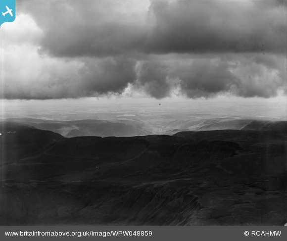
This is the Wyndham Colliery waste tip and is shown on the 1962 and 1965 OS maps of Nanymoel and Ogmore Vale. It was the placing of a colliery waste tip on a sloping mountainside which led to a slip after heavy rain and the terrible tragedy at Aberfan in 1966 when Pantglas School was engulfed. |
Class31 |
Saturday 18th of May 2013 12:05:40 PM |
User Comment Contributions
The incorrectly-numbered duplicate of this image has now been deleted. The contributions associated with it will also have been deleted. Please feel free to add your comments, pins and tags to this correct image. Yours, Jemima Britain from Above Web Admin Team |
Britain from Above |
Thursday 25th of September 2014 12:41:32 PM |
Eureka View looking south over Bwlchyclawdd towards Ogmore Vale in South Wales. Another photo which will have to be reclassified as Wales. The colliery waste tip was the clincher. I then noticed the road in the deep shadows in the foreground. There are few mountain roads in South Wales, most roads follow the valley floor. |
Class31 |
Tuesday 2nd of July 2013 03:15:42 PM |
Thank you for confirming the location! It will take a little longer to make the necessary changes, starting with the negative on the shelf and working all the way through to the catalogue and online record. Yours, Katy Britain from Above Cataloguing Team Leader |
Katy Whitaker |
Tuesday 2nd of July 2013 03:15:42 PM |