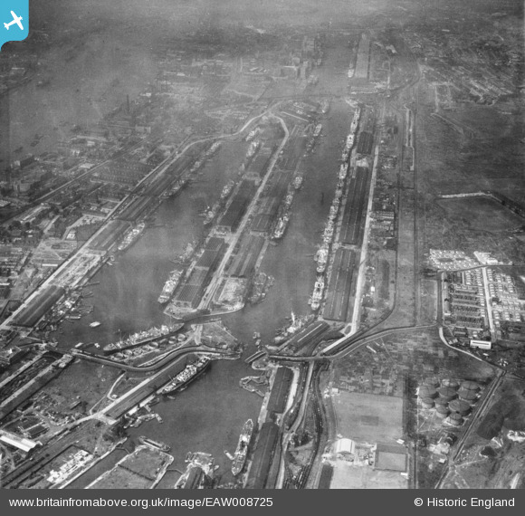
EAW008725 ENGLAND (1947). The Royal Albert Dock and the King George V Dock, North Woolwich, 1947
© Hawlfraint cyfranwyr OpenStreetMap a thrwyddedwyd gan yr OpenStreetMap Foundation. 2024. Trwyddedir y gartograffeg fel CC BY-SA.
Delweddau cyfagos (22)
Manylion
| Pennawd | [EAW008725] The Royal Albert Dock and the King George V Dock, North Woolwich, 1947 |
| Cyfeirnod | EAW008725 |
| Dyddiad | 8-August-1947 |
| Dolen | |
| Enw lle | NORTH WOOLWICH |
| Plwyf | |
| Ardal | |
| Gwlad | ENGLAND |
| Dwyreiniad / Gogleddiad | 543222, 180522 |
| Hydred / Lledred | 0.063861682865568, 51.504974752058 |
| Cyfeirnod Grid Cenedlaethol | TQ432805 |
Pinnau
 redmist |
Tuesday 30th of June 2020 07:37:48 PM | |
 redmist |
Monday 29th of June 2020 08:12:23 PM | |
 redmist |
Monday 29th of June 2020 08:10:55 PM | |
 redmist |
Monday 29th of June 2020 08:10:28 PM |


![[EAW008725] The Royal Albert Dock and the King George V Dock, North Woolwich, 1947](http://britainfromabove.org.uk/sites/all/libraries/aerofilms-images/public/100x100/EAW/008/EAW008725.jpg)
![[EPW010727] Ships moored in the Royal Albert Dock and the King George V Dock, North Woolwich, 1924. This image has been produced from a copy-negative.](http://britainfromabove.org.uk/sites/all/libraries/aerofilms-images/public/100x100/EPW/010/EPW010727.jpg)
![[EPW032937] The Royal Albert Dock and King George V Dock, North Woolwich, 1930](http://britainfromabove.org.uk/sites/all/libraries/aerofilms-images/public/100x100/EPW/032/EPW032937.jpg)
![[EAW021703] The Royal Albert Dock and the King George V Dock, North Woolwich, 1949. This image has been produced from a print.](http://britainfromabove.org.uk/sites/all/libraries/aerofilms-images/public/100x100/EAW/021/EAW021703.jpg)
![[EPW032936] The Royal Albert Dock and King George V Dock, North Woolwich, 1930](http://britainfromabove.org.uk/sites/all/libraries/aerofilms-images/public/100x100/EPW/032/EPW032936.jpg)
![[EAW008727] The Royal Albert Dock and the King George V Dock, North Woolwich, 1947](http://britainfromabove.org.uk/sites/all/libraries/aerofilms-images/public/100x100/EAW/008/EAW008727.jpg)
![[EAW022357] The Royal Albert and King George V Docks, North Woolwich, 1949](http://britainfromabove.org.uk/sites/all/libraries/aerofilms-images/public/100x100/EAW/022/EAW022357.jpg)
![[EAW008726] The Royal Albert Dock and the King George V Dock, North Woolwich, 1947](http://britainfromabove.org.uk/sites/all/libraries/aerofilms-images/public/100x100/EAW/008/EAW008726.jpg)
![[EAW000057] The Royal Victoria Dock, the Royal Albert Dock and the King George V Dock, North Woolwich, 1946. This image was produced from a print.](http://britainfromabove.org.uk/sites/all/libraries/aerofilms-images/public/100x100/EAW/000/EAW000057.jpg)
![[EAW005289] The Royal Albert Dock, King George V Dock and environs, North Woolwich, from the south-east, 1947](http://britainfromabove.org.uk/sites/all/libraries/aerofilms-images/public/100x100/EAW/005/EAW005289.jpg)
![[EAW000058] The King George V Dock and the Royal Albert Dock, Beckton, 1946. This image has been produced from a damaged negative.](http://britainfromabove.org.uk/sites/all/libraries/aerofilms-images/public/100x100/EAW/000/EAW000058.jpg)
![[EAW000054] The King George V Dock and the Royal Albert Dock, Beckton, 1946](http://britainfromabove.org.uk/sites/all/libraries/aerofilms-images/public/100x100/EAW/000/EAW000054.jpg)
![[EAW021713] The Royal Albert Dock and the King George V Dock, North Woolwich, 1949. This image has been produced from a print.](http://britainfromabove.org.uk/sites/all/libraries/aerofilms-images/public/100x100/EAW/021/EAW021713.jpg)
![[EAW016657] The Royal Albert Dock, King George V Dock, River Thames and environs, North Woolwich, from the north-west, 1948](http://britainfromabove.org.uk/sites/all/libraries/aerofilms-images/public/100x100/EAW/016/EAW016657.jpg)
![[EPW032935] The Royal Albert Dock and King George V Dock, North Woolwich, 1930](http://britainfromabove.org.uk/sites/all/libraries/aerofilms-images/public/100x100/EPW/032/EPW032935.jpg)
![[EAW049351] The Royal Group of Docks, North Woolwich, 1953](http://britainfromabove.org.uk/sites/all/libraries/aerofilms-images/public/100x100/EAW/049/EAW049351.jpg)
![[EPW021370] The Royal Albert and King George V Docks, North Woolwich, 1928](http://britainfromabove.org.uk/sites/all/libraries/aerofilms-images/public/100x100/EPW/021/EPW021370.jpg)
![[EAW000051] The King George V Dock and the Royal Albert Dock, Beckton, 1946](http://britainfromabove.org.uk/sites/all/libraries/aerofilms-images/public/100x100/EAW/000/EAW000051.jpg)
![[EPW008887] King George V Dock and the Royal Albert Dock, North Woolwich, 1923. This image has been produced from a print.](http://britainfromabove.org.uk/sites/all/libraries/aerofilms-images/public/100x100/EPW/008/EPW008887.jpg)
![[EAW000037] The King George V Dock and the Royal Albert Dock, Beckton, 1946. This image has been produced from a damaged negative.](http://britainfromabove.org.uk/sites/all/libraries/aerofilms-images/public/100x100/EAW/000/EAW000037.jpg)
![[EAW021704] The Royal Albert Dock and the King George V Dock, North Woolwich, 1949. This image has been produced from a print.](http://britainfromabove.org.uk/sites/all/libraries/aerofilms-images/public/100x100/EAW/021/EAW021704.jpg)
![[EPW010729] Ships moored in the Royal Albert Dock and the King George V Dock, North Woolwich, 1924. This image has been produced from a print.](http://britainfromabove.org.uk/sites/all/libraries/aerofilms-images/public/100x100/EPW/010/EPW010729.jpg)