
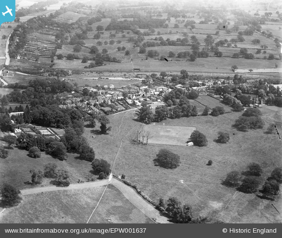
EPW001637 ENGLAND (1920). Merstham village, Merstham, 1920
© Hawlfraint cyfranwyr OpenStreetMap a thrwyddedwyd gan yr OpenStreetMap Foundation. 2025. Trwyddedir y gartograffeg fel CC BY-SA.
Manylion
| Pennawd | [EPW001637] Merstham village, Merstham, 1920 |
| Cyfeirnod | EPW001637 |
| Dyddiad | June-1920 |
| Dolen | |
| Enw lle | MERSTHAM |
| Plwyf | |
| Ardal | |
| Gwlad | ENGLAND |
| Dwyreiniad / Gogleddiad | 528870, 153355 |
| Hydred / Lledred | -0.15269159900703, 51.264254082662 |
| Cyfeirnod Grid Cenedlaethol | TQ289534 |
Pinnau
 christhewino |
Tuesday 28th of November 2023 06:49:13 PM | |
christhewino |
Tuesday 28th of November 2023 06:48:11 PM | |
toby starr |
Friday 19th of March 2021 11:13:52 AM | |
Southerbrooke |
Wednesday 25th of January 2017 07:19:33 PM | |
 Class31 |
Sunday 21st of October 2012 07:54:46 PM | |
Class31 |
Sunday 21st of October 2012 07:52:57 PM | |
Class31 |
Sunday 21st of October 2012 07:52:12 PM | |
Class31 |
Sunday 21st of October 2012 07:50:21 PM |
Cyfraniadau Grŵp
The cricket pitch in the centre here is still in active use. Sadly this photo just misses Mertham House (Lord Hylton's seat but rented out to the Walker family at this time - it was pulled down in the 1950s) and the parish church to the left. The M25 now runs diagonally across the top left, below the gardens of the houses on Rockshaw Road. A golf course now takes up the foreground of this picture. |
Venator |
Sunday 1st of July 2012 12:01:12 PM |