
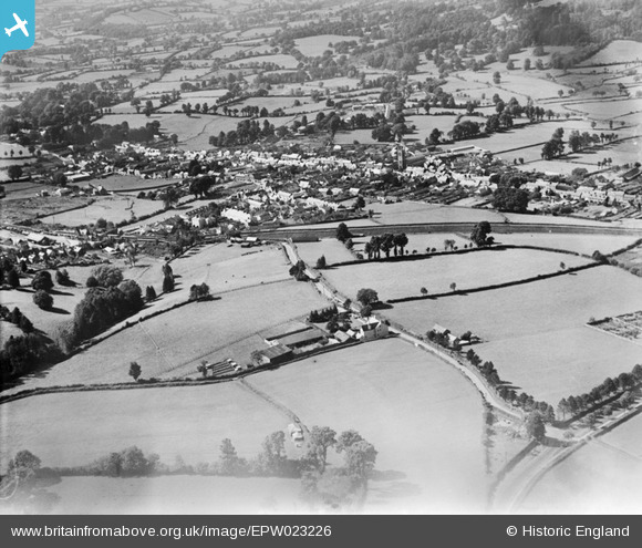
EPW023226 ENGLAND (1928). Honiton and environs, Honiton, from the south-east, 1928
© Hawlfraint cyfranwyr OpenStreetMap a thrwyddedwyd gan yr OpenStreetMap Foundation. 2025. Trwyddedir y gartograffeg fel CC BY-SA.
Manylion
| Pennawd | [EPW023226] Honiton and environs, Honiton, from the south-east, 1928 |
| Cyfeirnod | EPW023226 |
| Dyddiad | September-1928 |
| Dolen | |
| Enw lle | HONITON |
| Plwyf | HONITON |
| Ardal | |
| Gwlad | ENGLAND |
| Dwyreiniad / Gogleddiad | 316944, 100405 |
| Hydred / Lledred | -3.1786330710449, 50.79668481996 |
| Cyfeirnod Grid Cenedlaethol | ST169004 |
Pinnau
Allen T |
Wednesday 10th of October 2012 12:10:28 AM | |
Allen T |
Monday 8th of October 2012 12:38:54 AM | |
Allen T |
Sunday 7th of October 2012 06:46:54 PM | |
Allen T |
Sunday 7th of October 2012 06:25:12 PM |
Cyfraniadau Grŵp
The straight High Street crosses the top third of the photo and the railway line curves across the centre. Pine Park Road comes from centre of photo to bottom right, passing Pine Park House (centre of photo, alongside Parsonage Lane) joining Axminster Road (the A35) which cuts diagonally across the bottom right |
 Withdrawn |
Tuesday 26th of June 2012 12:46:37 PM |