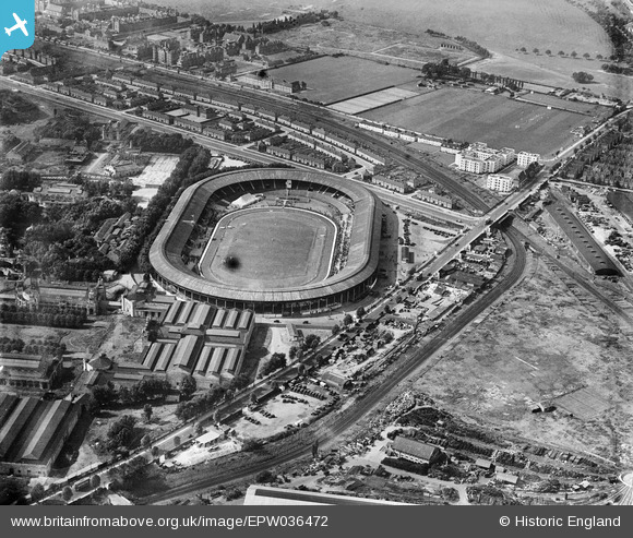
EPW036472 ENGLAND (1931). Shepherd's Bush, a greyhound race meeting in progress at the White City Stadium and environs, 1931
© Hawlfraint cyfranwyr OpenStreetMap a thrwyddedwyd gan yr OpenStreetMap Foundation. 2025. Trwyddedir y gartograffeg fel CC BY-SA.
Delweddau cyfagos (48)
Manylion
| Pennawd | [EPW036472] Shepherd's Bush, a greyhound race meeting in progress at the White City Stadium and environs, 1931 |
| Cyfeirnod | EPW036472 |
| Dyddiad | August-1931 |
| Dolen | |
| Enw lle | SHEPHERD'S BUSH |
| Plwyf | |
| Ardal | |
| Gwlad | ENGLAND |
| Dwyreiniad / Gogleddiad | 523132, 180911 |
| Hydred / Lledred | -0.22534238117966, 51.513206637529 |
| Cyfeirnod Grid Cenedlaethol | TQ231809 |
Pinnau
Byddwch y cyntaf i ychwanegu sylw at y ddelwedd hon!


![[EPW036469] Shepherd's Bush, a greyhound race meeting in progress at the White City Stadium, 1931](http://britainfromabove.org.uk/sites/all/libraries/aerofilms-images/public/100x100/EPW/036/EPW036469.jpg)
![[EPW054551] Shepherd's Bush, the International Athletics Meeting at the White City Stadium, 1937](http://britainfromabove.org.uk/sites/all/libraries/aerofilms-images/public/100x100/EPW/054/EPW054551.jpg)
![[EPW036468] Shepherd's Bush, a greyhound race meeting in progress at the White City Stadium and environs, 1931](http://britainfromabove.org.uk/sites/all/libraries/aerofilms-images/public/100x100/EPW/036/EPW036468.jpg)
![[EPW036470] Shepherd's Bush, a greyhound race meeting in progress at the White City Stadium, 1931](http://britainfromabove.org.uk/sites/all/libraries/aerofilms-images/public/100x100/EPW/036/EPW036470.jpg)
![[EPW053787] Shepherd's Bush, crowds gathering within the White City Stadium for a Greyhound Race Meeting, 1937](http://britainfromabove.org.uk/sites/all/libraries/aerofilms-images/public/100x100/EPW/053/EPW053787.jpg)
![[EPW036473] Shepherd's Bush, a greyhound race meeting in progress at the White City Stadium, 1931](http://britainfromabove.org.uk/sites/all/libraries/aerofilms-images/public/100x100/EPW/036/EPW036473.jpg)
![[EPW054547] Shepherd's Bush, the International Athletics Meeting at the White City Stadium, 1937](http://britainfromabove.org.uk/sites/all/libraries/aerofilms-images/public/100x100/EPW/054/EPW054547.jpg)
![[EPW036465] Shepherd's Bush, a greyhound race meeting in progress at the White City Stadium, 1931](http://britainfromabove.org.uk/sites/all/libraries/aerofilms-images/public/100x100/EPW/036/EPW036465.jpg)
![[EPW031086] Shepherd's Bush, a greyhound meeting in progress at the White City Stadium, 1929](http://britainfromabove.org.uk/sites/all/libraries/aerofilms-images/public/100x100/EPW/031/EPW031086.jpg)
![[EPW046819] The White City Stadium, Shepherd's Bush, 1935](http://britainfromabove.org.uk/sites/all/libraries/aerofilms-images/public/100x100/EPW/046/EPW046819.jpg)
![[EPW054545] Shepherd's Bush, the International Athletics Meeting at the White City Stadium, 1937](http://britainfromabove.org.uk/sites/all/libraries/aerofilms-images/public/100x100/EPW/054/EPW054545.jpg)
![[EPW031082] Shepherd's Bush, a greyhound meeting in progress at the White City Stadium, 1929. This image has been produced from a damaged negative.](http://britainfromabove.org.uk/sites/all/libraries/aerofilms-images/public/100x100/EPW/031/EPW031082.jpg)
![[EPW031078] The White City Stadium and Exhibition Centre, Shepherd's Bush, 1929](http://britainfromabove.org.uk/sites/all/libraries/aerofilms-images/public/100x100/EPW/031/EPW031078.jpg)
![[EPW031077] Shepherd's Bush, a greyhound meeting in progress at the White City Stadium, 1929](http://britainfromabove.org.uk/sites/all/libraries/aerofilms-images/public/100x100/EPW/031/EPW031077.jpg)
![[EPW031079] Shepherd's Bush, a greyhound meeting in progress at the White City Stadium, 1929](http://britainfromabove.org.uk/sites/all/libraries/aerofilms-images/public/100x100/EPW/031/EPW031079.jpg)
![[EPW042217] Shepherd's Bush, crowds gathering for a boxing match at White City Stadium (possibly Jack Petersen/Jack Doyle fight), 1933](http://britainfromabove.org.uk/sites/all/libraries/aerofilms-images/public/100x100/EPW/042/EPW042217.jpg)
![[EPW054550] Shepherd's Bush, the International Athletics Meeting at the White City Stadium, 1937](http://britainfromabove.org.uk/sites/all/libraries/aerofilms-images/public/100x100/EPW/054/EPW054550.jpg)
![[EPW053782] Shepherd's Bush, crowds gathering within the White City Stadium for a Greyhound Race Meeting, 1937](http://britainfromabove.org.uk/sites/all/libraries/aerofilms-images/public/100x100/EPW/053/EPW053782.jpg)
![[EPW031087] Shepherd's Bush, a greyhound meeting in progress at the White City Stadium, 1929](http://britainfromabove.org.uk/sites/all/libraries/aerofilms-images/public/100x100/EPW/031/EPW031087.jpg)
![[EPW036464] Shepherd's Bush, a greyhound race meeting in progress at the White City Stadium, 1931](http://britainfromabove.org.uk/sites/all/libraries/aerofilms-images/public/100x100/EPW/036/EPW036464.jpg)
![[EPW054548] Shepherd's Bush, the International Athletics Meeting at the White City Stadium, 1937](http://britainfromabove.org.uk/sites/all/libraries/aerofilms-images/public/100x100/EPW/054/EPW054548.jpg)
![[EPW031083] Shepherd's Bush, a greyhound meeting in progress at the White City Stadium, 1929. This image has been produced from a damaged negative.](http://britainfromabove.org.uk/sites/all/libraries/aerofilms-images/public/100x100/EPW/031/EPW031083.jpg)
![[EPW022638] The White City Olympic Stadium and The Great White City, Shepherd's Bush, 1928](http://britainfromabove.org.uk/sites/all/libraries/aerofilms-images/public/100x100/EPW/022/EPW022638.jpg)
![[EPW054546] Shepherd's Bush, the International Athletics Meeting at the White City Stadium, 1937](http://britainfromabove.org.uk/sites/all/libraries/aerofilms-images/public/100x100/EPW/054/EPW054546.jpg)
![[EPW022643] The White City Olympic Stadium, Shepherd's Bush, 1928](http://britainfromabove.org.uk/sites/all/libraries/aerofilms-images/public/100x100/EPW/022/EPW022643.jpg)
![[EPW022644] The White City Olympic Stadium and The Great White City, Shepherd's Bush, 1928](http://britainfromabove.org.uk/sites/all/libraries/aerofilms-images/public/100x100/EPW/022/EPW022644.jpg)
![[EPW022641] The White City Olympic Stadium, Shepherd's Bush, 1928](http://britainfromabove.org.uk/sites/all/libraries/aerofilms-images/public/100x100/EPW/022/EPW022641.jpg)
![[EPW042221] Shepherd's Bush, crowds gathering for a boxing match at White City Stadium (possibly Jack Petersen/Jack Doyle fight), 1933](http://britainfromabove.org.uk/sites/all/libraries/aerofilms-images/public/100x100/EPW/042/EPW042221.jpg)
![[EPW053795] Shepherd's Bush, a Greyhound Race Meeting at the White City Stadium, 1937](http://britainfromabove.org.uk/sites/all/libraries/aerofilms-images/public/100x100/EPW/053/EPW053795.jpg)
![[EPW056836] The White City Stadium, Shepherd's Bush, 1938](http://britainfromabove.org.uk/sites/all/libraries/aerofilms-images/public/100x100/EPW/056/EPW056836.jpg)
![[EPW022642] The White City Olympic Stadium and The Great White City, Shepherd's Bush, 1928](http://britainfromabove.org.uk/sites/all/libraries/aerofilms-images/public/100x100/EPW/022/EPW022642.jpg)
![[EPW054549] Shepherd's Bush, the International Athletics Meeting at the White City Stadium, 1937](http://britainfromabove.org.uk/sites/all/libraries/aerofilms-images/public/100x100/EPW/054/EPW054549.jpg)
![[EPW031084] Shepherd's Bush, a greyhound meeting in progress at the White City Stadium, 1929. This image has been produced from a damaged negative.](http://britainfromabove.org.uk/sites/all/libraries/aerofilms-images/public/100x100/EPW/031/EPW031084.jpg)
![[EPW031085] Shepherd's Bush, a greyhound meeting in progress at the White City Stadium, 1929. This image has been produced from a damaged negative.](http://britainfromabove.org.uk/sites/all/libraries/aerofilms-images/public/100x100/EPW/031/EPW031085.jpg)
![[EPW036466] Shepherd's Bush, a greyhound race meeting in progress at the White City Stadium, 1931](http://britainfromabove.org.uk/sites/all/libraries/aerofilms-images/public/100x100/EPW/036/EPW036466.jpg)
![[EPW022639] The White City Olympic Stadium, Shepherd's Bush, 1928](http://britainfromabove.org.uk/sites/all/libraries/aerofilms-images/public/100x100/EPW/022/EPW022639.jpg)
![[EPW053792] Shepherd's Bush, a Greyhound Race Meeting at the White City Stadium, 1937](http://britainfromabove.org.uk/sites/all/libraries/aerofilms-images/public/100x100/EPW/053/EPW053792.jpg)
![[EPW042220] Shepherd's Bush, crowds gathering for a boxing match at White City Stadium (possibly Jack Petersen/Jack Doyle fight), 1933](http://britainfromabove.org.uk/sites/all/libraries/aerofilms-images/public/100x100/EPW/042/EPW042220.jpg)
![[EPW031081] Shepherd's Bush, a greyhound meeting in progress at the White City Stadium, 1929. This image has been produced from a damaged negative.](http://britainfromabove.org.uk/sites/all/libraries/aerofilms-images/public/100x100/EPW/031/EPW031081.jpg)
![[EPW042222] Shepherd's Bush, crowds gathering for a boxing match at White City Stadium (possibly Jack Petersen/Jack Doyle fight), 1933](http://britainfromabove.org.uk/sites/all/libraries/aerofilms-images/public/100x100/EPW/042/EPW042222.jpg)
![[EPW042223] Shepherd's Bush, crowds gathering for a boxing match at White City Stadium (possibly Jack Petersen/Jack Doyle fight), 1933](http://britainfromabove.org.uk/sites/all/libraries/aerofilms-images/public/100x100/EPW/042/EPW042223.jpg)
![[EPW021262] The White City Stadium and environs, Shepherd's Bush, 1928](http://britainfromabove.org.uk/sites/all/libraries/aerofilms-images/public/100x100/EPW/021/EPW021262.jpg)
![[EPW021263] The White City Stadium and environs, Shepherd's Bush, 1928](http://britainfromabove.org.uk/sites/all/libraries/aerofilms-images/public/100x100/EPW/021/EPW021263.jpg)
![[EPW019018] White City, Shepherd's Bush, 1927. This image has been produced from a damaged print.](http://britainfromabove.org.uk/sites/all/libraries/aerofilms-images/public/100x100/EPW/019/EPW019018.jpg)
![[EPW062153] White City and the Olympic Stadium, Shepherd's Bush, 1939](http://britainfromabove.org.uk/sites/all/libraries/aerofilms-images/public/100x100/EPW/062/EPW062153.jpg)
![[EPW042219] Shepherd's Bush, crowds gathering for a boxing match at White City Stadium (possibly Jack Petersen/Jack Doyle fight), 1933](http://britainfromabove.org.uk/sites/all/libraries/aerofilms-images/public/100x100/EPW/042/EPW042219.jpg)
![[EAW005414] The White City Estate, White City Stadium and environs, Shepherd's Bush, 1947](http://britainfromabove.org.uk/sites/all/libraries/aerofilms-images/public/100x100/EAW/005/EAW005414.jpg)
![[EAW005407] The White City Estate and White City Stadium, Shepherd's Bush, from the north-east, 1947. This image was marked by Aerofilms Ltd for photo editing.](http://britainfromabove.org.uk/sites/all/libraries/aerofilms-images/public/100x100/EAW/005/EAW005407.jpg)