 Wrinkleberry (place name) |

totoro |
Tuesday 21st of October 2014 08:34:53 PM |
 Burscott (place name) |

totoro |
Tuesday 21st of October 2014 08:34:36 PM |
 141, Clovelly, EX39 5RW
Grade 2 listed building - English Heritage Building ID: 91180
Cottage. Probably early C17, Part rebuilt in the C18, including reroofing, some C19 refenestration. Rubble, part rendered, whitewashed, straw-thatched roof to half-hipped ends; tall rendered front lateral stack rising from the eaves. |

totoro |
Tuesday 21st of October 2014 08:23:52 PM |
Shown on current OS as Winsworthy Cottage |

totoro |
Tuesday 21st of October 2014 08:24:50 PM |
 West Dyke Farm |

totoro |
Tuesday 21st of October 2014 08:22:02 PM |
 Not something you see often on a listed monument - a goal post. No longer there. |

totoro |
Tuesday 21st of October 2014 08:13:07 PM |
 Dyke Green Farm |

totoro |
Tuesday 21st of October 2014 08:12:31 PM |
 East Dyke Farm |

totoro |
Tuesday 21st of October 2014 08:12:06 PM |
 This area has since been cleared. |

totoro |
Tuesday 21st of October 2014 07:38:56 PM |
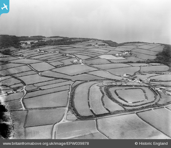
 Clovelly Dykes
Private Property. Part of East Dyke Farm. Scheduled Ancient Monument. MONUMENT NUMBER: 32663 Consent required for any works to the site. The location is a junction of three ridgeways.
Iron age "hill fort" on a flat site, a series of earthworks (five concentric enclosures) covering more than 20 acres. Concentric ring ditches and enclosure. The road to Clovelly village cuts through the outer area of the site. The ground underneath the modern intrusive structures remains listed.
No excavation appears to have been made of the site.
Due to indicators including the positioning, scale and entrance features, it is believed that the hillfort did not serve a particularly defensive function. Instead it possibly played a key role in the seasonal gathering of livestock. High status items such as a blue glass bead and a high quality axe have been found here.
The inner two areas form the first phase possibly 1st C BC.
The monument survives as a series of enclosures, demarcated by rampart banks and ditches. The innermost enclosure is sub rectangular in shape with an entrance to the east; the rampart measures up to 2.1m high, and the ditch survives as a buried feature. The second enclosure is concentric to the first with entrances to the east and south east. The rampart to this stands up to 3m high, the outer ditch is up to 3.5m deep. The outermost enclosure is roughly triangular in plan and has a steep rampart up to 3m high. The outer ditch survives as a buried feature to the east, and south, but is up to 3m deep on the western and northern sides. There is a curving overlapped entrance to the north. Within the outer enclosure the hillfort seems to have been subdivided by two smaller ramparts which run approximately north to south on the western side, the banks attain a height of up to 2.5m and the accompanying ditches are both preserved as buried features. To the north west a large farm with its associated buildings has cut into the outer rampart and ditch.
See also- Report by G E L Carter in Devonian Year Book, 1927. |

totoro |
Tuesday 21st of October 2014 07:37:49 PM |


![[EPW039878] Clovelly Dykes Hillfort and surrounding countryside, Higher Clovelly, from the south-west, 1932](http://britainfromabove.org.uk/sites/all/libraries/aerofilms-images/public/100x100/EPW/039/EPW039878.jpg)
![[EPW039881] Clovelly Dykes Hillfort and surrounding countryside, Higher Clovelly, 1932](http://britainfromabove.org.uk/sites/all/libraries/aerofilms-images/public/100x100/EPW/039/EPW039881.jpg)
![[EPW039877] Clovelly Dykes Hillfort and surrounding countryside, Higher Clovelly, from the south, 1932](http://britainfromabove.org.uk/sites/all/libraries/aerofilms-images/public/100x100/EPW/039/EPW039877.jpg)
![[EPW039880] Clovelly Dykes Hillfort and surrounding countryside, Higher Clovelly, 1932](http://britainfromabove.org.uk/sites/all/libraries/aerofilms-images/public/100x100/EPW/039/EPW039880.jpg)
![[EPW039879] Clovelly Dykes Hillfort and surrounding countryside, Higher Clovelly, from the south-west, 1932. This image has been produced from a damaged negative.](http://britainfromabove.org.uk/sites/all/libraries/aerofilms-images/public/100x100/EPW/039/EPW039879.jpg)