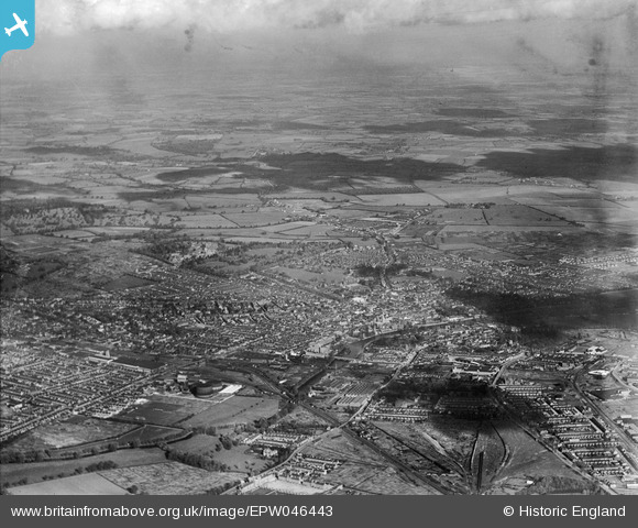
EPW046443 ENGLAND (1934). The town, Bedford, from the south-west, 1934
© Hawlfraint cyfranwyr OpenStreetMap a thrwyddedwyd gan yr OpenStreetMap Foundation. 2024. Trwyddedir y gartograffeg fel CC BY-SA.
Delweddau cyfagos (12)
Manylion
| Pennawd | [EPW046443] The town, Bedford, from the south-west, 1934 |
| Cyfeirnod | EPW046443 |
| Dyddiad | October-1934 |
| Dolen | |
| Enw lle | BEDFORD |
| Plwyf | |
| Ardal | |
| Gwlad | ENGLAND |
| Dwyreiniad / Gogleddiad | 504651, 249283 |
| Hydred / Lledred | -0.47092235054183, 52.131518722356 |
| Cyfeirnod Grid Cenedlaethol | TL047493 |
Pinnau
 melgibbs |
Sunday 24th of November 2013 10:49:35 AM | |
 melgibbs |
Monday 10th of June 2013 08:18:03 PM | |
 melgibbs |
Monday 10th of June 2013 08:16:39 PM | |
 melgibbs |
Monday 10th of June 2013 08:16:10 PM | |
 melgibbs |
Monday 10th of June 2013 08:15:03 PM | |
 melgibbs |
Monday 10th of June 2013 08:12:14 PM | |
 melgibbs |
Monday 10th of June 2013 08:10:30 PM | |
 melgibbs |
Monday 10th of June 2013 08:08:34 PM | |
 melgibbs |
Monday 10th of June 2013 08:07:46 PM | |
 melgibbs |
Monday 10th of June 2013 08:07:08 PM | |
 melgibbs |
Monday 10th of June 2013 08:05:30 PM | |
 melgibbs |
Monday 10th of June 2013 08:04:52 PM | |
 melgibbs |
Monday 10th of June 2013 08:03:31 PM | |
 melgibbs |
Monday 10th of June 2013 08:02:38 PM | |
 melgibbs |
Monday 10th of June 2013 08:01:50 PM | |
 melgibbs |
Monday 10th of June 2013 07:59:49 PM | |
 melgibbs |
Monday 10th of June 2013 07:52:21 PM | |
 melgibbs |
Monday 10th of June 2013 07:46:04 PM | |
 melgibbs |
Monday 10th of June 2013 07:45:34 PM | |
 melgibbs |
Monday 10th of June 2013 07:45:02 PM | |
 melgibbs |
Monday 10th of June 2013 07:43:47 PM | |
 melgibbs |
Monday 10th of June 2013 07:42:37 PM | |
 melgibbs |
Monday 10th of June 2013 07:42:01 PM | |
 melgibbs |
Monday 10th of June 2013 07:41:31 PM | |
 melgibbs |
Monday 10th of June 2013 07:40:23 PM | |
 melgibbs |
Monday 10th of June 2013 07:39:39 PM | |
 melgibbs |
Monday 10th of June 2013 07:38:38 PM | |
 melgibbs |
Monday 10th of June 2013 07:38:11 PM | |
 melgibbs |
Monday 10th of June 2013 07:37:41 PM | |
 melgibbs |
Monday 10th of June 2013 07:37:10 PM | |
 melgibbs |
Monday 10th of June 2013 07:36:45 PM | |
 melgibbs |
Monday 10th of June 2013 07:35:49 PM | |
 melgibbs |
Monday 10th of June 2013 07:35:20 PM | |
 melgibbs |
Monday 10th of June 2013 07:34:10 PM | |
 melgibbs |
Monday 10th of June 2013 07:31:47 PM | |
 melgibbs |
Monday 10th of June 2013 07:30:25 PM | |
 melgibbs |
Monday 10th of June 2013 07:29:47 PM | |
 melgibbs |
Monday 10th of June 2013 07:28:27 PM | |
 melgibbs |
Monday 10th of June 2013 07:27:59 PM | |
 melgibbs |
Monday 10th of June 2013 07:27:03 PM | |
 melgibbs |
Monday 10th of June 2013 07:26:38 PM | |
 melgibbs |
Monday 10th of June 2013 07:25:59 PM | |
The 1924 map of Bedford has this stretch of road named as Cauldwell Road and becomes Prebend Street after the Commercial Road junction, but the whole length of road between Cauldwell Street corner and Midland Road is now called Prebend Street. |
 melgibbs |
Saturday 22nd of June 2013 08:13:21 PM |
 melgibbs |
Monday 10th of June 2013 07:25:23 PM | |
 melgibbs |
Monday 10th of June 2013 07:24:47 PM | |
 melgibbs |
Monday 10th of June 2013 07:24:16 PM | |
 melgibbs |
Monday 10th of June 2013 07:21:28 PM | |
 melgibbs |
Monday 10th of June 2013 07:19:52 PM | |
 melgibbs |
Monday 10th of June 2013 07:19:20 PM | |
 melgibbs |
Monday 10th of June 2013 07:16:50 PM | |
 melgibbs |
Monday 10th of June 2013 07:13:48 PM | |
 melgibbs |
Monday 10th of June 2013 07:06:41 PM | |
 melgibbs |
Monday 10th of June 2013 07:06:08 PM | |
 melgibbs |
Monday 10th of June 2013 07:05:36 PM |
Cyfraniadau Grŵp
Granville Street taken on 30th October 2009. |
 melgibbs |
Monday 10th of June 2013 07:18:34 PM |


![[EPW046443] The town, Bedford, from the south-west, 1934](http://britainfromabove.org.uk/sites/all/libraries/aerofilms-images/public/100x100/EPW/046/EPW046443.jpg)
![[EPW022392] The town, Bedford, from the west, 1928.](http://britainfromabove.org.uk/sites/all/libraries/aerofilms-images/public/100x100/EPW/022/EPW022392.jpg)
![[EAW032057] The Britannia Iron and Steel Works, Bedford, 1950. This image was marked by Aerofilms Ltd for photo editing.](http://britainfromabove.org.uk/sites/all/libraries/aerofilms-images/public/100x100/EAW/032/EAW032057.jpg)
![[EAW032056] The Britannia Iron and Steel Works, Bedford, 1950. This image was marked by Aerofilms Ltd for photo editing.](http://britainfromabove.org.uk/sites/all/libraries/aerofilms-images/public/100x100/EAW/032/EAW032056.jpg)
![[EAW032062] The Britannia Iron and Steel Works off Kempston Road, Bedford, 1950. This image was marked by Aerofilms Ltd for photo editing.](http://britainfromabove.org.uk/sites/all/libraries/aerofilms-images/public/100x100/EAW/032/EAW032062.jpg)
![[EPW022382] The town centre, Bedford, from the south-east, 1928.](http://britainfromabove.org.uk/sites/all/libraries/aerofilms-images/public/100x100/EPW/022/EPW022382.jpg)
![[EPW045605] The Britannia Iron Works and environs, Bedford, from the east, 1934. This image has been produced from a damaged negative.](http://britainfromabove.org.uk/sites/all/libraries/aerofilms-images/public/100x100/EPW/045/EPW045605.jpg)
![[EAW032053] The Britannia Iron and Steel Works, Bedford, 1950. This image was marked by Aerofilms Ltd for photo editing.](http://britainfromabove.org.uk/sites/all/libraries/aerofilms-images/public/100x100/EAW/032/EAW032053.jpg)
![[EAW032054] The Britannia Iron and Steel Works off Kempston Road and environs, Bedford, 1950](http://britainfromabove.org.uk/sites/all/libraries/aerofilms-images/public/100x100/EAW/032/EAW032054.jpg)
![[EPW045530] The Britannia Iron Works and the environs, Bedford, 1934](http://britainfromabove.org.uk/sites/all/libraries/aerofilms-images/public/100x100/EPW/045/EPW045530.jpg)
![[EPW045529] The Britannia Iron Works and the environs, Bedford, 1934. This image has been produced from a damaged negative.](http://britainfromabove.org.uk/sites/all/libraries/aerofilms-images/public/100x100/EPW/045/EPW045529.jpg)
![[EPW045525] The Britannia Iron Works, Bedford, 1934. This image has been produced from a damaged negative.](http://britainfromabove.org.uk/sites/all/libraries/aerofilms-images/public/100x100/EPW/045/EPW045525.jpg)

