
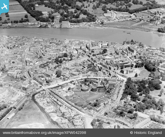
XPW042398 IRELAND (1933). General View, Waterford, Waterford, Ireland, 1933. Oblique aerial photograph taken facing North.
© Hawlfraint cyfranwyr OpenStreetMap a thrwyddedwyd gan yr OpenStreetMap Foundation. 2025. Trwyddedir y gartograffeg fel CC BY-SA.
Manylion
| Pennawd | [XPW042398] General View, Waterford, Waterford, Ireland, 1933. Oblique aerial photograph taken facing North. |
| Cyfeirnod | XPW042398 |
| Dyddiad | 1933 |
| Dolen | |
| Enw lle | WATERFORD |
| Plwyf | IRELAND |
| Ardal | |
| Gwlad | IRELAND |
| Dwyreiniad / Gogleddiad | 51474, 274169 |
| Hydred / Lledred | -7.108829, 52.254953 |
| Cyfeirnod Grid Cenedlaethol |
Pinnau
 ofarrl1960 |
Saturday 11th of November 2017 07:00:08 PM | |
ofarrl1960 |
Saturday 11th of November 2017 06:58:45 PM | |
ofarrl1960 |
Saturday 11th of November 2017 06:56:32 PM | |
ofarrl1960 |
Saturday 11th of November 2017 01:08:33 AM | |
ofarrl1960 |
Saturday 11th of November 2017 01:06:47 AM | |
 John Swain |
Thursday 9th of October 2014 10:28:17 AM | |
John Swain |
Thursday 9th of October 2014 10:05:48 AM | |
John Swain |
Thursday 9th of October 2014 09:58:40 AM | |
John Swain |
Thursday 9th of October 2014 09:56:51 AM | |
John Swain |
Thursday 9th of October 2014 09:53:58 AM | |
John Swain |
Thursday 9th of October 2014 09:53:03 AM | |
John Swain |
Thursday 9th of October 2014 09:50:42 AM | |
John Swain |
Thursday 9th of October 2014 09:49:52 AM | |
John Swain |
Thursday 9th of October 2014 09:48:08 AM | |
John Swain |
Thursday 9th of October 2014 09:47:33 AM | |
John Swain |
Thursday 9th of October 2014 09:46:40 AM | |
John Swain |
Thursday 9th of October 2014 09:44:28 AM | |
John Swain |
Thursday 9th of October 2014 09:43:17 AM | |
John Swain |
Thursday 9th of October 2014 09:41:46 AM | |
John Swain |
Thursday 9th of October 2014 09:40:40 AM | |
John Swain |
Thursday 9th of October 2014 09:39:39 AM | |
John Swain |
Thursday 9th of October 2014 09:38:36 AM | |
John Swain |
Thursday 9th of October 2014 09:38:06 AM | |
John Swain |
Thursday 9th of October 2014 09:37:23 AM |
Cyfraniadau Grŵp
At the time this image was taken, Waterford was the railway hub of the South-East, with three stations, only one of which is visible here. There were connections to Kilkenny and Dublin, New Ross, Rosslare, Dungarvan and Lismore, Limerick, in addition to the short route to Tramore. Only the lines to Kilkenny/Dublin and Limerick are in operation at the present time. Waterford Manor Station was closed in 1961 and Waterford South in 1976 (to passengers in 1908), having served Waterford Iron Founders until 1974. |
John Swain |
Thursday 9th of October 2014 10:17:41 AM |
Waterford, on the tideway of the River Suir, is a manufacturing town (bacon, meat,footwear, iron, glass, flour mills, printing, brewing...)and seaport, 14 miles south-west of New Ross and 29 miles north-east of Dungarvan. It is also an ecclesiastical centre with both Catholic and Protestant cathedrals, in addition to being the regional centre of south-east Ireland. Like several other Irish seaports, it traces its origins to the Vikings, whose fleets appeared in the harbour in 914, and who made a settlement here shortly afterwards. The English name of the town preserves the Norse Vedrafiordr and the Irish name for the city is Port Lairge. The city developed around the creek provided by St.John's River, and is the first crossing point of the Suir from the sea. The extensive quays line the south side of the river and can be entered by steamers drawing 20 feet of water, most of which are cattle boats. The population of Waterford at the time this photo was taken was around 28,000, a figure which remained steady throughout the first half of the 20th century (28,900 in 1956). |
John Swain |
Thursday 9th of October 2014 09:34:36 AM |