© Copyright OpenStreetMap contributors and licensed by the OpenStreetMap Foundation. 2025. Cartography is licensed as CC BY-SA.
Details
| Title |
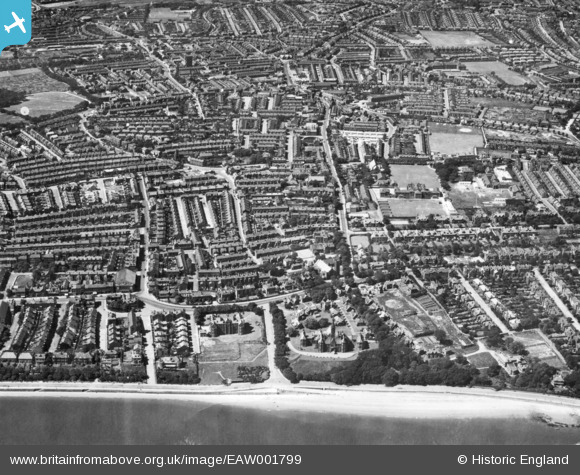
[EAW001799] Manor Road and environs, Egremont, 1946. This image has been produced from a print. |
| Reference |
EAW001799 |
| Date |
11-July-1946 |
| Link |
|
| Place name |
EGREMONT |
| Parish |
|
| District |
|
| Country |
ENGLAND |
| Easting / Northing |
331361, 392272 |
| Longitude / Latitude |
-3.0330050572478, 53.422513889047 |
| National Grid Reference |
SJ314923 |
Pins
 Church of St Columbia
Taken from the website "The History of Wallasey"
St. Columba's Church was built of red pressed brick and stood on the corner of Trafalgar Avenue at the beginning of Seabank Road. It was built during the early part of the 20th Century and took twenty years to complete before opening in 1923. The hall was under the church, as it was erected on the incline of the hill. The builder was James A. Milestone, who lived in Manor Mansions in Manor Road. It cost £4,500 to build and opened on 16th June 1904 under the care of the Revd. H.H Pitts, and became a separate parish from St. John's Church in 1922.
The church was designed in the 16th Century style by C.M. Deacon of Liverpool. It had two organs, a piano, a harmonium and a pipe organ, a really musical church!
During the war the hall was used by the Civil Defence and could be used as emergency food-kitchen.
In July 1971 by order of the Queen in Council, the two parishes of St. Mary and St. Columba were united under the incumbency of the Revd. Hugh Linn, M.A., and the present parish of St. Mary with St. Columba was formed. The last service in the building was held in 1971. The church was demolished in 1973. |

Rachel |
Wednesday 7th of February 2024 12:05:48 AM |
Primrose Pub |
andycarole |
Saturday 1st of July 2023 12:37:13 PM |
The Saddle Inn |
Norton |
Friday 21st of February 2020 06:36:21 PM |
This is area is still known as the Gaumont, after the cinema that was on this spot after the Presbyterian church was demolished |
Jess |
Wednesday 27th of December 2017 02:30:39 PM |
Mariners Park Care Home |
daveybm |
Sunday 26th of July 2015 12:01:27 PM |
Andrew Gibson House |
daveybm |
Sunday 26th of July 2015 12:00:14 PM |