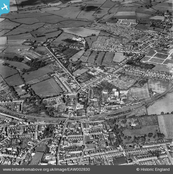
EAW002830 ENGLAND (1946). The railway station, gas works and environs, Rushden, 1946
© Copyright OpenStreetMap contributors and licensed by the OpenStreetMap Foundation. 2024. Cartography is licensed as CC BY-SA.
Nearby Images (17)
Details
| Title | [EAW002830] The railway station, gas works and environs, Rushden, 1946 |
| Reference | EAW002830 |
| Date | 30-September-1946 |
| Link | |
| Place name | RUSHDEN |
| Parish | RUSHDEN |
| District | |
| Country | ENGLAND |
| Easting / Northing | 495591, 267528 |
| Longitude / Latitude | -0.59810081162231, 52.297159874794 |
| National Grid Reference | SP956675 |
Pins
 Sparky |
Saturday 16th of September 2017 05:32:20 PM | |
 Sparky |
Saturday 16th of September 2017 05:31:53 PM | |
 John W |
Monday 4th of July 2016 04:42:02 PM | |
 Ritchiet |
Wednesday 3rd of February 2016 08:37:23 PM | |
 melgibbs |
Thursday 19th of February 2015 04:02:50 PM |


![[EAW002830] The railway station, gas works and environs, Rushden, 1946](http://britainfromabove.org.uk/sites/all/libraries/aerofilms-images/public/100x100/EAW/002/EAW002830.jpg)
![[EAW043216] The John White Impregnable Boots Ltd Works, Rushden, 1952. This image was marked by Aerofilms Ltd for photo editing.](http://britainfromabove.org.uk/sites/all/libraries/aerofilms-images/public/100x100/EAW/043/EAW043216.jpg)
![[EAW043210] The John White Impregnable Boots Ltd Works, Rushden, 1952. This image was marked by Aerofilms Ltd for photo editing.](http://britainfromabove.org.uk/sites/all/libraries/aerofilms-images/public/100x100/EAW/043/EAW043210.jpg)
![[EAW043212] The John White Impregnable Boots Ltd Works, Rushden, 1952. This image was marked by Aerofilms Ltd for photo editing.](http://britainfromabove.org.uk/sites/all/libraries/aerofilms-images/public/100x100/EAW/043/EAW043212.jpg)
![[EAW043209] The John White Impregnable Boots Ltd Works, Rushden, 1952. This image was marked by Aerofilms Ltd for photo editing.](http://britainfromabove.org.uk/sites/all/libraries/aerofilms-images/public/100x100/EAW/043/EAW043209.jpg)
![[EAW043211] The John White Impregnable Boots Ltd Works, Rushden, 1952. This image was marked by Aerofilms Ltd for photo editing.](http://britainfromabove.org.uk/sites/all/libraries/aerofilms-images/public/100x100/EAW/043/EAW043211.jpg)
![[EAW043215] The John White Impregnable Boots Ltd Works, Rushden, 1952. This image was marked by Aerofilms Ltd for photo editing.](http://britainfromabove.org.uk/sites/all/libraries/aerofilms-images/public/100x100/EAW/043/EAW043215.jpg)
![[EAW043213] The John White Impregnable Boots Ltd Works, Rushden, 1952. This image was marked by Aerofilms Ltd for photo editing.](http://britainfromabove.org.uk/sites/all/libraries/aerofilms-images/public/100x100/EAW/043/EAW043213.jpg)
![[EAW043217] The John White Impregnable Boots Ltd Works, Rushden, 1952. This image was marked by Aerofilms Ltd for photo editing.](http://britainfromabove.org.uk/sites/all/libraries/aerofilms-images/public/100x100/EAW/043/EAW043217.jpg)
![[EAW043214] The John White Impregnable Boots Ltd Works, Rushden, 1952. This image was marked by Aerofilms Ltd for photo editing.](http://britainfromabove.org.uk/sites/all/libraries/aerofilms-images/public/100x100/EAW/043/EAW043214.jpg)
![[EAW043207] Shirley Road, Rushden, 1952. This image was marked by Aerofilms Ltd for photo editing.](http://britainfromabove.org.uk/sites/all/libraries/aerofilms-images/public/100x100/EAW/043/EAW043207.jpg)
![[EAW043203] Shirley Road, Rushden, 1952. This image was marked by Aerofilms Ltd for photo editing.](http://britainfromabove.org.uk/sites/all/libraries/aerofilms-images/public/100x100/EAW/043/EAW043203.jpg)
![[EAW043202] Shirley Road, Rushden, 1952. This image was marked by Aerofilms Ltd for photo editing.](http://britainfromabove.org.uk/sites/all/libraries/aerofilms-images/public/100x100/EAW/043/EAW043202.jpg)
![[EAW043201] Shirley Road, Rushden, 1952. This image was marked by Aerofilms Ltd for photo editing.](http://britainfromabove.org.uk/sites/all/libraries/aerofilms-images/public/100x100/EAW/043/EAW043201.jpg)
![[EAW043204] Shirley Road, Rushden, 1952. This image was marked by Aerofilms Ltd for photo editing.](http://britainfromabove.org.uk/sites/all/libraries/aerofilms-images/public/100x100/EAW/043/EAW043204.jpg)
![[EAW043205] Shirley Road, Rushden, 1952. This image was marked by Aerofilms Ltd for photo editing.](http://britainfromabove.org.uk/sites/all/libraries/aerofilms-images/public/100x100/EAW/043/EAW043205.jpg)
![[EAW043206] Shirley Road, Rushden, 1952. This image was marked by Aerofilms Ltd for photo editing.](http://britainfromabove.org.uk/sites/all/libraries/aerofilms-images/public/100x100/EAW/043/EAW043206.jpg)