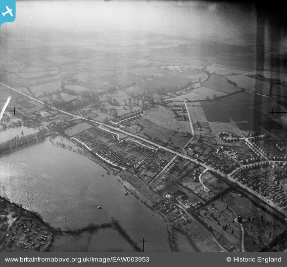
EAW003953 ENGLAND (1947). The Southern Bypass Road and flooding by North Hinksey Lane, North Hinksey Village, from the north, 1947
© Copyright OpenStreetMap contributors and licensed by the OpenStreetMap Foundation. 2024. Cartography is licensed as CC BY-SA.
Details
| Title | [EAW003953] The Southern Bypass Road and flooding by North Hinksey Lane, North Hinksey Village, from the north, 1947 |
| Reference | EAW003953 |
| Date | 20-March-1947 |
| Link | |
| Place name | NORTH HINKSEY VILLAGE |
| Parish | NORTH HINKSEY |
| District | |
| Country | ENGLAND |
| Easting / Northing | 449114, 205839 |
| Longitude / Latitude | -1.2884848298618, 51.74863753725 |
| National Grid Reference | SP491058 |
Pins
 David Brimson |
Wednesday 31st of January 2024 06:18:09 PM | |
 David Brimson |
Wednesday 31st of January 2024 06:17:27 PM |


![[EAW003953] The Southern Bypass Road and flooding by North Hinksey Lane, North Hinksey Village, from the north, 1947](http://britainfromabove.org.uk/sites/all/libraries/aerofilms-images/public/100x100/EAW/003/EAW003953.jpg)
![[EAW003977] Flooding around New Botley and environs, New Botley, from the south-west, 1947](http://britainfromabove.org.uk/sites/all/libraries/aerofilms-images/public/100x100/EAW/003/EAW003977.jpg)