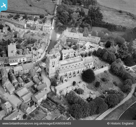
EAW008403 ENGLAND (1947). St Peter and St Paul's Church, Newport Pagnell, 1947
© Copyright OpenStreetMap contributors and licensed by the OpenStreetMap Foundation. 2024. Cartography is licensed as CC BY-SA.
Details
| Title | [EAW008403] St Peter and St Paul's Church, Newport Pagnell, 1947 |
| Reference | EAW008403 |
| Date | 20-July-1947 |
| Link | |
| Place name | NEWPORT PAGNELL |
| Parish | NEWPORT PAGNELL |
| District | |
| Country | ENGLAND |
| Easting / Northing | 487786, 243958 |
| Longitude / Latitude | -0.71864026283855, 52.086587770029 |
| National Grid Reference | SP878440 |
Pins
 Paulf1976 |
Wednesday 3rd of August 2016 01:11:24 PM | |
 melgibbs |
Wednesday 4th of March 2015 08:24:30 PM | |
 melgibbs |
Wednesday 4th of March 2015 06:23:21 PM | |
 Richard Dawson |
Saturday 27th of September 2014 01:06:05 PM | |
 Richard Dawson |
Saturday 27th of September 2014 01:04:51 PM | |
 Richard Dawson |
Thursday 11th of September 2014 06:42:31 PM | |
 Richard Dawson |
Thursday 11th of September 2014 06:41:47 PM | |
 Richard Dawson |
Tuesday 9th of September 2014 07:01:35 PM | |
 Richard Dawson |
Tuesday 9th of September 2014 07:00:06 PM | |
 Richard Dawson |
Tuesday 9th of September 2014 06:59:42 PM | |
 Richard Dawson |
Tuesday 9th of September 2014 06:58:23 PM | |
 Richard Dawson |
Tuesday 9th of September 2014 06:57:49 PM | |
Lynda Tubbs |
Wednesday 30th of April 2014 03:20:01 PM |
User Comment Contributions
 melgibbs |
Wednesday 4th of March 2015 08:26:34 PM |


![[EAW008403] St Peter and St Paul's Church, Newport Pagnell, 1947](http://britainfromabove.org.uk/sites/all/libraries/aerofilms-images/public/100x100/EAW/008/EAW008403.jpg)
![[EAW008404] St Peter and St Paul's Church, Newport Pagnell, 1947](http://britainfromabove.org.uk/sites/all/libraries/aerofilms-images/public/100x100/EAW/008/EAW008404.jpg)
![[EAW008405] St Peter and St Paul's Church, Newport Pagnell, 1947](http://britainfromabove.org.uk/sites/all/libraries/aerofilms-images/public/100x100/EAW/008/EAW008405.jpg)
![[EPW022490] Tickford End and the town centre, Newport Pagnell, from the south-east, 1928](http://britainfromabove.org.uk/sites/all/libraries/aerofilms-images/public/100x100/EPW/022/EPW022490.jpg)


