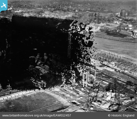
EAW012457 ENGLAND (1947). Cliff Quay Power Station (site of), Ipswich, 1947. This image has been produced from a damaged negative.
© Copyright OpenStreetMap contributors and licensed by the OpenStreetMap Foundation. 2025. Cartography is licensed as CC BY-SA.
Nearby Images (48)
Details
| Title | [EAW012457] Cliff Quay Power Station (site of), Ipswich, 1947. This image has been produced from a damaged negative. |
| Reference | EAW012457 |
| Date | 31-December-1947 |
| Link | |
| Place name | IPSWICH |
| Parish | |
| District | |
| Country | ENGLAND |
| Easting / Northing | 616995, 242194 |
| Longitude / Latitude | 1.1640392771407, 52.035197901479 |
| National Grid Reference | TM170422 |
Pins
Be the first to add a comment to this image!


![[EAW001990] Land reclamation and dock buildings under construction at Greenwich, Ipswich, 1946](http://britainfromabove.org.uk/sites/all/libraries/aerofilms-images/public/100x100/EAW/001/EAW001990.jpg)
![[EAW001984] Land reclamation and dock buildings under construction at Greenwich, Ipswich, 1946. This image has been produced from a damaged negative.](http://britainfromabove.org.uk/sites/all/libraries/aerofilms-images/public/100x100/EAW/001/EAW001984.jpg)
![[EAW001987] Land reclamation and dock buildings under construction at Greenwich, Ipswich, 1946. This image has been produced from a damaged negative.](http://britainfromabove.org.uk/sites/all/libraries/aerofilms-images/public/100x100/EAW/001/EAW001987.jpg)
![[EAW002321] Cliff Quay Power Station under construction, Ipswich, 1946](http://britainfromabove.org.uk/sites/all/libraries/aerofilms-images/public/100x100/EAW/002/EAW002321.jpg)
![[EAW027817] The Cliff Quay Power Station and Coal Yards, Ipswich, 1949. This image was marked by Aerofilms Ltd for photo editing.](http://britainfromabove.org.uk/sites/all/libraries/aerofilms-images/public/100x100/EAW/027/EAW027817.jpg)
![[EAW033191] Cliff Quay Power Station, Ipswich, 1950](http://britainfromabove.org.uk/sites/all/libraries/aerofilms-images/public/100x100/EAW/033/EAW033191.jpg)
![[EAW002319] Cliff Quay Power Station under construction, Ipswich, 1946](http://britainfromabove.org.uk/sites/all/libraries/aerofilms-images/public/100x100/EAW/002/EAW002319.jpg)
![[EAW024319] Cliff Quay Power Station, Ipswich, 1949. This image was marked by Aerofilms Ltd for photo editing.](http://britainfromabove.org.uk/sites/all/libraries/aerofilms-images/public/100x100/EAW/024/EAW024319.jpg)
![[EAW002318] Cliff Quay Power Station under construction, Ipswich, 1946](http://britainfromabove.org.uk/sites/all/libraries/aerofilms-images/public/100x100/EAW/002/EAW002318.jpg)
![[EAW001983] Land reclamation and dock buildings under construction at Greenwich, Ipswich, 1946. This image has been produced from a damaged negative.](http://britainfromabove.org.uk/sites/all/libraries/aerofilms-images/public/100x100/EAW/001/EAW001983.jpg)
![[EAW033196] Cliff Quay Power Station and Coal Yards, Ipswich, 1950](http://britainfromabove.org.uk/sites/all/libraries/aerofilms-images/public/100x100/EAW/033/EAW033196.jpg)
![[EAW024326] Cliff Quay Power Station, Ipswich, 1949. This image was marked by Aerofilms Ltd for photo editing.](http://britainfromabove.org.uk/sites/all/libraries/aerofilms-images/public/100x100/EAW/024/EAW024326.jpg)
![[EAW001989] Land reclamation and dock buildings under construction at Greenwich, Ipswich, 1946](http://britainfromabove.org.uk/sites/all/libraries/aerofilms-images/public/100x100/EAW/001/EAW001989.jpg)
![[EAW033194] Cliff Quay Power Station, Ipswich, 1950](http://britainfromabove.org.uk/sites/all/libraries/aerofilms-images/public/100x100/EAW/033/EAW033194.jpg)
![[EAW008089] Cliff Quay Power Station under construction, Ipswich, 1947](http://britainfromabove.org.uk/sites/all/libraries/aerofilms-images/public/100x100/EAW/008/EAW008089.jpg)
![[EAW033193] Cliff Quay Power Station and Coal Yards, Ipswich, 1950](http://britainfromabove.org.uk/sites/all/libraries/aerofilms-images/public/100x100/EAW/033/EAW033193.jpg)
![[EAW033199] Cliff Quay Power Station and Coal Yards, Ipswich, 1950](http://britainfromabove.org.uk/sites/all/libraries/aerofilms-images/public/100x100/EAW/033/EAW033199.jpg)
![[EAW024335] Cliff Quay Power Station, Ipswich, 1949](http://britainfromabove.org.uk/sites/all/libraries/aerofilms-images/public/100x100/EAW/024/EAW024335.jpg)
![[EAW020670] Building work on the Cliff Quay Power Station and surrounding construction site, Ipswich, 1948](http://britainfromabove.org.uk/sites/all/libraries/aerofilms-images/public/100x100/EAW/020/EAW020670.jpg)
![[EAW020668] Cliff Quay Power Station under construction, Ipswich, 1948. This image was marked by Aerofilms Ltd for photo editing.](http://britainfromabove.org.uk/sites/all/libraries/aerofilms-images/public/100x100/EAW/020/EAW020668.jpg)
![[EAW008088] Cliff Quay Power Station under construction, Ipswich, 1947](http://britainfromabove.org.uk/sites/all/libraries/aerofilms-images/public/100x100/EAW/008/EAW008088.jpg)
![[EAW017572] Cliff Quay Power Station under construction, Ipswich, 1948](http://britainfromabove.org.uk/sites/all/libraries/aerofilms-images/public/100x100/EAW/017/EAW017572.jpg)
![[EAW017579] Cliff Quay Power Station under construction, Ipswich, 1948. This image has been produced from a damaged negative.](http://britainfromabove.org.uk/sites/all/libraries/aerofilms-images/public/100x100/EAW/017/EAW017579.jpg)
![[EAW017578] Cliff Quay Power Station under construction and environs, Ipswich, 1948](http://britainfromabove.org.uk/sites/all/libraries/aerofilms-images/public/100x100/EAW/017/EAW017578.jpg)
![[EAW002323] Cliff Quay Power Station under construction, Ipswich, from the south-west, 1946](http://britainfromabove.org.uk/sites/all/libraries/aerofilms-images/public/100x100/EAW/002/EAW002323.jpg)
![[EAW017569] Cliff Quay Power Station under construction, Ipswich, 1948. This image has been produced from a print.](http://britainfromabove.org.uk/sites/all/libraries/aerofilms-images/public/100x100/EAW/017/EAW017569.jpg)
![[EAW027821] The Cliff Quay Power Station, Ipswich, 1949. This image was marked by Aerofilms Ltd for photo editing.](http://britainfromabove.org.uk/sites/all/libraries/aerofilms-images/public/100x100/EAW/027/EAW027821.jpg)
![[EAW027814] The Cliff Quay Power Station, Ipswich, 1949. This image was marked by Aerofilms Ltd for photo editing.](http://britainfromabove.org.uk/sites/all/libraries/aerofilms-images/public/100x100/EAW/027/EAW027814.jpg)
![[EAW017570] Cliff Quay Power Station under construction and environs, Ipswich, 1948](http://britainfromabove.org.uk/sites/all/libraries/aerofilms-images/public/100x100/EAW/017/EAW017570.jpg)
![[EAW024338] Cliff Quay Power Station, Ipswich, 1949](http://britainfromabove.org.uk/sites/all/libraries/aerofilms-images/public/100x100/EAW/024/EAW024338.jpg)
![[EAW024336] Cliff Quay Power Station, Ipswich, 1949](http://britainfromabove.org.uk/sites/all/libraries/aerofilms-images/public/100x100/EAW/024/EAW024336.jpg)
![[EAW008082] Cliff Quay Power Station under construction, Ipswich, 1947. This image was marked by Aerofilms Ltd for photo editing.](http://britainfromabove.org.uk/sites/all/libraries/aerofilms-images/public/100x100/EAW/008/EAW008082.jpg)
![[EAW024332] Cliff Quay Power Station and Greenwich, Ipswich, from the south-west, 1949](http://britainfromabove.org.uk/sites/all/libraries/aerofilms-images/public/100x100/EAW/024/EAW024332.jpg)
![[EAW002326] Cliff Quay Power Station under construction, Ipswich, from the south-west, 1946](http://britainfromabove.org.uk/sites/all/libraries/aerofilms-images/public/100x100/EAW/002/EAW002326.jpg)
![[EAW027825] The Cliff Quay Power Station and Coal Yards, Ipswich, 1949. This image was marked by Aerofilms Ltd for photo editing.](http://britainfromabove.org.uk/sites/all/libraries/aerofilms-images/public/100x100/EAW/027/EAW027825.jpg)
![[EAW002327] Cliff Quay Power Station under construction, Ipswich, from the south-west, 1946](http://britainfromabove.org.uk/sites/all/libraries/aerofilms-images/public/100x100/EAW/002/EAW002327.jpg)
![[EAW017565] Cliff Quay Power Station under construction, Ipswich, 1948. This image has been produced from a damaged negative.](http://britainfromabove.org.uk/sites/all/libraries/aerofilms-images/public/100x100/EAW/017/EAW017565.jpg)
![[EAW033200] Cliff Quay Power Station and Coal Yards, Ipswich, 1950](http://britainfromabove.org.uk/sites/all/libraries/aerofilms-images/public/100x100/EAW/033/EAW033200.jpg)
![[EAW027822] The Cliff Quay Power Station and Coal Yards, Ipswich, 1949](http://britainfromabove.org.uk/sites/all/libraries/aerofilms-images/public/100x100/EAW/027/EAW027822.jpg)
![[EAW017568] Cliff Quay Power Station under construction, Ipswich, 1948](http://britainfromabove.org.uk/sites/all/libraries/aerofilms-images/public/100x100/EAW/017/EAW017568.jpg)
![[EAW027823] The Cliff Quay Power Station and Coal Yards, Ipswich, 1949. This image was marked by Aerofilms Ltd for photo editing.](http://britainfromabove.org.uk/sites/all/libraries/aerofilms-images/public/100x100/EAW/027/EAW027823.jpg)
![[EAW008078] Cliff Quay Power Station under construction, Ipswich, 1947. This image was marked by Aerofilms Ltd for photo editing.](http://britainfromabove.org.uk/sites/all/libraries/aerofilms-images/public/100x100/EAW/008/EAW008078.jpg)
![[EAW027819] The Cliff Quay Power Station and Coal Yards, Ipswich, 1949. This image was marked by Aerofilms Ltd for photo editing.](http://britainfromabove.org.uk/sites/all/libraries/aerofilms-images/public/100x100/EAW/027/EAW027819.jpg)
![[EAW027812] The Cliff Quay Power Station and Coal Yards, Ipswich, 1949. This image was marked by Aerofilms Ltd for photo editing.](http://britainfromabove.org.uk/sites/all/libraries/aerofilms-images/public/100x100/EAW/027/EAW027812.jpg)
![[EAW008084] Cliff Quay Power Station under construction, Ipswich, 1947](http://britainfromabove.org.uk/sites/all/libraries/aerofilms-images/public/100x100/EAW/008/EAW008084.jpg)
![[EAW033198] Cliff Quay Power Station and Coal Yards, Ipswich, 1950](http://britainfromabove.org.uk/sites/all/libraries/aerofilms-images/public/100x100/EAW/033/EAW033198.jpg)
![[EAW008083] Cliff Quay Power Station under construction, Ipswich, 1947](http://britainfromabove.org.uk/sites/all/libraries/aerofilms-images/public/100x100/EAW/008/EAW008083.jpg)
![[EAW002324] Cliff Quay Power Station under construction, Ipswich, from the south-west, 1946](http://britainfromabove.org.uk/sites/all/libraries/aerofilms-images/public/100x100/EAW/002/EAW002324.jpg)