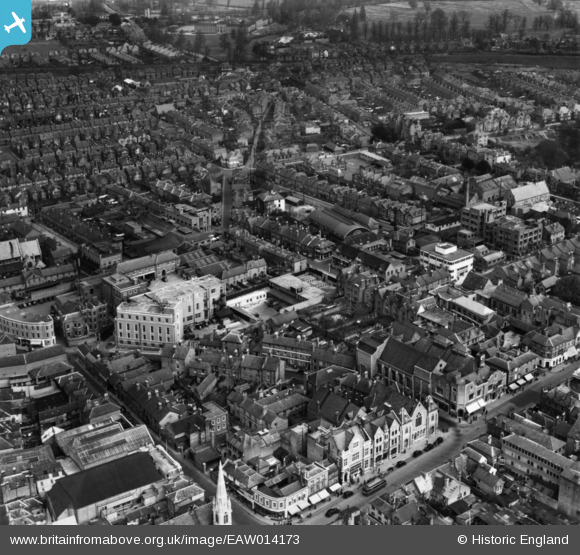
EAW014173 ENGLAND (1948). The Telephone Exchange, Lepale Road and environs, Guildford, 1948. This image has been produced from a print marked by Aerofilms Ltd for photo editing.
© Copyright OpenStreetMap contributors and licensed by the OpenStreetMap Foundation. 2025. Cartography is licensed as CC BY-SA.
Nearby Images (18)
Details
| Title | [EAW014173] The Telephone Exchange, Lepale Road and environs, Guildford, 1948. This image has been produced from a print marked by Aerofilms Ltd for photo editing. |
| Reference | EAW014173 |
| Date | 7-April-1948 |
| Link | |
| Place name | GUILDFORD |
| Parish | |
| District | |
| Country | ENGLAND |
| Easting / Northing | 499682, 149743 |
| Longitude / Latitude | -0.57193823877363, 51.237635465898 |
| National Grid Reference | SU997497 |
Pins
Be the first to add a comment to this image!


![[EAW014173] The Telephone Exchange, Lepale Road and environs, Guildford, 1948. This image has been produced from a print marked by Aerofilms Ltd for photo editing.](http://britainfromabove.org.uk/sites/all/libraries/aerofilms-images/public/100x100/EAW/014/EAW014173.jpg)
![[EAW014169] The Telephone Exchange, Leapale Lane and environs, Guildford, 1948. This image has been produced from a print marked by Aerofilms Ltd for photo editing.](http://britainfromabove.org.uk/sites/all/libraries/aerofilms-images/public/100x100/EAW/014/EAW014169.jpg)
![[EAW014176] The Telephone Exchange, The Bars and environs, Guildford, 1948. This image has been produced from a print marked by Aerofilms Ltd for photo editing.](http://britainfromabove.org.uk/sites/all/libraries/aerofilms-images/public/100x100/EAW/014/EAW014176.jpg)
![[EAW014170] Sandfield Terrace and environs, Guildford, 1948. This image has been produced from a print marked by Aerofilms Ltd for photo editing.](http://britainfromabove.org.uk/sites/all/libraries/aerofilms-images/public/100x100/EAW/014/EAW014170.jpg)
![[EAW014168] North Street, Lepale Road and environs, Guildford, 1948. This image has been produced from a print marked by Aerofilms Ltd for photo editing.](http://britainfromabove.org.uk/sites/all/libraries/aerofilms-images/public/100x100/EAW/014/EAW014168.jpg)
![[EAW014180] The Guildford and District Co-operative Society Stores on Haydon Place and environs, Guildford, 1948](http://britainfromabove.org.uk/sites/all/libraries/aerofilms-images/public/100x100/EAW/014/EAW014180.jpg)
![[EAW014179] The Sorting Office, Guildford and District Co-operative Society Stores and environs, Guildford, 1948. This image has been produced from a print.](http://britainfromabove.org.uk/sites/all/libraries/aerofilms-images/public/100x100/EAW/014/EAW014179.jpg)
![[EAW014171] Sandfield Terrace and North Place, Guildford, 1948. This image has been produced from a print marked by Aerofilms Ltd for photo editing.](http://britainfromabove.org.uk/sites/all/libraries/aerofilms-images/public/100x100/EAW/014/EAW014171.jpg)
![[EAW014174] The Guildford and District Co-operative Society Stores on Haydon Place and environs, Guildford, 1948. This image has been produced from a print marked by Aerofilms Ltd for photo editing.](http://britainfromabove.org.uk/sites/all/libraries/aerofilms-images/public/100x100/EAW/014/EAW014174.jpg)
![[EAW014172] North Street, Leapale Road and environs, Guildford, 1948. This image has been produced from a print marked by Aerofilms Ltd for photo editing.](http://britainfromabove.org.uk/sites/all/libraries/aerofilms-images/public/100x100/EAW/014/EAW014172.jpg)
![[EAW014178] North Street, Leapale Road and environs, Guildford, 1948. This image has been produced from a print marked by Aerofilms Ltd for photo editing.](http://britainfromabove.org.uk/sites/all/libraries/aerofilms-images/public/100x100/EAW/014/EAW014178.jpg)
![[EAW022668] Sandfield Terrace and the town centre, Guildford, 1949. This image has been produced from a print.](http://britainfromabove.org.uk/sites/all/libraries/aerofilms-images/public/100x100/EAW/022/EAW022668.jpg)
![[EPW054834] The Garstang Creameries Depot off The Bars and the surrounding area, Guildford, 1937. This image has been produced from a copy-negative.](http://britainfromabove.org.uk/sites/all/libraries/aerofilms-images/public/100x100/EPW/054/EPW054834.jpg)
![[EPW054835] The Garstang Creameries Depot off The Bars and the surrounding area, Guildford, 1937. This image has been produced from a print.](http://britainfromabove.org.uk/sites/all/libraries/aerofilms-images/public/100x100/EPW/054/EPW054835.jpg)
![[EPW016875] North Street and the town centre, Guildford, 1926](http://britainfromabove.org.uk/sites/all/libraries/aerofilms-images/public/100x100/EPW/016/EPW016875.jpg)
![[EPW054836] The Garstang Creameries Depot off The Bars and the surrounding area, Guildford, 1937. This image has been produced from a copy-negative.](http://britainfromabove.org.uk/sites/all/libraries/aerofilms-images/public/100x100/EPW/054/EPW054836.jpg)
![[EPW022662] Holy Trinity Church, Abbott's Hospital and environs, Guildford, 1928. This image has been produced from a copy-negative.](http://britainfromabove.org.uk/sites/all/libraries/aerofilms-images/public/100x100/EPW/022/EPW022662.jpg)
![[EPW016874] The cattle market and environs, Guildford, 1926](http://britainfromabove.org.uk/sites/all/libraries/aerofilms-images/public/100x100/EPW/016/EPW016874.jpg)