
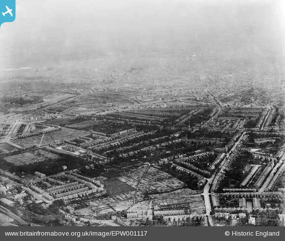
EPW001117 ENGLAND (1920). The northern area of the city, Birmingham, from the north-west, 1920
© Copyright OpenStreetMap contributors and licensed by the OpenStreetMap Foundation. 2025. Cartography is licensed as CC BY-SA.
Details
| Title | [EPW001117] The northern area of the city, Birmingham, from the north-west, 1920 |
| Reference | EPW001117 |
| Date | May-1920 |
| Link | |
| Place name | BIRMINGHAM |
| Parish | |
| District | |
| Country | ENGLAND |
| Easting / Northing | 406560, 290514 |
| Longitude / Latitude | -1.9033273647133, 52.512110187273 |
| National Grid Reference | SP066905 |
Pins
 Bart |
Wednesday 8th of December 2021 12:18:04 PM | |
Banjo |
Saturday 31st of July 2021 05:28:12 PM | |
Ruralranter |
Sunday 18th of July 2021 10:29:05 PM | |
Ruralranter |
Sunday 18th of July 2021 10:26:33 PM | |
Ruralranter |
Sunday 18th of July 2021 10:24:53 PM | |
Ruralranter |
Sunday 18th of July 2021 10:23:03 PM | |
Ruralranter |
Sunday 18th of July 2021 10:22:00 PM | |
Ruralranter |
Sunday 18th of July 2021 10:10:25 PM | |
Ruralranter |
Sunday 18th of July 2021 10:05:56 PM | |
Griffin |
Thursday 15th of October 2020 05:18:51 PM | |
Griffin |
Thursday 15th of October 2020 05:15:04 PM | |
Griffin |
Thursday 15th of October 2020 05:09:16 PM | |
Griffin |
Thursday 15th of October 2020 04:57:02 PM | |
Griffin |
Thursday 15th of October 2020 04:48:37 PM | |
Griffin |
Thursday 15th of October 2020 04:45:52 PM | |
Griffin |
Thursday 15th of October 2020 04:42:28 PM | |
Griffin |
Thursday 15th of October 2020 04:38:26 PM | |
Griffin |
Thursday 15th of October 2020 04:35:57 PM | |
Griffin |
Thursday 15th of October 2020 04:34:33 PM | |
Sasha506 |
Wednesday 9th of March 2016 08:37:53 AM | |
Sasha506 |
Wednesday 9th of March 2016 08:32:26 AM | |
Rekrap |
Wednesday 17th of October 2012 09:09:40 AM | |
Rekrap |
Wednesday 17th of October 2012 09:09:06 AM | |
Rekrap |
Wednesday 17th of October 2012 09:08:22 AM | |
Rekrap |
Wednesday 17th of October 2012 09:07:40 AM | |
Rekrap |
Wednesday 17th of October 2012 09:07:17 AM | |
Rekrap |
Wednesday 17th of October 2012 09:06:42 AM | |
 ..AAAston Lad |
Monday 27th of August 2012 05:12:00 PM | |
..AAAston Lad |
Monday 27th of August 2012 05:10:34 PM | |
..AAAston Lad |
Monday 27th of August 2012 05:09:55 PM | |
Tony D |
Saturday 7th of July 2012 12:33:20 AM | |
TonyW1960 |
Friday 29th of June 2012 10:15:58 PM |
User Comment Contributions
Dear all, Your contribution are great; we’ve reviewed the comments and pins and thanks to your help we can update the catalogue. The revised record with the correct location will appear here in due course. Yours, Katy Britain from Above Cataloguing Team Leader |
Katy Whitaker |
Tuesday 23rd of October 2012 09:56:21 AM |
The photo is likely to have been taken from above the railway line forming the boundary of Perry Hall Playing Fields on an approximate bearing of 120 degrees, in the lower centre Wellington Road appears from out of shot and in the centre distance are the Nechells Gas Holders. Wellington Road extends left and up to the junction of Birchfield Road and continues across as Aston Lane. On Birchfield Road can be seen the distinctive Birchfield Cinema and further on the Holy Trinity Parish Church at the corner of Birchfield Road and Trinity Road just left of centre of the photo, the road then curves towards Newtown. The small group of buildings within the light coloured rectangle will be Canterbury Road School and the adjacent taller building being a police station. In the lower left corner the railway platform is that of Perry Barr Station and on the centre left hand side the triangular development is bounded by The Broadway, Davey Road and Normandy Road. Further up on the left is Aston Park containing Aston Hall. |
KB |
Thursday 12th of July 2012 01:41:45 PM |
This looks like Aston Birmingham, viewed from Perry Barr. Zoom in towards top, Nechells gas holders. |
Paulie |
Monday 9th of July 2012 08:43:57 PM |
I think it's Birchfield in the West Midlands, viewed from the northwest. Appears to be Aston Hall on the left, and the station would by Perry Barr. |
Tony D |
Friday 6th of July 2012 03:50:50 PM |