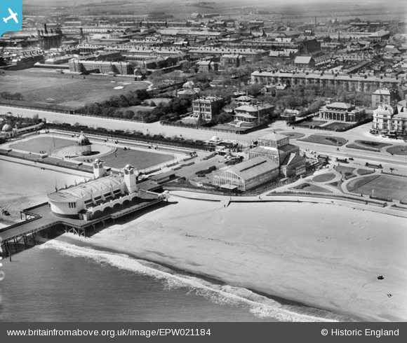
EPW021184 ENGLAND (1928). Wellington Pier and the seafront, Great Yarmouth, 1928
© Copyright OpenStreetMap contributors and licensed by the OpenStreetMap Foundation. 2024. Cartography is licensed as CC BY-SA.
Nearby Images (5)
Details
| Title | [EPW021184] Wellington Pier and the seafront, Great Yarmouth, 1928 |
| Reference | EPW021184 |
| Date | May-1928 |
| Link | |
| Place name | GREAT YARMOUTH |
| Parish | |
| District | |
| Country | ENGLAND |
| Easting / Northing | 653135, 306719 |
| Longitude / Latitude | 1.7384259466255, 52.598826920742 |
| National Grid Reference | TG531067 |
Pins
 swanny1958 |
Wednesday 11th of July 2012 09:26:47 PM |


![[EPW021184] Wellington Pier and the seafront, Great Yarmouth, 1928](http://britainfromabove.org.uk/sites/all/libraries/aerofilms-images/public/100x100/EPW/021/EPW021184.jpg)
![[EAW005069] Wellington Pier, the Winter Gardens and Wellington Gardens, Great Yarmouth, 1947](http://britainfromabove.org.uk/sites/all/libraries/aerofilms-images/public/100x100/EAW/005/EAW005069.jpg)
![[EAW026626] Wellington Pier, the Winter Gardens and the town, Great Yarmouth, from the east, 1949](http://britainfromabove.org.uk/sites/all/libraries/aerofilms-images/public/100x100/EAW/026/EAW026626.jpg)
![[EPW008064] St Nicholas's Hospital and environs, Great Yarmouth, from the east, 1922](http://britainfromabove.org.uk/sites/all/libraries/aerofilms-images/public/100x100/EPW/008/EPW008064.jpg)
![[EPW016562] The Winter Gardens, Nelson Road South and environs, Great Yarmouth, 1926](http://britainfromabove.org.uk/sites/all/libraries/aerofilms-images/public/100x100/EPW/016/EPW016562.jpg)