
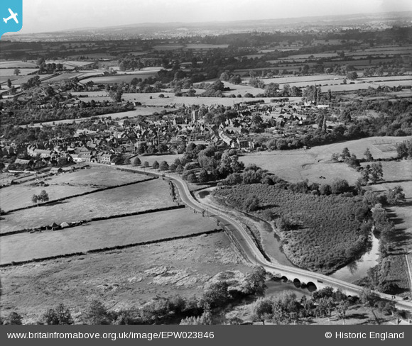
EPW023846 ENGLAND (1928). The Town, Alcester, from the south-east, 1928
© Copyright OpenStreetMap contributors and licensed by the OpenStreetMap Foundation. 2025. Cartography is licensed as CC BY-SA.
Details
| Title | [EPW023846] The Town, Alcester, from the south-east, 1928 |
| Reference | EPW023846 |
| Date | September-1928 |
| Link | |
| Place name | ALCESTER |
| Parish | ALCESTER |
| District | |
| Country | ENGLAND |
| Easting / Northing | 409248, 257046 |
| Longitude / Latitude | -1.8646379704432, 52.211154964204 |
| National Grid Reference | SP092570 |
Pins
 Class31 |
Sunday 31st of August 2014 09:11:42 PM | |
 Smudger |
Monday 23rd of December 2013 04:44:41 PM | |
Class31 |
Tuesday 31st of July 2012 03:11:56 PM | |
John |
Thursday 5th of July 2012 08:20:12 AM | |
EastMarple1 |
Monday 2nd of July 2012 12:46:36 PM | |
Yes,it's the branch from Bearley (on the Stratford to Hatton line),to Alcester (on the Evesham to Redditch line). |
 clippedwings |
Thursday 16th of August 2012 10:31:43 PM |
Actually it is the Barnt Green - Redditch - Evesham - Ashchurch line. Closed to passengers in 1962 between Evesham and Redditch due to the "condition of the track". It had been a useful alternative route for freight trains to avoid climbing the Lickey Incline. |
Smudger |
Monday 23rd of December 2013 04:42:11 PM |
EastMarple1 |
Monday 2nd of July 2012 12:43:36 PM | |
EastMarple1 |
Monday 2nd of July 2012 12:42:29 PM | |
EastMarple1 |
Monday 2nd of July 2012 12:39:34 PM | |
EastMarple1 |
Friday 29th of June 2012 02:19:20 PM | |
EastMarple1 |
Friday 29th of June 2012 02:17:06 PM | |
St. Nicholas Church Alcester |
Class31 |
Wednesday 4th of July 2012 07:07:51 PM |
EastMarple1 |
Friday 29th of June 2012 02:16:01 PM | |
EastMarple1 |
Friday 29th of June 2012 01:57:18 PM | |
EastMarple1 |
Friday 29th of June 2012 01:55:44 PM | |
Timber Framed building in Malt Mill Lane |
Class31 |
Wednesday 4th of July 2012 07:22:59 PM |
EastMarple1 |
Friday 29th of June 2012 01:54:39 PM | |
Gas storage at Gas House Lane |
Class31 |
Wednesday 4th of July 2012 07:10:41 PM |
BigglesH |
Wednesday 27th of June 2012 06:36:36 PM | |
Bridge over River Arrow at Oversley Green |
Class31 |
Wednesday 4th of July 2012 07:09:16 PM |
Think this is where River Alne (on right of picture) runs into the R.Arrow flowing out of Alcester |
John |
Thursday 5th of July 2012 08:24:51 AM |

User Comment Contributions
 St. Nicholas' Church, Alcester, 23/08/2014 |
Class31 |
Sunday 31st of August 2014 09:13:33 PM |
This is a shot of Alcester taken from Oversley Green looking in a North Westerly direction. The River Arrow is in the foreground. In alcester we see the tower of St. Nicholas Church. In line with the church is a half timbered building in Malt House Lane. Everything fits. |
Class31 |
Wednesday 24th of October 2012 10:47:39 AM |
Definitely Alcester, I lived there from 1980 until 1998. Lots of well restored timber-framed buildings,the oldest inhabited one at that time was a 13th century Cruck-cottage. Well worth a visit. |
clippedwings |
Tuesday 14th of August 2012 10:20:09 PM |
Lovely job, thanks Class 31 - we'll update the catalogue and post the correct location data here in due course. The Register entry just says "Gen:view"! Yours, Katy Britain from Above Cataloguing Team Leader |
Katy Whitaker |
Wednesday 24th of October 2012 10:47:39 AM |