
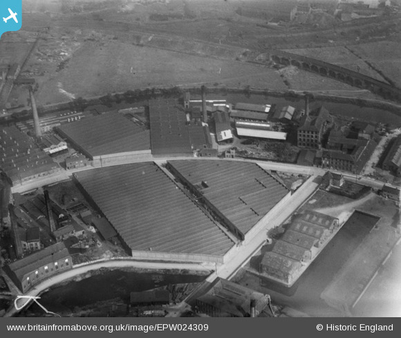
EPW024309 ENGLAND (1928). Queen's Woollen Mills and the Aire and Calder Navigation Wharf, Dewsbury, 1928
© Copyright OpenStreetMap contributors and licensed by the OpenStreetMap Foundation. 2025. Cartography is licensed as CC BY-SA.
Details
| Title | [EPW024309] Queen's Woollen Mills and the Aire and Calder Navigation Wharf, Dewsbury, 1928 |
| Reference | EPW024309 |
| Date | September-1928 |
| Link | |
| Place name | DEWSBURY |
| Parish | |
| District | |
| Country | ENGLAND |
| Easting / Northing | 424966, 421032 |
| Longitude / Latitude | -1.6219393296231, 53.684918833695 |
| National Grid Reference | SE250210 |
Pins
 Savile Mills |
Tuesday 16th of November 2021 03:39:52 PM | |
 Michael |
Saturday 26th of October 2019 03:00:11 PM | |
Michael |
Friday 18th of October 2019 03:39:35 PM | |
Michael |
Friday 18th of October 2019 03:38:58 PM |
User Comment Contributions
Wilkido is quite right,this shows the basin of the Calder and Hebble Dewsbury spur.The curving road is Mill Street East with the Headfield Viaduct carrying the railway over the River Calder. |
 Cabby |
Wednesday 11th of July 2012 05:52:26 PM |
Actually should be the Calder and Hebble Navigation |
wilkido |
Wednesday 27th of June 2012 07:18:20 AM |