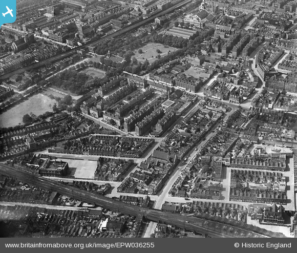
EPW036255 ENGLAND (1931). Bethnal Green Gardens and the Bethnal Green Estate, Bethnal Green, 1931
© Copyright OpenStreetMap contributors and licensed by the OpenStreetMap Foundation. 2024. Cartography is licensed as CC BY-SA.
Nearby Images (7)
Details
| Title | [EPW036255] Bethnal Green Gardens and the Bethnal Green Estate, Bethnal Green, 1931 |
| Reference | EPW036255 |
| Date | August-1931 |
| Link | |
| Place name | BETHNAL GREEN |
| Parish | |
| District | |
| Country | ENGLAND |
| Easting / Northing | 535242, 182656 |
| Longitude / Latitude | -0.050239271987719, 51.526119984872 |
| National Grid Reference | TQ352827 |
Pins
 NickPStanton |
Monday 26th of October 2020 08:25:15 PM | |
 TinyTim |
Thursday 30th of July 2015 05:19:04 PM | |
 TinyTim |
Thursday 30th of July 2015 05:14:50 PM | |
 billyfern |
Sunday 29th of June 2014 07:51:29 PM | |
 billyfern |
Sunday 29th of June 2014 07:50:54 PM | |
 billyfern |
Sunday 29th of June 2014 07:50:36 PM | |
 billyfern |
Sunday 29th of June 2014 07:50:16 PM | |
 teebee |
Saturday 7th of June 2014 06:28:44 PM | |
 Trebor |
Sunday 16th of December 2012 06:02:02 AM | |
 Trebor |
Sunday 16th of December 2012 06:01:23 AM |


![[EPW036255] Bethnal Green Gardens and the Bethnal Green Estate, Bethnal Green, 1931](http://britainfromabove.org.uk/sites/all/libraries/aerofilms-images/public/100x100/EPW/036/EPW036255.jpg)
![[EPW036261] The Bethnal Green Estate and environs, Bethnal Green, 1931](http://britainfromabove.org.uk/sites/all/libraries/aerofilms-images/public/100x100/EPW/036/EPW036261.jpg)
![[EPW036257] The Bethnal Green Estate and environs, Bethnal Green, 1931](http://britainfromabove.org.uk/sites/all/libraries/aerofilms-images/public/100x100/EPW/036/EPW036257.jpg)
![[EPW036259] Bethnal Green Gardens, the Bethnal Green Estate and environs, Bethnal Green, 1931](http://britainfromabove.org.uk/sites/all/libraries/aerofilms-images/public/100x100/EPW/036/EPW036259.jpg)
![[EPW036258] The Bethnal Green Estate and environs, Bethnal Green, 1931](http://britainfromabove.org.uk/sites/all/libraries/aerofilms-images/public/100x100/EPW/036/EPW036258.jpg)
![[EPW036256] Bethnal Green Gardens and the Bethnal Green Estate, Bethnal Green, 1931](http://britainfromabove.org.uk/sites/all/libraries/aerofilms-images/public/100x100/EPW/036/EPW036256.jpg)
![[EPW036260] The Bethnal Green Estate and environs, Bethnal Green, 1931](http://britainfromabove.org.uk/sites/all/libraries/aerofilms-images/public/100x100/EPW/036/EPW036260.jpg)