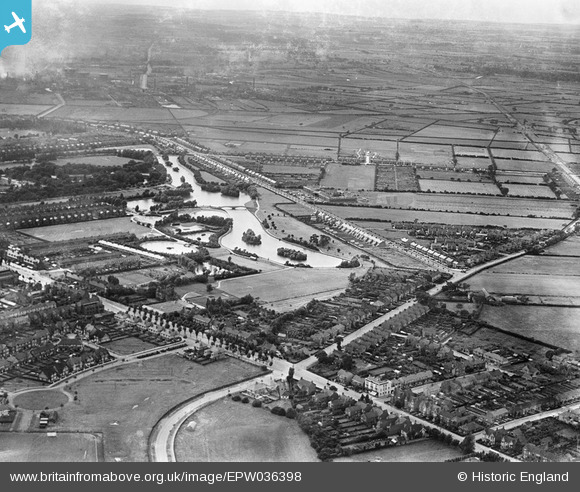
EPW036398 ENGLAND (1931). The East Park Boating Lake and environs, Kingston upon Hull, from the east, 1931
© Copyright OpenStreetMap contributors and licensed by the OpenStreetMap Foundation. 2024. Cartography is licensed as CC BY-SA.
Details
| Title | [EPW036398] The East Park Boating Lake and environs, Kingston upon Hull, from the east, 1931 |
| Reference | EPW036398 |
| Date | August-1931 |
| Link | |
| Place name | KINGSTON UPON HULL |
| Parish | |
| District | |
| Country | ENGLAND |
| Easting / Northing | 512790, 431382 |
| Longitude / Latitude | -0.28864322128303, 53.766337779119 |
| National Grid Reference | TA128314 |
Pins
 kj5050 |
Saturday 7th of January 2017 10:54:05 AM | |
 kj5050 |
Saturday 7th of January 2017 10:49:19 AM | |
 CartoonHead |
Saturday 19th of September 2015 10:12:43 AM | |
 John Wass |
Saturday 1st of August 2015 04:11:52 PM | |
 Russell |
Tuesday 12th of May 2015 04:50:52 PM | |
 Russell |
Tuesday 12th of May 2015 04:49:02 PM | |
 Russell |
Tuesday 12th of May 2015 04:47:56 PM | |
 Russell |
Tuesday 12th of May 2015 04:46:33 PM | |
 John Wass |
Friday 3rd of April 2015 08:28:48 PM | |
 John Wass |
Wednesday 24th of September 2014 03:18:03 PM | |
 John Wass |
Tuesday 19th of August 2014 03:17:27 PM | |
 OldShagnasty |
Thursday 24th of July 2014 05:58:07 PM | |
 OldShagnasty |
Thursday 24th of July 2014 05:57:27 PM | |
 John Wass |
Friday 20th of June 2014 04:11:37 PM | |
 rachelst |
Monday 21st of October 2013 04:46:45 PM | |
 Melm |
Wednesday 23rd of January 2013 10:57:37 AM |


 1932.jpg?itok=oIbVjCp7)