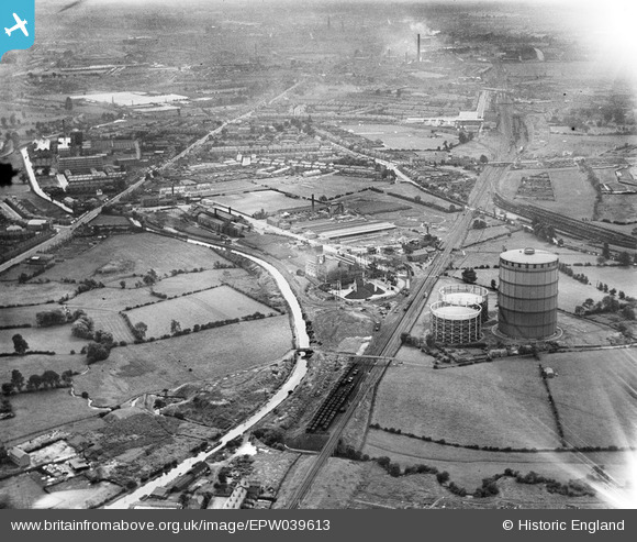
EPW039613 ENGLAND (1932). Coventry Corporation Gas Works and environs, Longford, from the north, 1932
© Copyright OpenStreetMap contributors and licensed by the OpenStreetMap Foundation. 2025. Cartography is licensed as CC BY-SA.
Details
| Title | [EPW039613] Coventry Corporation Gas Works and environs, Longford, from the north, 1932 |
| Reference | EPW039613 |
| Date | August-1932 |
| Link | |
| Place name | LONGFORD |
| Parish | |
| District | |
| Country | ENGLAND |
| Easting / Northing | 434681, 283740 |
| Longitude / Latitude | -1.4896330283778, 52.450143534492 |
| National Grid Reference | SP347837 |
Pins
 BBCoaster |
Monday 8th of January 2024 03:46:30 PM | |
 Tezzacov |
Saturday 8th of February 2014 04:44:22 PM | |
 Tezzacov |
Saturday 8th of February 2014 04:42:47 PM | |
 Tezzacov |
Thursday 30th of May 2013 05:08:47 PM | |
 Tezzacov |
Thursday 30th of May 2013 02:01:24 PM | |
 Tezzacov |
Thursday 30th of May 2013 11:06:39 AM | |
 Tezzacov |
Thursday 30th of May 2013 11:03:33 AM | |
 Tezzacov |
Thursday 30th of May 2013 10:36:17 AM | |
 Tezzacov |
Thursday 30th of May 2013 10:27:57 AM | |
 Tezzacov |
Thursday 30th of May 2013 10:24:58 AM | |
 Tezzacov |
Thursday 30th of May 2013 10:22:35 AM |

