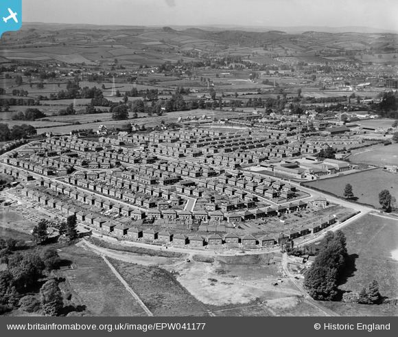
EPW041177 ENGLAND (1933). Housing off Burnthouse Lane and environs, Exeter, from the north-east, 1933
© Copyright OpenStreetMap contributors and licensed by the OpenStreetMap Foundation. 2025. Cartography is licensed as CC BY-SA.
Details
Title | [EPW041177] Housing off Burnthouse Lane and environs, Exeter, from the north-east, 1933 |
Reference | EPW041177 |
Date | May-1933 |
Link | |
Place name | EXETER |
Parish | |
District | |
Country | ENGLAND |
Easting / Northing | 294137, 91303 |
Longitude / Latitude | -3.4995598247347, 50.711134594188 |
National Grid Reference | SX941913 |
Pins
Milton Road |
Allen T |
Friday 1st of August 2014 07:20:42 PM |
Laurel Road |
Allen T |
Friday 1st of August 2014 07:18:33 PM |
Laburnum Road |
Allen T |
Friday 1st of August 2014 07:17:55 PM |
Holly Road |
Allen T |
Friday 1st of August 2014 07:17:00 PM |
Shakespeare Road |
Allen T |
Friday 1st of August 2014 07:09:06 PM |
Hawthorn Road |
Allen T |
Friday 1st of August 2014 07:08:02 PM |
Hawthorn Road |
Allen T |
Friday 1st of August 2014 07:07:17 PM |
Briar Crescent |
Allen T |
Friday 1st of August 2014 07:06:09 PM |
Chestnut Ave |
Allen T |
Friday 1st of August 2014 07:04:29 PM |
It was as a result of the nationwide 1920's and 1930's urban sprawl that the post-war 1947 Town and Country Planning Act was passed. |
Allen T |
Sunday 19th of May 2013 12:42:12 AM |
Spenser Avenue |
Allen T |
Sunday 19th of May 2013 12:39:02 AM |
WG Rice General Store which served the whole area and must have been a profitable shop. A very bright summer's day the window blind is out. |
Allen T |
Sunday 19th of May 2013 12:38:10 AM |
The Dolphin Inn |
Allen T |
Sunday 19th of May 2013 12:35:46 AM |
Footings for new house construction. |
Allen T |
Sunday 19th of May 2013 12:33:34 AM |
Piles of paving slabs. |
Allen T |
Sunday 19th of May 2013 12:28:37 AM |
End of pavement being laid. |
Allen T |
Sunday 19th of May 2013 12:27:03 AM |
For some reason all over the estate the houses don't follow the same symmetrical frontal building line and jut out and back. Why is this I wonder? |
Allen T |
Sunday 19th of May 2013 12:23:34 AM |
None of these houses are occupied. The road and pavement is being put in and the pavement slabs are stacked ready to be laid. |
Allen T |
Sunday 19th of May 2013 12:20:28 AM |
Horse pulling a cart or buggy. |
Allen T |
Sunday 19th of May 2013 12:16:57 AM |
These houses are occupied whilst the ones below are still being built. |
Allen T |
Sunday 19th of May 2013 12:16:03 AM |
Hawthorn Road |
Allen T |
Sunday 19th of May 2013 12:14:05 AM |
Laburnam Road |
Allen T |
Sunday 19th of May 2013 12:13:37 AM |
Briar Crescent, known by locals as "The Briars". |
Allen T |
Sunday 19th of May 2013 12:13:06 AM |
Topsham Road |
Allen T |
Sunday 19th of May 2013 12:11:45 AM |
Burnthouse Lane, the main road through the estate and following the original lane. |
Allen T |
Sunday 19th of May 2013 12:10:57 AM |
This photo shows how the estate was built and how the construction moved through the area from Topsham Road and fanned out of the original lane that became Burnthouse Lane. |
Allen T |
Sunday 19th of May 2013 12:09:54 AM |
The field has horses in and stables and the adjoining field has jumps in it. |
Allen T |
Sunday 19th of May 2013 12:07:12 AM |
The lane in its undeveloped state before the estate road consumed it gives an idea of how the original lane looked. |
Allen T |
Sunday 19th of May 2013 12:04:35 AM |
The original lane being swallowed up by the road being laid through the estate. |
Allen T |
Sunday 19th of May 2013 12:00:05 AM |
Chestnut Avenue |
Allen T |
Saturday 18th of May 2013 11:57:38 PM |
Topsham Barracks. Home of the Devonshire Regiment. |
Allen T |
Saturday 18th of May 2013 09:58:49 AM |
The first house in Fernpark Close under construction. |
Allen T |
Saturday 18th of May 2013 09:50:25 AM |
New expensive detached houses being built in Ellards Close. This aspect raised by the photo is very interesting. Topsham Road separates what is a huge council estate (Burnthouse Lane) imposed on the area from the early thirties from expensive private housing. I had always, and obviously wrongly, assumed the private housing was there before the high density council housing was built and in effect the private homeowners had the council housing imposed on them. However it's clear to see the private side of Topsham Road was developed after Burnthouse Lane was built and probably as a result of BHL opening up Topsham Road and releasing surrounding land for development. |
Allen T |
Saturday 18th of May 2013 09:47:08 AM |
Children in two groups in the playground. My father would have been attending this school when this photo was taken in 1933. |
Allen T |
Saturday 18th of May 2013 09:33:06 AM |
Bradley Rowe school |
Allen T |
Monday 13th of May 2013 11:58:13 AM |