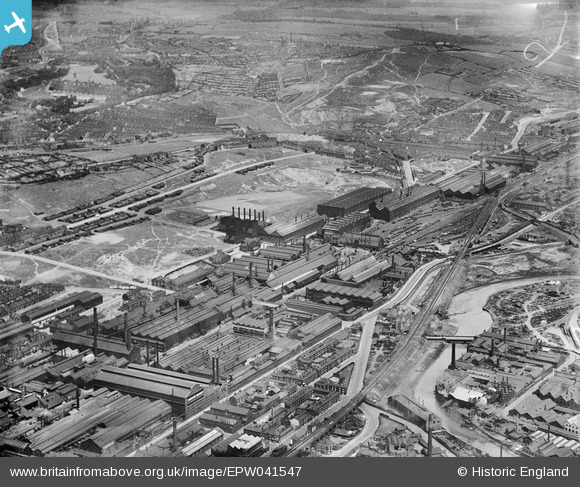
EPW041547 ENGLAND (1933). The Atlas & Norfolk Steel Works and environs, Grimesthorpe, 1933
© Copyright OpenStreetMap contributors and licensed by the OpenStreetMap Foundation. 2024. Cartography is licensed as CC BY-SA.
Nearby Images (27)
Details
| Title | [EPW041547] The Atlas & Norfolk Steel Works and environs, Grimesthorpe, 1933 |
| Reference | EPW041547 |
| Date | June-1933 |
| Link | |
| Place name | GRIMESTHORPE |
| Parish | |
| District | |
| Country | ENGLAND |
| Easting / Northing | 437083, 389288 |
| Longitude / Latitude | -1.4422230892532, 53.398853338594 |
| National Grid Reference | SK371893 |
Pins
 Class31 |
Tuesday 21st of July 2015 10:12:41 AM | |
 Class31 |
Tuesday 21st of July 2015 10:08:09 AM | |
 Class31 |
Tuesday 21st of July 2015 10:05:22 AM | |
 circloy |
Sunday 12th of October 2014 07:37:58 PM | |
2016 aerial footage in film "Wincobank - An Emerald Sanctuary" https://www.youtube.com/watch?v=nUxKc6rxINY |
 History Hunter |
Monday 19th of September 2016 09:19:18 PM |


![[EPW041547] The Atlas & Norfolk Steel Works and environs, Grimesthorpe, 1933](http://britainfromabove.org.uk/sites/all/libraries/aerofilms-images/public/100x100/EPW/041/EPW041547.jpg)
![[EAW018768] The Firth-Vickers Stainless Steels Ltd Atlas Works on Carlisle Street East, Grimesthorpe, 1948](http://britainfromabove.org.uk/sites/all/libraries/aerofilms-images/public/100x100/EAW/018/EAW018768.jpg)
![[EAW018765] The Firth-Vickers Stainless Steels Ltd Atlas Works on Carlisle Street East, Grimesthorpe, 1948. This image was marked by Aerofilms Ltd for photo editing.](http://britainfromabove.org.uk/sites/all/libraries/aerofilms-images/public/100x100/EAW/018/EAW018765.jpg)
![[EAW018767] The Firth-Vickers Stainless Steels Ltd Atlas Works on Carlisle Street East, Grimesthorpe, 1948. This image was marked by Aerofilms Ltd for photo editing.](http://britainfromabove.org.uk/sites/all/libraries/aerofilms-images/public/100x100/EAW/018/EAW018767.jpg)
![[EPW041546] The Atlas & Norfolk Steel Works and environs, Grimesthorpe, 1933](http://britainfromabove.org.uk/sites/all/libraries/aerofilms-images/public/100x100/EPW/041/EPW041546.jpg)
![[EAW018770] Recreation ground and adjacent Firth-Vickers Stainless Steels Ltd Atlas Works on Carlisle Street East, Grimesthorpe, 1948. This image was marked by Aerofilms Ltd for photo editing.](http://britainfromabove.org.uk/sites/all/libraries/aerofilms-images/public/100x100/EAW/018/EAW018770.jpg)
![[EAW009654] The Atlas and Norfolk Steel Works, Sheffield, 1947](http://britainfromabove.org.uk/sites/all/libraries/aerofilms-images/public/100x100/EAW/009/EAW009654.jpg)
![[EAW020112] Garter Street, part of the Atlas and Norfolk Steel Works and environs, Sheffield, 1948. This image has been produced from a print marked by Aerofilms Ltd for photo editing.](http://britainfromabove.org.uk/sites/all/libraries/aerofilms-images/public/100x100/EAW/020/EAW020112.jpg)
![[EAW020106] Garter Street, part of the Atlas and Norfolk Steel Works and environs, Sheffield, 1948. This image has been produced from a print marked by Aerofilms Ltd for photo editing.](http://britainfromabove.org.uk/sites/all/libraries/aerofilms-images/public/100x100/EAW/020/EAW020106.jpg)
![[EAW018769] The Firth-Vickers Stainless Steels Ltd Atlas Works on Carlisle Street East, Grimesthorpe, 1948. This image was marked by Aerofilms Ltd for photo editing.](http://britainfromabove.org.uk/sites/all/libraries/aerofilms-images/public/100x100/EAW/018/EAW018769.jpg)
![[EAW018766] Recreation ground and adjacent Firth-Vickers Stainless Steels Ltd Atlas Works on Carlisle Street East, Grimesthorpe, 1948. This image was marked by Aerofilms Ltd for photo editing.](http://britainfromabove.org.uk/sites/all/libraries/aerofilms-images/public/100x100/EAW/018/EAW018766.jpg)
![[EAW020107] Garter Street, part of the Atlas and Norfolk Steel Works and environs, Sheffield, 1948. This image has been produced from a print.](http://britainfromabove.org.uk/sites/all/libraries/aerofilms-images/public/100x100/EAW/020/EAW020107.jpg)
![[EAW018800] Recreation ground and adjacent Firth-Vickers Stainless Steels Ltd Atlas Works on Carlisle Street East, Grimesthorpe, 1948. This image has been produced from a damaged negative.](http://britainfromabove.org.uk/sites/all/libraries/aerofilms-images/public/100x100/EAW/018/EAW018800.jpg)
![[EAW020105] Petre Street, part of the Atlas and Norfolk Steel Works and environs, Sheffield, 1948. This image has been produced from a print marked by Aerofilms Ltd for photo editing.](http://britainfromabove.org.uk/sites/all/libraries/aerofilms-images/public/100x100/EAW/020/EAW020105.jpg)
![[EAW018764] Recreation ground and adjacent Firth-Vickers Stainless Steels Ltd Atlas Works on Carlisle Street East, Grimesthorpe, 1948. This image was marked by Aerofilms Ltd for photo editing.](http://britainfromabove.org.uk/sites/all/libraries/aerofilms-images/public/100x100/EAW/018/EAW018764.jpg)
![[EPW041548] The Atlas & Norfolk Steel Works and environs, Grimesthorpe, 1933](http://britainfromabove.org.uk/sites/all/libraries/aerofilms-images/public/100x100/EPW/041/EPW041548.jpg)
![[EAW009650] The Atlas and Norfolk Steel Works, Sheffield, 1947](http://britainfromabove.org.uk/sites/all/libraries/aerofilms-images/public/100x100/EAW/009/EAW009650.jpg)
![[EAW020111] Petre Street, Garter Street, part of the Atlas and Norfolk Steel Works and environs, Sheffield, 1948. This image has been produced from a print marked by Aerofilms Ltd for photo editing.](http://britainfromabove.org.uk/sites/all/libraries/aerofilms-images/public/100x100/EAW/020/EAW020111.jpg)
![[EAW020110] Petre Street, Garter Street, part of the Atlas and Norfolk Steel Works and environs, Sheffield, 1948. This image has been produced from a print marked by Aerofilms Ltd for photo editing.](http://britainfromabove.org.uk/sites/all/libraries/aerofilms-images/public/100x100/EAW/020/EAW020110.jpg)
![[EAW020109] Petre Street, Garter Street, part of the Atlas and Norfolk Steel Works and environs, Sheffield, from the east, 1948. This image has been produced from a print marked by Aerofilms Ltd for photo editing.](http://britainfromabove.org.uk/sites/all/libraries/aerofilms-images/public/100x100/EAW/020/EAW020109.jpg)
![[EAW018801] Recreation ground and adjacent Firth-Vickers Stainless Steels Ltd Atlas Works on Carlisle Street East, Grimesthorpe, 1948. This image has been produced from a print](http://britainfromabove.org.uk/sites/all/libraries/aerofilms-images/public/100x100/EAW/018/EAW018801.jpg)
![[EPW007795] The Atlas and Norfolk Steel Works, Sheffield, 1922](http://britainfromabove.org.uk/sites/all/libraries/aerofilms-images/public/100x100/EPW/007/EPW007795.jpg)
![[EPW041552] The Atlas & Norfolk Steel Works and environs, Grimesthorpe, 1933](http://britainfromabove.org.uk/sites/all/libraries/aerofilms-images/public/100x100/EPW/041/EPW041552.jpg)
![[EPW041551] The Atlas & Norfolk Steel Works, Grimesthorpe, 1933](http://britainfromabove.org.uk/sites/all/libraries/aerofilms-images/public/100x100/EPW/041/EPW041551.jpg)
![[EPW041550] The Atlas & Norfolk Steel Works, Grimesthorpe, 1933](http://britainfromabove.org.uk/sites/all/libraries/aerofilms-images/public/100x100/EPW/041/EPW041550.jpg)
![[EAW020104] Petre Street, Garter Street, part of the Atlas and Norfolk Steel Works and environs, Sheffield, 1948. This image has been produced from a print marked by Aerofilms Ltd for photo editing.](http://britainfromabove.org.uk/sites/all/libraries/aerofilms-images/public/100x100/EAW/020/EAW020104.jpg)
![[EAW020108] Petre Street, Garter Street, part of the Atlas and Norfolk Steel Works and environs, Sheffield, 1948. This image has been produced from a print marked by Aerofilms Ltd for photo editing.](http://britainfromabove.org.uk/sites/all/libraries/aerofilms-images/public/100x100/EAW/020/EAW020108.jpg)