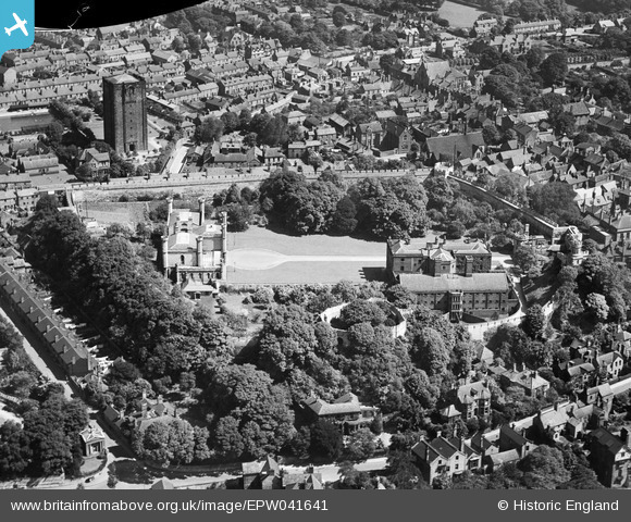
EPW041641 ENGLAND (1933). Lincoln Castle and the Westgate Water Tower, Lincoln, 1933. This image has been produced from a damaged negative.
© Copyright OpenStreetMap contributors and licensed by the OpenStreetMap Foundation. 2024. Cartography is licensed as CC BY-SA.
Nearby Images (16)
Details
| Title | [EPW041641] Lincoln Castle and the Westgate Water Tower, Lincoln, 1933. This image has been produced from a damaged negative. |
| Reference | EPW041641 |
| Date | June-1933 |
| Link | |
| Place name | LINCOLN |
| Parish | |
| District | |
| Country | ENGLAND |
| Easting / Northing | 497480, 371885 |
| Longitude / Latitude | -0.53934794481559, 53.234758496261 |
| National Grid Reference | SK975719 |
Pins
 John Herridge |
Friday 17th of September 2021 10:37:38 AM | |
 John Herridge |
Friday 17th of September 2021 10:36:48 AM | |
 John Herridge |
Friday 17th of September 2021 10:35:16 AM | |
 John Herridge |
Friday 17th of September 2021 10:34:52 AM | |
 John Herridge |
Friday 17th of September 2021 10:30:52 AM | |
 John Herridge |
Friday 17th of September 2021 10:29:45 AM | |
 John Herridge |
Friday 17th of September 2021 10:26:56 AM | |
 John Herridge |
Friday 17th of September 2021 10:26:05 AM | |
 John Herridge |
Friday 17th of September 2021 10:25:18 AM | |
 John Herridge |
Friday 17th of September 2021 10:21:42 AM | |
 John Herridge |
Friday 17th of September 2021 10:19:10 AM |


![[EPW041641] Lincoln Castle and the Westgate Water Tower, Lincoln, 1933. This image has been produced from a damaged negative.](http://britainfromabove.org.uk/sites/all/libraries/aerofilms-images/public/100x100/EPW/041/EPW041641.jpg)
![[EAW005045] Lincoln Castle and environs, Lincoln, 1947. This image has been produced from a print.](http://britainfromabove.org.uk/sites/all/libraries/aerofilms-images/public/100x100/EAW/005/EAW005045.jpg)
![[EAW015729] The city centre, Lincoln, 1948](http://britainfromabove.org.uk/sites/all/libraries/aerofilms-images/public/100x100/EAW/015/EAW015729.jpg)
![[EAW023936] Lincoln Cathedral and the site of Lincoln Castle, Lincoln, from the west, 1949. This image has been produced from a damaged negative.](http://britainfromabove.org.uk/sites/all/libraries/aerofilms-images/public/100x100/EAW/023/EAW023936.jpg)
![[EAW005041] Lincoln Castle, The Cathedral Church of the Blessed Virgin Mary and environs, Lincoln, 1947](http://britainfromabove.org.uk/sites/all/libraries/aerofilms-images/public/100x100/EAW/005/EAW005041.jpg)
![[EPW041640] Lincoln Castle, the Assize Court and the Westgate Water Tower, Lincoln, 1933](http://britainfromabove.org.uk/sites/all/libraries/aerofilms-images/public/100x100/EPW/041/EPW041640.jpg)
![[EAW005046] Lincoln Castle, The Cathedral Church of the Blessed Virgin Mary and environs, Lincoln, 1947. This image has been produced from a print.](http://britainfromabove.org.uk/sites/all/libraries/aerofilms-images/public/100x100/EAW/005/EAW005046.jpg)
![[EPW016156] The town centre, Lincoln, from the north-west, 1926](http://britainfromabove.org.uk/sites/all/libraries/aerofilms-images/public/100x100/EPW/016/EPW016156.jpg)
![[EAW003314] The Cathedral Church of the Blessed Virgin Mary, the castle and the town, Lincoln, 1946. This image has been produced from a damaged negative.](http://britainfromabove.org.uk/sites/all/libraries/aerofilms-images/public/100x100/EAW/003/EAW003314.jpg)
![[EAW015700] The city centre, Lincoln, 1948](http://britainfromabove.org.uk/sites/all/libraries/aerofilms-images/public/100x100/EAW/015/EAW015700.jpg)
![[EAW015703] The city centre, Lincoln, 1948](http://britainfromabove.org.uk/sites/all/libraries/aerofilms-images/public/100x100/EAW/015/EAW015703.jpg)
![[EPW041639] Lincoln Cathedral, Lincoln Castle and the city, Lincoln, 1933](http://britainfromabove.org.uk/sites/all/libraries/aerofilms-images/public/100x100/EPW/041/EPW041639.jpg)
![[EAW023933] Lincoln Cathedral, Lincoln, 1949. This image has been produced from a damaged negative.](http://britainfromabove.org.uk/sites/all/libraries/aerofilms-images/public/100x100/EAW/023/EAW023933.jpg)
![[EAW007366] St Mary's Cathedral and the city centre, Lincoln, from the south, 1947](http://britainfromabove.org.uk/sites/all/libraries/aerofilms-images/public/100x100/EAW/007/EAW007366.jpg)
![[EAW002781] St Mary's Cathedral and the city, Lincoln, 1946](http://britainfromabove.org.uk/sites/all/libraries/aerofilms-images/public/100x100/EAW/002/EAW002781.jpg)
![[EAW015701] The city centre, Lincoln, 1948](http://britainfromabove.org.uk/sites/all/libraries/aerofilms-images/public/100x100/EAW/015/EAW015701.jpg)