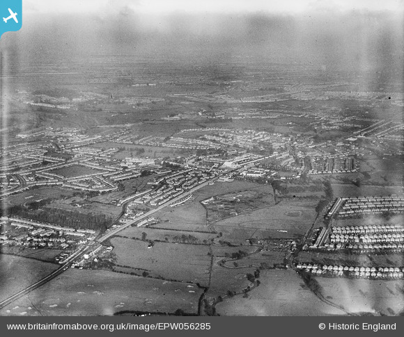
EPW056285 ENGLAND (1938). Greenford and the Ealing Coropoation Sewage Works, Greenford, from the south-east, 1938
© Copyright OpenStreetMap contributors and licensed by the OpenStreetMap Foundation. 2024. Cartography is licensed as CC BY-SA.
Details
| Title | [EPW056285] Greenford and the Ealing Coropoation Sewage Works, Greenford, from the south-east, 1938 |
| Reference | EPW056285 |
| Date | 17-January-1938 |
| Link | |
| Place name | GREENFORD |
| Parish | |
| District | |
| Country | ENGLAND |
| Easting / Northing | 514481, 181605 |
| Longitude / Latitude | -0.34974294916112, 51.521264443546 |
| National Grid Reference | TQ145816 |
Pins
 Des Elmes |
Thursday 14th of April 2016 05:07:01 PM | |
 Des Elmes |
Thursday 14th of April 2016 05:05:13 PM | |
 Des Elmes |
Thursday 14th of April 2016 05:04:05 PM | |
 Des Elmes |
Thursday 14th of April 2016 05:03:11 PM | |
 Jintygirl |
Wednesday 5th of March 2014 01:30:12 PM | |
 Jintygirl |
Wednesday 5th of March 2014 01:27:07 PM | |
 Jintygirl |
Wednesday 5th of March 2014 01:14:55 PM | |
 Jintygirl |
Wednesday 5th of March 2014 01:14:07 PM | |
 Jintygirl |
Wednesday 5th of March 2014 01:10:08 PM |


![[EPW056285] Greenford and the Ealing Coropoation Sewage Works, Greenford, from the south-east, 1938](http://britainfromabove.org.uk/sites/all/libraries/aerofilms-images/public/100x100/EPW/056/EPW056285.jpg)
![[EPW020329] New housing at Stanhope Road, Greenford, 1928](http://britainfromabove.org.uk/sites/all/libraries/aerofilms-images/public/100x100/EPW/020/EPW020329.jpg)