
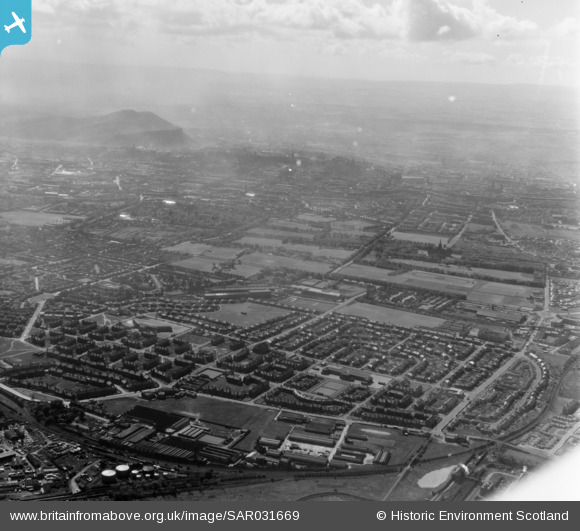
SAR031669 SCOTLAND (1958). Davidsons Mains Edinburgh, Midlothian, Scotland. An oblique aerial photograph taken facing South/East.
© Copyright OpenStreetMap contributors and licensed by the OpenStreetMap Foundation. 2025. Cartography is licensed as CC BY-SA.
Details
| Title | [SAR031669] Davidsons Mains Edinburgh, Midlothian, Scotland. An oblique aerial photograph taken facing South/East. |
| Reference | SAR031669 |
| Date | 1958 |
| Link | Canmore Collection item 1438560 |
| Place name | |
| Parish | EDINBURGH (EDINBURGH, CITY OF) |
| District | CITY OF EDINBURGH |
| Country | SCOTLAND |
| Easting / Northing | 320600, 675400 |
| Longitude / Latitude | -3.272108060035, 55.965078023238 |
| National Grid Reference | NT206754 |
Pins
 smartie148 |
Friday 3rd of December 2021 04:31:35 PM | |
admilne |
Monday 7th of November 2016 04:59:24 PM | |
Andy A |
Wednesday 18th of February 2015 11:07:02 PM | |
Andy A |
Wednesday 18th of February 2015 11:06:05 PM | |
Andy A |
Wednesday 18th of February 2015 11:05:18 PM | |
Andy A |
Wednesday 18th of February 2015 11:04:50 PM | |
Andy A |
Wednesday 18th of February 2015 11:03:59 PM | |
Andy A |
Wednesday 18th of February 2015 11:03:37 PM | |
Andy A |
Wednesday 18th of February 2015 11:03:11 PM | |
Andy A |
Wednesday 18th of February 2015 11:02:44 PM | |
Andy A |
Wednesday 18th of February 2015 11:02:23 PM |
User Comment Contributions
It's too far to the east for Davidson's Mains - the picture shows the East Pilton and Wardieburn housing areas. The roundabout on the right is Crewe Toll. |
admilne |
Tuesday 7th of October 2014 08:30:50 AM |