
Scheduled Maintenance
This website will undergo scheduled maintenance on Tuesday, September 10th, between 11:00 and 15:00, as well as on Thursday, September 12th, between 10:00 and 12:00. During this time, services may be temporarily disrupted. We apologise for any inconvenience.
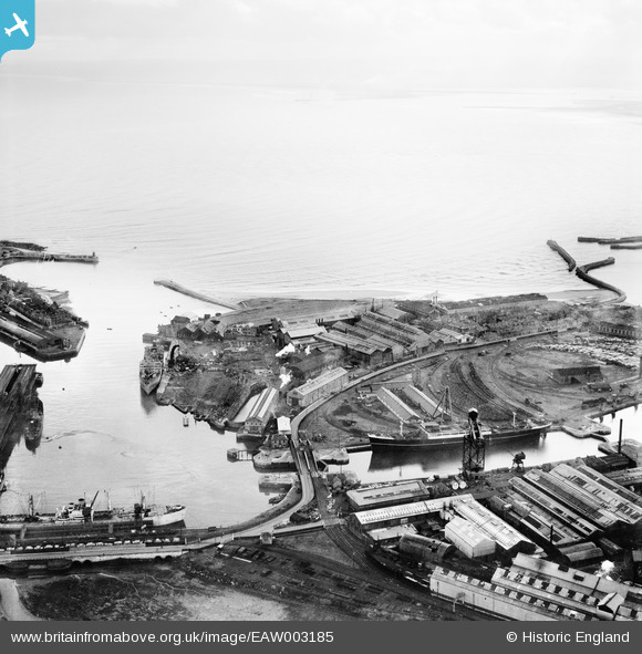
EAW003185 ENGLAND (1946). The Old Harbour, the North Basin and the Hartlepool Engine Works, Hartlepool, from the north-west, 1946
© Hawlfraint cyfranwyr OpenStreetMap a thrwyddedwyd gan yr OpenStreetMap Foundation. 2024. Trwyddedir y gartograffeg fel CC BY-SA.
Delweddau cyfagos (13)
EAW003185

EAW003186

EAW003191

EPW010608

EAW007972

EAW003192

EPW054633

EAW003203

EPW054634

EPW054635

EPW010609

EAW003190

EAW003187

Manylion
| Pennawd | [EAW003185] The Old Harbour, the North Basin and the Hartlepool Engine Works, Hartlepool, from the north-west, 1946 |
| Cyfeirnod | EAW003185 |
| Dyddiad | 23-October-1946 |
| Dolen | |
| Enw lle | HARTLEPOOL |
| Plwyf | |
| Ardal | |
| Gwlad | ENGLAND |
| Dwyreiniad / Gogleddiad | 451908, 533939 |
| Hydred / Lledred | -1.1944960887895, 54.697694707504 |
| Cyfeirnod Grid Cenedlaethol | NZ519339 |
