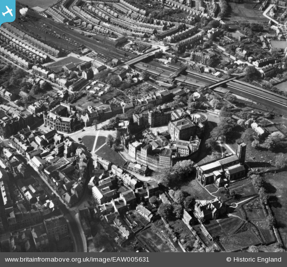
EAW005631 ENGLAND (1947). Lancaster Castle and St Mary's Church, Lancaster, 1947. This image has been produced from a print.
© Hawlfraint cyfranwyr OpenStreetMap a thrwyddedwyd gan yr OpenStreetMap Foundation. 2024. Trwyddedir y gartograffeg fel CC BY-SA.
Delweddau cyfagos (15)
Manylion
| Pennawd | [EAW005631] Lancaster Castle and St Mary's Church, Lancaster, 1947. This image has been produced from a print. |
| Cyfeirnod | EAW005631 |
| Dyddiad | 15-May-1947 |
| Dolen | |
| Enw lle | LANCASTER |
| Plwyf | |
| Ardal | |
| Gwlad | ENGLAND |
| Dwyreiniad / Gogleddiad | 347368, 461814 |
| Hydred / Lledred | -2.8039727509927, 54.049414004268 |
| Cyfeirnod Grid Cenedlaethol | SD474618 |
Pinnau
 Will |
Friday 14th of August 2015 03:23:14 AM | |
 Will |
Friday 14th of August 2015 03:21:33 AM | |
This is actually the Eastern entrance nearest the city centre and for a number of years became the only passenger entrance to the station from the mid 1960s. |
 Dirk41 |
Thursday 17th of December 2015 10:42:31 PM |
 Will |
Friday 14th of August 2015 03:18:48 AM | |
 Will |
Friday 14th of August 2015 03:16:30 AM |


![[EAW005631] Lancaster Castle and St Mary's Church, Lancaster, 1947. This image has been produced from a print.](http://britainfromabove.org.uk/sites/all/libraries/aerofilms-images/public/100x100/EAW/005/EAW005631.jpg)
![[EAW023386] Lancaster Castle, the River Lune and environs, Lancaster, from the south-west, 1949. This image has been produced from a print.](http://britainfromabove.org.uk/sites/all/libraries/aerofilms-images/public/100x100/EAW/023/EAW023386.jpg)
![[EAW005629] Lancaster Castle and St Mary's Church, Lancaster, 1947](http://britainfromabove.org.uk/sites/all/libraries/aerofilms-images/public/100x100/EAW/005/EAW005629.jpg)
![[EPW042027] Lancaster Castle and environs, Lancaster, 1933](http://britainfromabove.org.uk/sites/all/libraries/aerofilms-images/public/100x100/EPW/042/EPW042027.jpg)
![[EAW003570] Lancaster Castle, St Mary's Church and the surrounding area, Lancaster, 1947](http://britainfromabove.org.uk/sites/all/libraries/aerofilms-images/public/100x100/EAW/003/EAW003570.jpg)
![[EPW026404] Lancaster Castle, Shire Hall and St Mary's Church, Lancaster, 1929](http://britainfromabove.org.uk/sites/all/libraries/aerofilms-images/public/100x100/EPW/026/EPW026404.jpg)
![[EAW037592] Lancaster Castle and St Mary's Church, Lancaster, 1951](http://britainfromabove.org.uk/sites/all/libraries/aerofilms-images/public/100x100/EAW/037/EAW037592.jpg)
![[EPW029178] Lancaster Castle and St Mary's Church, Lancaster, 1929](http://britainfromabove.org.uk/sites/all/libraries/aerofilms-images/public/100x100/EPW/029/EPW029178.jpg)
![[EAW005630] Lancaster Castle and St Mary's Church, Lancaster, 1947. This image has been produced from a print.](http://britainfromabove.org.uk/sites/all/libraries/aerofilms-images/public/100x100/EAW/005/EAW005630.jpg)
![[EPW042028] Lancaster Castle and environs, Lancaster, 1933](http://britainfromabove.org.uk/sites/all/libraries/aerofilms-images/public/100x100/EPW/042/EPW042028.jpg)
![[EAW005632] Lancaster Castle and St Mary's Church, Lancaster, 1947. This image has been produced from a print.](http://britainfromabove.org.uk/sites/all/libraries/aerofilms-images/public/100x100/EAW/005/EAW005632.jpg)
![[EAW005633] Lancaster Castle and St Mary's Church, Lancaster, 1947. This image has been produced from a print.](http://britainfromabove.org.uk/sites/all/libraries/aerofilms-images/public/100x100/EAW/005/EAW005633.jpg)
![[EPW002092] Lancaster Castle and environs, Lancaster, 1920](http://britainfromabove.org.uk/sites/all/libraries/aerofilms-images/public/100x100/EPW/002/EPW002092.jpg)
![[EAW023385] The city centre, Lancaster, 1949](http://britainfromabove.org.uk/sites/all/libraries/aerofilms-images/public/100x100/EAW/023/EAW023385.jpg)
![[EPW002086] Lancaster Castle and environs, Lancaster, 1920](http://britainfromabove.org.uk/sites/all/libraries/aerofilms-images/public/100x100/EPW/002/EPW002086.jpg)