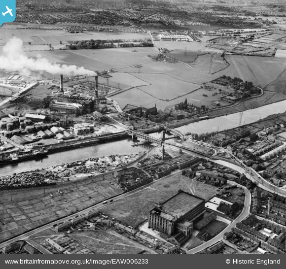
EAW006233 ENGLAND (1947). Barton Swing Aqueduct, Barton Power Station and environs, Dumplington, 1947
© Hawlfraint cyfranwyr OpenStreetMap a thrwyddedwyd gan yr OpenStreetMap Foundation. 2024. Trwyddedir y gartograffeg fel CC BY-SA.
Delweddau cyfagos (9)
Manylion
| Pennawd | [EAW006233] Barton Swing Aqueduct, Barton Power Station and environs, Dumplington, 1947 |
| Cyfeirnod | EAW006233 |
| Dyddiad | 25-May-1947 |
| Dolen | |
| Enw lle | DUMPLINGTON |
| Plwyf | |
| Ardal | |
| Gwlad | ENGLAND |
| Dwyreiniad / Gogleddiad | 376714, 397551 |
| Hydred / Lledred | -2.350868791232, 53.473921669001 |
| Cyfeirnod Grid Cenedlaethol | SJ767976 |
Pinnau
 Stretfordian |
Friday 18th of March 2022 07:45:41 PM | |
 Stretfordian |
Friday 18th of March 2022 05:35:13 PM | |
 Stretfordian |
Friday 18th of March 2022 05:32:54 PM | |
 parrot |
Wednesday 23rd of December 2020 04:24:38 PM | |
 parrot |
Wednesday 23rd of December 2020 04:24:08 PM | |
 parrot |
Wednesday 23rd of December 2020 04:23:41 PM | |
 phloberts |
Tuesday 6th of August 2019 10:27:40 PM | |
 phloberts |
Tuesday 6th of August 2019 10:26:38 PM | |
 redmist |
Sunday 6th of January 2019 10:38:57 PM | |
 Sparky |
Saturday 26th of August 2017 12:18:56 AM | |
 phloberts |
Friday 28th of August 2015 12:02:31 AM | |
 stardelta |
Wednesday 11th of June 2014 11:35:28 PM | |
 stardelta |
Wednesday 11th of June 2014 11:21:22 PM |


![[EAW006233] Barton Swing Aqueduct, Barton Power Station and environs, Dumplington, 1947](http://britainfromabove.org.uk/sites/all/libraries/aerofilms-images/public/100x100/EAW/006/EAW006233.jpg)
![[EAW006234] Barton Swing Aqueduct, Barton Upon Irwell, 1947](http://britainfromabove.org.uk/sites/all/libraries/aerofilms-images/public/100x100/EAW/006/EAW006234.jpg)
![[EAW006231] Barton Swing Aqueduct, Barton Power Station and environs, Barton Upon Irwell, 1947](http://britainfromabove.org.uk/sites/all/libraries/aerofilms-images/public/100x100/EAW/006/EAW006231.jpg)
![[EAW006230] Barton Swing Aqueduct and environs, Barton Upon Irwell, 1947](http://britainfromabove.org.uk/sites/all/libraries/aerofilms-images/public/100x100/EAW/006/EAW006230.jpg)
![[EAW006232] Barton Swing Aqueduct, Barton Power Station and environs, Trafford Park, 1947](http://britainfromabove.org.uk/sites/all/libraries/aerofilms-images/public/100x100/EAW/006/EAW006232.jpg)
![[EPW031020] The Texas Oil Co. and Manchester Ship Canal, Trafford Park, 1929](http://britainfromabove.org.uk/sites/all/libraries/aerofilms-images/public/100x100/EPW/031/EPW031020.jpg)
![[EPW027510] Barton Power Station, Trafford Park, 1929](http://britainfromabove.org.uk/sites/all/libraries/aerofilms-images/public/100x100/EPW/027/EPW027510.jpg)
![[EPW041532] Dumplington electrical substation on Redclyffe Road, Dumplington, 1933](http://britainfromabove.org.uk/sites/all/libraries/aerofilms-images/public/100x100/EPW/041/EPW041532.jpg)
![[EPW027776] Barton Power Station and environs, Dumplington, 1929. This image has been produced from a copy-negative.](http://britainfromabove.org.uk/sites/all/libraries/aerofilms-images/public/100x100/EPW/027/EPW027776.jpg)