
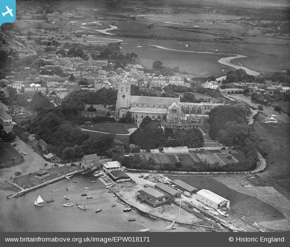
EPW018171 ENGLAND (1927). Christ Church and environs, Christchurch, 1927
© Hawlfraint cyfranwyr OpenStreetMap a thrwyddedwyd gan yr OpenStreetMap Foundation. 2024. Trwyddedir y gartograffeg fel CC BY-SA.
Delweddau cyfagos (18)
EPW018171

EPW037439

EPW013616

EAW034632

EPW013614

EAW034630

EPR000281

EPR000280

EAW049063

EAW034633

EPW018172

EPW013615

EAW034629

EAW034634

EPW037405

EAW049062

EAW034631

EPW037406

Manylion
| Pennawd | [EPW018171] Christ Church and environs, Christchurch, 1927 |
| Cyfeirnod | EPW018171 |
| Dyddiad | June-1927 |
| Dolen | |
| Enw lle | CHRISTCHURCH |
| Plwyf | |
| Ardal | |
| Gwlad | ENGLAND |
| Dwyreiniad / Gogleddiad | 416008, 92517 |
| Hydred / Lledred | -1.7731519000061, 50.731476350801 |
| Cyfeirnod Grid Cenedlaethol | SZ160925 |
Pinnau
 Voyeur |
Saturday 15th of November 2014 01:38:07 PM | |
MikeMist |
Saturday 19th of April 2014 08:33:57 PM | |
MikeMist |
Saturday 19th of April 2014 08:29:20 PM | |
MikeMist |
Saturday 19th of April 2014 08:27:24 PM | |
MikeMist |
Saturday 19th of April 2014 08:25:48 PM | |
MikeMist |
Saturday 19th of April 2014 08:22:26 PM | |
MikeMist |
Saturday 19th of April 2014 08:19:54 PM | |
MikeMist |
Saturday 19th of April 2014 08:18:54 PM | |
MikeMist |
Saturday 19th of April 2014 08:17:45 PM | |
MikeMist |
Saturday 19th of April 2014 08:16:18 PM | |
MikeMist |
Saturday 19th of April 2014 08:15:31 PM | |
MikeMist |
Saturday 19th of April 2014 08:14:53 PM |
Cyfraniadau Grŵp
Picture caption should really read something like "Christchurch Priory and environs, Christchurch, 1927" |
Noncom |
Thursday 28th of June 2012 11:09:27 AM |