
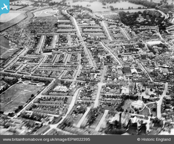
EPW022395 ENGLAND (1928). New Town, Luton, from the north-east, 1928
© Hawlfraint cyfranwyr OpenStreetMap a thrwyddedwyd gan yr OpenStreetMap Foundation. 2024. Trwyddedir y gartograffeg fel CC BY-SA.
Delweddau cyfagos (7)
EPW022395

EPW022398

EPW019219

EPW026494

EAW016040

EPW022396

EPW053993

Manylion
| Pennawd | [EPW022395] New Town, Luton, from the north-east, 1928 |
| Cyfeirnod | EPW022395 |
| Dyddiad | 9-August-1928 |
| Dolen | |
| Enw lle | LUTON |
| Plwyf | |
| Ardal | |
| Gwlad | ENGLAND |
| Dwyreiniad / Gogleddiad | 509608, 221039 |
| Hydred / Lledred | -0.4075616015495, 51.876693782828 |
| Cyfeirnod Grid Cenedlaethol | TL096210 |
Pinnau
 Dennis Jackson |
Thursday 11th of November 2021 01:17:39 PM | |
Dennis Jackson |
Thursday 11th of November 2021 01:16:44 PM | |
Dennis Jackson |
Thursday 11th of November 2021 01:15:02 PM | |
Thameslink |
Friday 4th of October 2019 12:07:29 AM | |
Thameslink |
Friday 4th of October 2019 12:05:04 AM | |
Pat |
Saturday 30th of May 2015 03:40:26 PM | |
Paul525 |
Monday 27th of May 2013 06:57:49 PM | |
Paul525 |
Monday 27th of May 2013 06:55:12 PM | |
Paul525 |
Monday 27th of May 2013 06:52:43 PM | |
Paul525 |
Monday 27th of May 2013 06:50:25 PM | |
Paul525 |
Monday 27th of May 2013 06:46:18 PM | |
Paul525 |
Monday 27th of May 2013 06:44:32 PM | |
gazza g |
Sunday 13th of January 2013 01:32:15 PM | |
gazza g |
Sunday 13th of January 2013 01:31:33 PM |
Cyfraniadau Grŵp
 St. Mary's Church, Luton, 30/06/2014 |
 Class31 |
Tuesday 1st of July 2014 02:50:07 PM |