
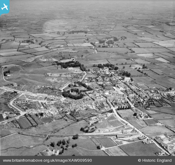
XAW009590 IRELAND (1947). General View, Tipperary, Tipperary, Ireland, 1947. Oblique aerial photograph taken facing North.
© Hawlfraint cyfranwyr OpenStreetMap a thrwyddedwyd gan yr OpenStreetMap Foundation. 2024. Trwyddedir y gartograffeg fel CC BY-SA.
Delweddau cyfagos (5)
XAW009590

XAW009589

XAW009591

XAW019155

XAW044852

Manylion
| Pennawd | [XAW009590] General View, Tipperary, Tipperary, Ireland, 1947. Oblique aerial photograph taken facing North. |
| Cyfeirnod | XAW009590 |
| Dyddiad | 15-August-1947 |
| Dolen | |
| Enw lle | TIPPERARY |
| Plwyf | IRELAND |
| Ardal | |
| Gwlad | IRELAND |
| Dwyreiniad / Gogleddiad | -18285, 304243 |
| Hydred / Lledred | -8.162702, 52.475242 |
| Cyfeirnod Grid Cenedlaethol |
Pinnau
 John Swain |
Monday 13th of October 2014 10:21:31 AM | |
John Swain |
Monday 13th of October 2014 10:20:38 AM | |
John Swain |
Monday 13th of October 2014 10:17:30 AM | |
John Swain |
Monday 13th of October 2014 10:16:19 AM | |
John Swain |
Monday 13th of October 2014 10:15:16 AM | |
John Swain |
Monday 13th of October 2014 10:12:37 AM | |
John Swain |
Monday 13th of October 2014 10:11:33 AM | |
John Swain |
Monday 13th of October 2014 10:08:55 AM | |
John Swain |
Monday 13th of October 2014 10:06:04 AM | |
John Swain |
Monday 13th of October 2014 10:05:03 AM | |
John Swain |
Monday 13th of October 2014 09:56:32 AM | |
John Swain |
Monday 13th of October 2014 09:55:47 AM | |
John Swain |
Monday 13th of October 2014 09:54:58 AM | |
John Swain |
Monday 13th of October 2014 09:54:02 AM | |
John Swain |
Monday 13th of October 2014 09:53:09 AM | |
John Swain |
Monday 13th of October 2014 09:52:26 AM | |
John Swain |
Monday 13th of October 2014 09:51:21 AM | |
John Swain |
Monday 13th of October 2014 09:50:30 AM | |
John Swain |
Monday 13th of October 2014 09:49:28 AM |
Cyfraniadau Grŵp
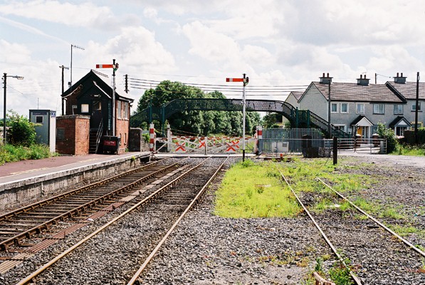 The footbridge does not link the two platforms but crosses the line to the east of Station Road level crossing, so is more probably used by non-passengers than by those wishing to take the train. A massive stone wall along the edge of the north platform is lined with flower beds. Tipperary is the highest wayside station on the line and the gradients then fall on the approach to Limerick. |
John Swain |
Monday 13th of October 2014 10:58:57 AM |
 The goods shed on the left of picture is no longer a significant feature of the station, but the footbridge and signal box remain extant. Two trains a day pass through to Waterford and Limerick Junction, from which connections may be made for Dublin and Cork. |
John Swain |
Monday 13th of October 2014 10:51:44 AM |
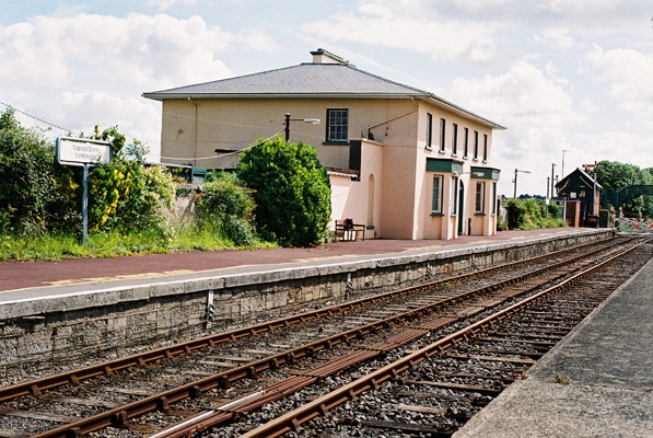 Tipperary Station was opened to traffic in 1848 when the section of the Waterford-Limerick Railway line was built between the town and Limerick. Goods traffic commenced on April 24th and passengers followed a fortnight later. Tracks were later extended to Clonmel in May 1852 and Waterford (Newrath)just over two years later, in September 1854. Station buildings consist of a large goods shed on the south side, with a two-storey, stone main building on the north platform, which has bay windows and a shallow-pitched slate roof. |
John Swain |
Monday 13th of October 2014 10:44:24 AM |
Tipperary Town (Tiobraid Arran in Irish, meaning the "Well of Arra") is one of 30 Heritage Towns in the Irish Republic, with its combination of numerous architectural styles. It is a market town and small manufacturing centre (dairy products including condensed milk)at the heart of Ireland's fertile Golden Vale, almost midway between Clonmel and Limerick. The town is an Anglo-Norman creation and there are several motte & bailey relics in the locality. The population peaked at 7,370 in 1841, since when it has declined to 5,267 in 1946, 4,500 in 1966 and 4,415 in 2006. In the busy town centre, which lies on the main routes to Limerick and Clonmel, there is a Town Hall and Clock Tower, near which is a statue of writer, poet and revolutionary, Charles J. Kickham (1826-82). |
John Swain |
Monday 13th of October 2014 10:34:12 AM |