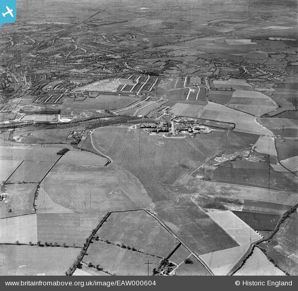
EAW000604 ENGLAND (1946). Luton Airport and the surrounding area, Luton, 1946
© Copyright OpenStreetMap contributors and licensed by the OpenStreetMap Foundation. 2024. Cartography is licensed as CC BY-SA.
Nearby Images (20)
Details
| Title | [EAW000604] Luton Airport and the surrounding area, Luton, 1946 |
| Reference | EAW000604 |
| Date | 10-May-1946 |
| Link | |
| Place name | LUTON |
| Parish | |
| District | |
| Country | ENGLAND |
| Easting / Northing | 511656, 221537 |
| Longitude / Latitude | -0.37765887897465, 51.880763614038 |
| National Grid Reference | TL117215 |
Pins
 elliechaston |
Thursday 29th of June 2023 10:34:11 AM | |
 brian |
Tuesday 7th of October 2014 08:48:30 PM | |
 brian |
Tuesday 7th of October 2014 08:44:22 PM | |
 Al |
Tuesday 7th of January 2014 01:31:31 PM | |
 SteveLV |
Saturday 16th of November 2013 09:54:29 PM | |
 SteveLV |
Saturday 16th of November 2013 09:51:25 PM | |
 SteveLV |
Saturday 16th of November 2013 09:50:14 PM | |
 SteveLV |
Saturday 16th of November 2013 09:48:59 PM | |
 SteveLV |
Saturday 16th of November 2013 09:44:56 PM | |
 SteveLV |
Saturday 16th of November 2013 09:43:20 PM | |
 SteveLV |
Saturday 16th of November 2013 09:42:38 PM | |
 SteveLV |
Saturday 16th of November 2013 09:41:25 PM | |
 SteveLV |
Saturday 16th of November 2013 09:40:23 PM | |
 SteveLV |
Saturday 16th of November 2013 09:39:22 PM | |
 SteveLV |
Saturday 16th of November 2013 09:38:47 PM | |
 SteveLV |
Saturday 16th of November 2013 09:38:11 PM |


![[EAW000604] Luton Airport and the surrounding area, Luton, 1946](http://britainfromabove.org.uk/sites/all/libraries/aerofilms-images/public/100x100/EAW/000/EAW000604.jpg)
![[EAW041143] The Percival Aircraft Ltd Works at Luton Airport, Luton, 1951](http://britainfromabove.org.uk/sites/all/libraries/aerofilms-images/public/100x100/EAW/041/EAW041143.jpg)
![[EAW024122] Aircraft outside the hangars at Luton Airport, Luton, 1949](http://britainfromabove.org.uk/sites/all/libraries/aerofilms-images/public/100x100/EAW/024/EAW024122.jpg)
![[EAW024123] Aircraft outside the hangars at Luton Airport, Luton, 1949](http://britainfromabove.org.uk/sites/all/libraries/aerofilms-images/public/100x100/EAW/024/EAW024123.jpg)
![[EAW020855] Luton Airfield and the Percival Aircraft Ltd Works, Luton, 1949](http://britainfromabove.org.uk/sites/all/libraries/aerofilms-images/public/100x100/EAW/020/EAW020855.jpg)
![[EAW024121] Aircraft outside the hangars at Luton Airport, Luton, 1949](http://britainfromabove.org.uk/sites/all/libraries/aerofilms-images/public/100x100/EAW/024/EAW024121.jpg)
![[EAW020856] Luton Airfield, Luton, 1949](http://britainfromabove.org.uk/sites/all/libraries/aerofilms-images/public/100x100/EAW/020/EAW020856.jpg)
![[EAW000606] Luton Airport and the surrounding area, Luton, 1946](http://britainfromabove.org.uk/sites/all/libraries/aerofilms-images/public/100x100/EAW/000/EAW000606.jpg)
![[EAW041144] The Percival Aircraft Ltd Works at Luton Airport, Luton, 1951](http://britainfromabove.org.uk/sites/all/libraries/aerofilms-images/public/100x100/EAW/041/EAW041144.jpg)
![[EAW041141] The Percival Aircraft Ltd Works at Luton Airport, Luton, 1951](http://britainfromabove.org.uk/sites/all/libraries/aerofilms-images/public/100x100/EAW/041/EAW041141.jpg)
![[EAW041138] The Percival Aircraft Ltd Works at Luton Airport, Luton, 1951](http://britainfromabove.org.uk/sites/all/libraries/aerofilms-images/public/100x100/EAW/041/EAW041138.jpg)
![[EAW041145] The Percival Aircraft Ltd Works at Luton Airport, Luton, 1951](http://britainfromabove.org.uk/sites/all/libraries/aerofilms-images/public/100x100/EAW/041/EAW041145.jpg)
![[EAW041142] The Percival Aircraft Ltd Works at Luton Airport, Luton, 1951](http://britainfromabove.org.uk/sites/all/libraries/aerofilms-images/public/100x100/EAW/041/EAW041142.jpg)
![[EAW041137] The Percival Aircraft Ltd Works at Luton Airport, Luton, 1951](http://britainfromabove.org.uk/sites/all/libraries/aerofilms-images/public/100x100/EAW/041/EAW041137.jpg)
![[EAW000459] The Percival Aircraft Ltd Works, Luton, 1946](http://britainfromabove.org.uk/sites/all/libraries/aerofilms-images/public/100x100/EAW/000/EAW000459.jpg)
![[EAW000463] Luton Airport and environs, Luton, 1946](http://britainfromabove.org.uk/sites/all/libraries/aerofilms-images/public/100x100/EAW/000/EAW000463.jpg)
![[EAW041139] The Percival Aircraft Ltd Works at Luton Airport, Luton, 1951](http://britainfromabove.org.uk/sites/all/libraries/aerofilms-images/public/100x100/EAW/041/EAW041139.jpg)
![[EAW000605] Luton Airport and the surrounding area, Luton, 1946](http://britainfromabove.org.uk/sites/all/libraries/aerofilms-images/public/100x100/EAW/000/EAW000605.jpg)
![[EAW020857] Luton Airfield, Luton, from the north-east, 1949](http://britainfromabove.org.uk/sites/all/libraries/aerofilms-images/public/100x100/EAW/020/EAW020857.jpg)
![[EAW041140] The Percival Aircraft Ltd Works at Luton Airport, Luton, 1951](http://britainfromabove.org.uk/sites/all/libraries/aerofilms-images/public/100x100/EAW/041/EAW041140.jpg)