Scheduled Maintenance
This website will undergo scheduled maintenance on Tuesday, September 10th, between 11:00 and 15:00, as well as on Thursday, September 12th, between 10:00 and 12:00. During this time, services may be temporarily disrupted. We apologise for any inconvenience.
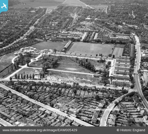
EAW005429 ENGLAND (1947). Rectory Field and prefabricated housing under construction around Rectory Field Crescent, Charlton, 1947. This image was marked by Aerofilms Ltd for photo editing.
© Copyright OpenStreetMap contributors and licensed by the OpenStreetMap Foundation. 2024. Cartography is licensed as CC BY-SA.
Nearby Images (13)
Details
| Title | [EAW005429] Rectory Field and prefabricated housing under construction around Rectory Field Crescent, Charlton, 1947. This image was marked by Aerofilms Ltd for photo editing. |
| Reference | EAW005429 |
| Date | May-1947 |
| Link | |
| Place name | CHARLTON |
| Parish | |
| District | |
| Country | ENGLAND |
| Easting / Northing | 541087, 177373 |
| Longitude / Latitude | 0.031857913100168, 51.477212260794 |
| National Grid Reference | TQ411774 |
Pins
 bushwhackers |
Thursday 22nd of February 2018 02:54:57 AM | |
 bushwhackers |
Thursday 22nd of February 2018 02:54:14 AM | |
 bushwhackers |
Thursday 22nd of February 2018 02:52:27 AM | |
 jsmithy1 |
Friday 10th of April 2015 03:57:45 PM |


![[EAW005429] Rectory Field and prefabricated housing under construction around Rectory Field Crescent, Charlton, 1947. This image was marked by Aerofilms Ltd for photo editing.](http://britainfromabove.org.uk/sites/all/libraries/aerofilms-images/public/100x100/EAW/005/EAW005429.jpg)
![[EAW005425] Prefabricated housing under construction around Rectory Field Crescent, Charlton, 1947. This image was marked by Aerofilms Ltd for photo editing.](http://britainfromabove.org.uk/sites/all/libraries/aerofilms-images/public/100x100/EAW/005/EAW005425.jpg)
![[EAW005419] Prefabricated housing under construction around Rectory Field Crescent, Rectory Field and environs, Charlton, 1947. This image was marked by Aerofilms Ltd for photo editing.](http://britainfromabove.org.uk/sites/all/libraries/aerofilms-images/public/100x100/EAW/005/EAW005419.jpg)
![[EAW005418] Prefabricated housing under construction around Rectory Field Crescent, Charlton, 1947](http://britainfromabove.org.uk/sites/all/libraries/aerofilms-images/public/100x100/EAW/005/EAW005418.jpg)
![[EAW005428] Flats at Fairlawn and prefabricated housing under construction around Rectory Field Crescent, Charlton, 1947. This image was marked by Aerofilms Ltd for photo editing.](http://britainfromabove.org.uk/sites/all/libraries/aerofilms-images/public/100x100/EAW/005/EAW005428.jpg)
![[EAW005430] Flats at Fairlawn and prefabricated housing around Rectory Field Crescent, Charlton, 1947. This image was marked by Aerofilms Ltd for photo editing.](http://britainfromabove.org.uk/sites/all/libraries/aerofilms-images/public/100x100/EAW/005/EAW005430.jpg)
![[EAW005426] Rectory Field and prefabricated housing under construction around Rectory Field Crescent, Charlton, 1947. This image was marked by Aerofilms Ltd for photo editing.](http://britainfromabove.org.uk/sites/all/libraries/aerofilms-images/public/100x100/EAW/005/EAW005426.jpg)
![[EAW005427] Flats at Fairlawn, Charlton, 1947. This image was marked by Aerofilms Ltd for photo editing.](http://britainfromabove.org.uk/sites/all/libraries/aerofilms-images/public/100x100/EAW/005/EAW005427.jpg)
![[EAW005423] Prefabricated housing under construction around Rectory Field Crescent, Rectory Field and environs, Charlton, 1947. This image was marked by Aerofilms Ltd for photo editing.](http://britainfromabove.org.uk/sites/all/libraries/aerofilms-images/public/100x100/EAW/005/EAW005423.jpg)
![[EAW005422] Prefabricated housing under construction around Rectory Field Crescent, Rectory Field and environs, Charlton, 1947. This image was marked by Aerofilms Ltd for photo editing.](http://britainfromabove.org.uk/sites/all/libraries/aerofilms-images/public/100x100/EAW/005/EAW005422.jpg)
![[EAW005420] Prefabricated housing under construction around Rectory Field Crescent, Rectory Field and environs, Charlton, 1947. This image was marked by Aerofilms Ltd for photo editing.](http://britainfromabove.org.uk/sites/all/libraries/aerofilms-images/public/100x100/EAW/005/EAW005420.jpg)
![[EAW005421] Prefabricated housing under construction around Rectory Field Crescent, Rectory Field and environs, Charlton, 1947. This image was marked by Aerofilms Ltd for photo editing.](http://britainfromabove.org.uk/sites/all/libraries/aerofilms-images/public/100x100/EAW/005/EAW005421.jpg)
![[EAW005424] Prefabricated housing under construction around Rectory Field Crescent, Rectory Field and environs, Charlton, 1947. This image was marked by Aerofilms Ltd for photo editing.](http://britainfromabove.org.uk/sites/all/libraries/aerofilms-images/public/100x100/EAW/005/EAW005424.jpg)