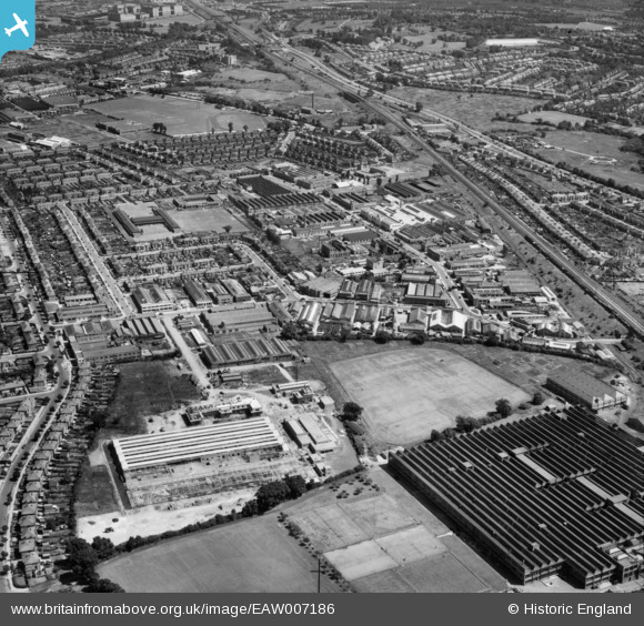
EAW007186 ENGLAND (1947). The Perivale Industrial Park and the surrounding residential area, Perivale, 1947
© Copyright OpenStreetMap contributors and licensed by the OpenStreetMap Foundation. 2024. Cartography is licensed as CC BY-SA.
Nearby Images (20)
Details
| Title | [EAW007186] The Perivale Industrial Park and the surrounding residential area, Perivale, 1947 |
| Reference | EAW007186 |
| Date | June-1947 |
| Link | |
| Place name | PERIVALE |
| Parish | |
| District | |
| Country | ENGLAND |
| Easting / Northing | 516874, 183429 |
| Longitude / Latitude | -0.31465804643597, 51.537169394266 |
| National Grid Reference | TQ169834 |
Pins
 Mark Amies |
Friday 4th of October 2024 03:21:05 PM |


![[EAW007186] The Perivale Industrial Park and the surrounding residential area, Perivale, 1947](http://britainfromabove.org.uk/sites/all/libraries/aerofilms-images/public/100x100/EAW/007/EAW007186.jpg)
![[EAW007187] The Sanderson and Sons Wallpaper Manufactory and the Perivale Industrial Park, Perivale, 1947](http://britainfromabove.org.uk/sites/all/libraries/aerofilms-images/public/100x100/EAW/007/EAW007187.jpg)
![[EAW007192] The Perivale Industrial Park, Perivale, 1947](http://britainfromabove.org.uk/sites/all/libraries/aerofilms-images/public/100x100/EAW/007/EAW007192.jpg)
![[EAW004297] The Perivale Industrial Park, Perivale, 1947](http://britainfromabove.org.uk/sites/all/libraries/aerofilms-images/public/100x100/EAW/004/EAW004297.jpg)
![[EAW007190] The Perivale Industrial Park, Perivale, 1947](http://britainfromabove.org.uk/sites/all/libraries/aerofilms-images/public/100x100/EAW/007/EAW007190.jpg)
![[EPW043713] A new housing estate off Bilton Road, Perivale, from the south-west, 1934](http://britainfromabove.org.uk/sites/all/libraries/aerofilms-images/public/100x100/EPW/043/EPW043713.jpg)
![[EPR000600] Philco Radio and Television Corporation of Great Britain Radio Factory, Perivale, 1935](http://britainfromabove.org.uk/sites/all/libraries/aerofilms-images/public/100x100/EPR/000/EPR000600.jpg)
![[EPW043716] A new housing estate off Bilton Road, Perivale, from the south, 1934](http://britainfromabove.org.uk/sites/all/libraries/aerofilms-images/public/100x100/EPW/043/EPW043716.jpg)
![[EAW004303] The Perivale Industrial Park and the surrounding residential area, Perivale, from the south-west, 1947](http://britainfromabove.org.uk/sites/all/libraries/aerofilms-images/public/100x100/EAW/004/EAW004303.jpg)
![[EAW004298] The Perivale Industrial Park and the surrounding residential area, Perivale, 1947](http://britainfromabove.org.uk/sites/all/libraries/aerofilms-images/public/100x100/EAW/004/EAW004298.jpg)
![[EPW060625] International Tin Research and Development Council Office and Laboratory on Fraser Road, Perivale, 1939](http://britainfromabove.org.uk/sites/all/libraries/aerofilms-images/public/100x100/EPW/060/EPW060625.jpg)
![[EPW060624] International Tin Research and Development Council Office and Laboratory on Fraser Road, Perivale, 1939](http://britainfromabove.org.uk/sites/all/libraries/aerofilms-images/public/100x100/EPW/060/EPW060624.jpg)
![[EAW004302] The Perivale Industrial Park and the surrounding residential area, Perivale, 1947](http://britainfromabove.org.uk/sites/all/libraries/aerofilms-images/public/100x100/EAW/004/EAW004302.jpg)
![[EPW060622] International Tin Research and Development Council Office and Laboratory on Fraser Road, Perivale, 1939](http://britainfromabove.org.uk/sites/all/libraries/aerofilms-images/public/100x100/EPW/060/EPW060622.jpg)
![[EPW060621] International Tin Research and Development Council Office and Laboratory on Fraser Road, Perivale, 1939](http://britainfromabove.org.uk/sites/all/libraries/aerofilms-images/public/100x100/EPW/060/EPW060621.jpg)
![[EPW060619] International Tin Research and Development Council Office and Laboratory on Fraser Road, Perivale, 1939](http://britainfromabove.org.uk/sites/all/libraries/aerofilms-images/public/100x100/EPW/060/EPW060619.jpg)
![[EPW060620] International Tin Research and Development Council Office and Laboratory on Fraser Road, Perivale, 1939](http://britainfromabove.org.uk/sites/all/libraries/aerofilms-images/public/100x100/EPW/060/EPW060620.jpg)
![[EPW042711] A new housing estate, Perivale, 1933](http://britainfromabove.org.uk/sites/all/libraries/aerofilms-images/public/100x100/EPW/042/EPW042711.jpg)
![[EPW060623] International Tin Research and Development Council Office and Laboratory on Fraser Road, Perivale, 1939](http://britainfromabove.org.uk/sites/all/libraries/aerofilms-images/public/100x100/EPW/060/EPW060623.jpg)
![[EPR000614] The Central Joinery Co Ltd Works, Perivale, 1935. This image was marked by Aero Pictorial Ltd for photo editing.](http://britainfromabove.org.uk/sites/all/libraries/aerofilms-images/public/100x100/EPR/000/EPR000614.jpg)