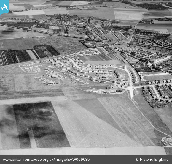
EAW009035 ENGLAND (1947). The residential area at Newington (surrounding Melbourne Avenue) under construction and the surrounding area, Ramsgate, 1947
© Copyright OpenStreetMap contributors and licensed by the OpenStreetMap Foundation. 2024. Cartography is licensed as CC BY-SA.
Nearby Images (10)
Details
| Title | [EAW009035] The residential area at Newington (surrounding Melbourne Avenue) under construction and the surrounding area, Ramsgate, 1947 |
| Reference | EAW009035 |
| Date | 12-August-1947 |
| Link | |
| Place name | RAMSGATE |
| Parish | RAMSGATE |
| District | |
| Country | ENGLAND |
| Easting / Northing | 636483, 166287 |
| Longitude / Latitude | 1.3962322473488, 51.345877376878 |
| National Grid Reference | TR365663 |
Pins
Be the first to add a comment to this image!


![[EAW009035] The residential area at Newington (surrounding Melbourne Avenue) under construction and the surrounding area, Ramsgate, 1947](http://britainfromabove.org.uk/sites/all/libraries/aerofilms-images/public/100x100/EAW/009/EAW009035.jpg)
![[EAW009041] The residential area at Newington (surrounding Melbourne Avenue) under construction and the surrounding area, Ramsgate, 1947](http://britainfromabove.org.uk/sites/all/libraries/aerofilms-images/public/100x100/EAW/009/EAW009041.jpg)
![[EAW009036] The residential area at Newington (surrounding Melbourne Avenue) under construction, Ramsgate, 1947](http://britainfromabove.org.uk/sites/all/libraries/aerofilms-images/public/100x100/EAW/009/EAW009036.jpg)
![[EAW009037] The residential area at Newington (surrounding Melbourne Avenue) under construction, Ramsgate, 1947](http://britainfromabove.org.uk/sites/all/libraries/aerofilms-images/public/100x100/EAW/009/EAW009037.jpg)
![[EAW009042] The residential area at Newington (surrounding Melbourne Avenue) under construction, Ramsgate, 1947](http://britainfromabove.org.uk/sites/all/libraries/aerofilms-images/public/100x100/EAW/009/EAW009042.jpg)
![[EAW009032] The residential area at Newington (surrounding Melbourne Avenue) under construction, Ramsgate, 1947](http://britainfromabove.org.uk/sites/all/libraries/aerofilms-images/public/100x100/EAW/009/EAW009032.jpg)
![[EAW009034] The residential area at Newington (surrounding Melbourne Avenue) under construction, Ramsgate, 1947](http://britainfromabove.org.uk/sites/all/libraries/aerofilms-images/public/100x100/EAW/009/EAW009034.jpg)
![[EAW009038] The residential area at Newington (surrounding Melbourne Avenue) under construction, Ramsgate, 1947](http://britainfromabove.org.uk/sites/all/libraries/aerofilms-images/public/100x100/EAW/009/EAW009038.jpg)
![[EAW009043] The residential area at Newington (surrounding Melbourne Avenue) under construction, Ramsgate, 1947](http://britainfromabove.org.uk/sites/all/libraries/aerofilms-images/public/100x100/EAW/009/EAW009043.jpg)
![[EAW009033] The residential area at Newington (surrounding Melbourne Avenue) under construction, Ramsgate, 1947](http://britainfromabove.org.uk/sites/all/libraries/aerofilms-images/public/100x100/EAW/009/EAW009033.jpg)