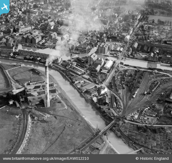
EAW012210 ENGLAND (1947). Gloucester Docks and the surrounding industrial area, Gloucester, 1947
© Copyright OpenStreetMap contributors and licensed by the OpenStreetMap Foundation. 2024. Cartography is licensed as CC BY-SA.
Nearby Images (25)
Details
| Title | [EAW012210] Gloucester Docks and the surrounding industrial area, Gloucester, 1947 |
| Reference | EAW012210 |
| Date | 13-November-1947 |
| Link | |
| Place name | GLOUCESTER |
| Parish | |
| District | |
| Country | ENGLAND |
| Easting / Northing | 382516, 218246 |
| Longitude / Latitude | -2.253926211275, 51.862081231927 |
| National Grid Reference | SO825182 |
Pins
 Sparky |
Saturday 30th of September 2017 09:36:40 PM | |
 MB |
Sunday 24th of November 2013 03:42:37 PM | |
 MB |
Sunday 24th of November 2013 03:27:55 PM | |
 MB |
Sunday 24th of November 2013 03:27:00 PM | |
 MB |
Sunday 24th of November 2013 03:25:07 PM |


![[EAW012210] Gloucester Docks and the surrounding industrial area, Gloucester, 1947](http://britainfromabove.org.uk/sites/all/libraries/aerofilms-images/public/100x100/EAW/012/EAW012210.jpg)
![[EAW021185] Castle Meads Power Station and the docks, Gloucester, 1949. This image has been produced from a print.](http://britainfromabove.org.uk/sites/all/libraries/aerofilms-images/public/100x100/EAW/021/EAW021185.jpg)
![[EAW021182] Castle Meads Power Station and environs, Gloucester, from the east, 1949. This image has been produced from a print.](http://britainfromabove.org.uk/sites/all/libraries/aerofilms-images/public/100x100/EAW/021/EAW021182.jpg)
![[EAW018728] The site of Llanthony Secunda Priory, Castle Meads and environs, Gloucester, 1948. This image has been produced from a print.](http://britainfromabove.org.uk/sites/all/libraries/aerofilms-images/public/100x100/EAW/018/EAW018728.jpg)
![[EAW021181] Castle Meads Power Station and the River Severn East Channel, Gloucester, 1949. This image has been produced from a print marked by Aerofilms Ltd for photo editing.](http://britainfromabove.org.uk/sites/all/libraries/aerofilms-images/public/100x100/EAW/021/EAW021181.jpg)
![[EAW021184] Castle Meads Power Station and environs, Gloucester, from the south, 1949. This image has been produced from a print.](http://britainfromabove.org.uk/sites/all/libraries/aerofilms-images/public/100x100/EAW/021/EAW021184.jpg)
![[EAW012202] Gloucester Docks, Gloucester, 1947](http://britainfromabove.org.uk/sites/all/libraries/aerofilms-images/public/100x100/EAW/012/EAW012202.jpg)
![[EPW037837] Railway sidings next to Llanthony Priory and surroundings, Gloucester, 1932](http://britainfromabove.org.uk/sites/all/libraries/aerofilms-images/public/100x100/EPW/037/EPW037837.jpg)
![[EAW012200] Gloucester Docks, Gloucester, 1947](http://britainfromabove.org.uk/sites/all/libraries/aerofilms-images/public/100x100/EAW/012/EAW012200.jpg)
![[EPW037834] The docks, Gloucester, 1932](http://britainfromabove.org.uk/sites/all/libraries/aerofilms-images/public/100x100/EPW/037/EPW037834.jpg)
![[EAW012209] Gloucester Docks and the surrounding area, Gloucester, 1947](http://britainfromabove.org.uk/sites/all/libraries/aerofilms-images/public/100x100/EAW/012/EAW012209.jpg)
![[EPW037750] The docks and the city, Gloucester, 1932](http://britainfromabove.org.uk/sites/all/libraries/aerofilms-images/public/100x100/EPW/037/EPW037750.jpg)
![[EPW037749] The docks, Gloucester, 1932](http://britainfromabove.org.uk/sites/all/libraries/aerofilms-images/public/100x100/EPW/037/EPW037749.jpg)
![[EAW012197] Gloucester Docks, Gloucester, 1947](http://britainfromabove.org.uk/sites/all/libraries/aerofilms-images/public/100x100/EAW/012/EAW012197.jpg)
![[EAW012204] Gloucester Docks and the surrounding warehouses, Gloucester, 1947](http://britainfromabove.org.uk/sites/all/libraries/aerofilms-images/public/100x100/EAW/012/EAW012204.jpg)
![[EAW021183] Castle Meads Power Station and the city, Gloucester, 1949. This image has been produced from a print.](http://britainfromabove.org.uk/sites/all/libraries/aerofilms-images/public/100x100/EAW/021/EAW021183.jpg)
![[EPW037751] The docks and the city, Gloucester, 1932](http://britainfromabove.org.uk/sites/all/libraries/aerofilms-images/public/100x100/EPW/037/EPW037751.jpg)
![[EAW012211] Gloucester Docks, the remains of Llanthony Secunda Priory and the surrounding industrial area, Gloucester, 1947](http://britainfromabove.org.uk/sites/all/libraries/aerofilms-images/public/100x100/EAW/012/EAW012211.jpg)
![[EAW012207] Gloucester Docks and the surrounding warehouses, Gloucester, 1947](http://britainfromabove.org.uk/sites/all/libraries/aerofilms-images/public/100x100/EAW/012/EAW012207.jpg)
![[EPW024161] The Docks, Gloucester, 1928](http://britainfromabove.org.uk/sites/all/libraries/aerofilms-images/public/100x100/EPW/024/EPW024161.jpg)
![[EAW021187] Castle Meads Power Station and environs, Gloucester, 1949. This image has been produced from a print.](http://britainfromabove.org.uk/sites/all/libraries/aerofilms-images/public/100x100/EAW/021/EAW021187.jpg)
![[EPW048244] The Docks and the city, Gloucester, 1935. This image has been produced from a copy-negative.](http://britainfromabove.org.uk/sites/all/libraries/aerofilms-images/public/100x100/EPW/048/EPW048244.jpg)
![[EPW038346] Stephens Glevum Incubator Works and grounds of Llanthony Secunda Priory, Gloucester, 1932](http://britainfromabove.org.uk/sites/all/libraries/aerofilms-images/public/100x100/EPW/038/EPW038346.jpg)
![[EPW038343] Stephens Glevum Incubator Works, Gloucester, 1932](http://britainfromabove.org.uk/sites/all/libraries/aerofilms-images/public/100x100/EPW/038/EPW038343.jpg)
![[EPW024154] Gloucester prison and the docks, Gloucester, 1928](http://britainfromabove.org.uk/sites/all/libraries/aerofilms-images/public/100x100/EPW/024/EPW024154.jpg)