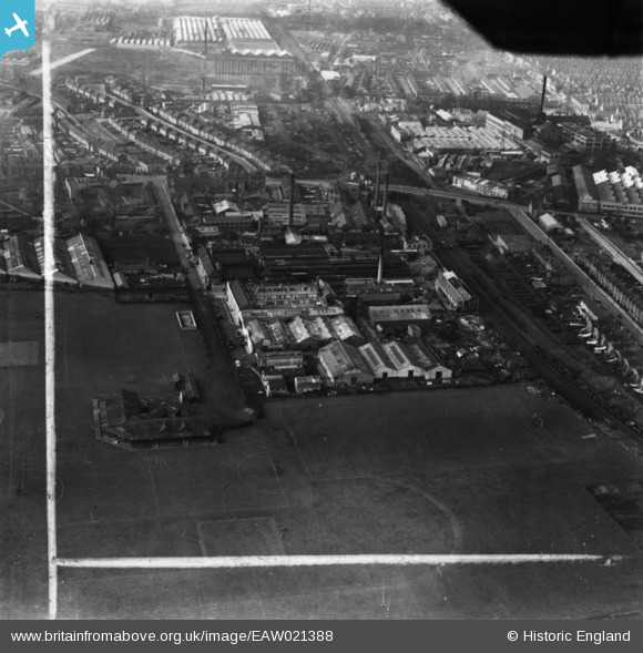
EAW021388 ENGLAND (1949). The James Ferguson and Sons Ltd Lea Park Works and environs, Collier's Wood, 1949. This image has been produced from a print marked by Aerofilms Ltd for photo editing.
© Copyright OpenStreetMap contributors and licensed by the OpenStreetMap Foundation. 2024. Cartography is licensed as CC BY-SA.
Nearby Images (27)
Details
| Title | [EAW021388] The James Ferguson and Sons Ltd Lea Park Works and environs, Collier's Wood, 1949. This image has been produced from a print marked by Aerofilms Ltd for photo editing. |
| Reference | EAW021388 |
| Date | 15-March-1949 |
| Link | |
| Place name | COLLIER'S WOOD |
| Parish | |
| District | |
| Country | ENGLAND |
| Easting / Northing | 527035, 169942 |
| Longitude / Latitude | -0.17306242990903, 51.413753241181 |
| National Grid Reference | TQ270699 |
Pins
Be the first to add a comment to this image!


![[EAW021388] The James Ferguson and Sons Ltd Lea Park Works and environs, Collier's Wood, 1949. This image has been produced from a print marked by Aerofilms Ltd for photo editing.](http://britainfromabove.org.uk/sites/all/libraries/aerofilms-images/public/100x100/EAW/021/EAW021388.jpg)
![[EAW021386] The James Ferguson and Sons Ltd Lea Park Works and environs, Collier's Wood, 1949. This image has been produced from a print marked by Aerofilms Ltd for photo editing.](http://britainfromabove.org.uk/sites/all/libraries/aerofilms-images/public/100x100/EAW/021/EAW021386.jpg)
![[EAW021389] The James Ferguson and Sons Ltd Lea Park Works, Collier's Wood, 1949. This image has been produced from a print marked by Aerofilms Ltd for photo editing.](http://britainfromabove.org.uk/sites/all/libraries/aerofilms-images/public/100x100/EAW/021/EAW021389.jpg)
![[EAW021385] The James Ferguson and Sons Ltd Lea Park Works and environs, Collier's Wood, 1949. This image has been produced from a print marked by Aerofilms Ltd for photo editing.](http://britainfromabove.org.uk/sites/all/libraries/aerofilms-images/public/100x100/EAW/021/EAW021385.jpg)
![[EAW021387] The James Ferguson and Sons Ltd Lea Park Works and environs, Collier's Wood, 1949. This image has been produced from a print marked by Aerofilms Ltd for photo editing.](http://britainfromabove.org.uk/sites/all/libraries/aerofilms-images/public/100x100/EAW/021/EAW021387.jpg)
![[EAW021391] The James Ferguson and Sons Ltd Lea Park Works and environs, Collier's Wood, 1949. This image has been produced from a print marked by Aerofilms Ltd for photo editing.](http://britainfromabove.org.uk/sites/all/libraries/aerofilms-images/public/100x100/EAW/021/EAW021391.jpg)
![[EAW021529] Fry's Diecasting Ltd Works and other factories on Prince George's Road, Merton, 1949. This image was marked by Aerofilms Ltd for photo editing.](http://britainfromabove.org.uk/sites/all/libraries/aerofilms-images/public/100x100/EAW/021/EAW021529.jpg)
![[EAW021524] Fry's Diecasting Ltd Works and other factories on Prince George's Road, Merton, 1949. This image has been produced from a damaged negative.](http://britainfromabove.org.uk/sites/all/libraries/aerofilms-images/public/100x100/EAW/021/EAW021524.jpg)
![[EAW021390] The James Ferguson and Sons Ltd Lea Park Works and environs, Collier's Wood, 1949. This image has been produced from a print marked by Aerofilms Ltd for photo editing.](http://britainfromabove.org.uk/sites/all/libraries/aerofilms-images/public/100x100/EAW/021/EAW021390.jpg)
![[EAW021527] Fry's Diecasting Ltd Works and other factories on Prince George's Road, Merton, 1949. This image has been produced from a damaged negative.](http://britainfromabove.org.uk/sites/all/libraries/aerofilms-images/public/100x100/EAW/021/EAW021527.jpg)
![[EAW021384] The James Ferguson and Sons Ltd Lea Park Works and environs, Collier's Wood, 1949. This image has been produced from a print marked by Aerofilms Ltd for photo editing.](http://britainfromabove.org.uk/sites/all/libraries/aerofilms-images/public/100x100/EAW/021/EAW021384.jpg)
![[EAW021523] Fry's Diecasting Ltd Works and other factories on Prince George's Road, Merton, from the south-east, 1949. This image has been produced from a damaged negative.](http://britainfromabove.org.uk/sites/all/libraries/aerofilms-images/public/100x100/EAW/021/EAW021523.jpg)
![[EAW021528] Fry's Diecasting Ltd Works and other factories on Prince George's Road, Merton, 1949. This image has been produced from a damaged negative.](http://britainfromabove.org.uk/sites/all/libraries/aerofilms-images/public/100x100/EAW/021/EAW021528.jpg)
![[EAW005282] The Eyre Smelting Co Ltd Tandem Smelting Works, Christchurch Road, Prince Georges Road and environs, Collier's Wood, 1947](http://britainfromabove.org.uk/sites/all/libraries/aerofilms-images/public/100x100/EAW/005/EAW005282.jpg)
![[EAW005288] The Eyre Smelting Co Ltd Tandem Smelting Works, Christchurch Road and environs, Collier's Wood, 1947. This image was marked by Aerofilms Ltd for photo editing.](http://britainfromabove.org.uk/sites/all/libraries/aerofilms-images/public/100x100/EAW/005/EAW005288.jpg)
![[EAW005280] The Eyre Smelting Co Ltd Tandem Smelting Works, Christchurch Road, Prince Georges Road and environs, Collier's Wood, 1947. This image was marked by Aerofilms Ltd for photo editing.](http://britainfromabove.org.uk/sites/all/libraries/aerofilms-images/public/100x100/EAW/005/EAW005280.jpg)
![[EAW021530] Fry's Diecasting Ltd Works and other factories on Prince George's Road, Merton, 1949. This image was marked by Aerofilms Ltd for photo editing.](http://britainfromabove.org.uk/sites/all/libraries/aerofilms-images/public/100x100/EAW/021/EAW021530.jpg)
![[EAW021526] Fry's Diecasting Ltd Works and other factories on Prince George's Road, Merton, from the south, 1949. This image has been produced from a damaged negative.](http://britainfromabove.org.uk/sites/all/libraries/aerofilms-images/public/100x100/EAW/021/EAW021526.jpg)
![[EAW021525] Fry's Diecasting Ltd Works and other factories on Prince George's Road, Merton, 1949. This image has been produced from a damaged negative.](http://britainfromabove.org.uk/sites/all/libraries/aerofilms-images/public/100x100/EAW/021/EAW021525.jpg)
![[EAW005287] The Eyre Smelting Co Ltd Tandem Smelting Works, Christchurch Road and environs, Collier's Wood, 1947. This image was marked by Aerofilms Ltd for photo editing.](http://britainfromabove.org.uk/sites/all/libraries/aerofilms-images/public/100x100/EAW/005/EAW005287.jpg)
![[EAW005284] The Eyre Smelting Co Ltd Tandem Smelting Works, Collier's Wood, 1947](http://britainfromabove.org.uk/sites/all/libraries/aerofilms-images/public/100x100/EAW/005/EAW005284.jpg)
![[EPW010770] The Eyre Smelting Co Ltd Tandem Smelting Works, Collier's Wood, 1924. This image has been produced from a print.](http://britainfromabove.org.uk/sites/all/libraries/aerofilms-images/public/100x100/EPW/010/EPW010770.jpg)
![[EAW005286] The Eyre Smelting Co Ltd Tandem Smelting Works, Christchurch Road and environs, Collier's Wood, 1947](http://britainfromabove.org.uk/sites/all/libraries/aerofilms-images/public/100x100/EAW/005/EAW005286.jpg)
![[EAW005283] The Eyre Smelting Co Ltd Tandem Smelting Works, Christchurch Road, Prince Georges Road and environs, Collier's Wood, 1947. This image was marked by Aerofilms Ltd for photo editing.](http://britainfromabove.org.uk/sites/all/libraries/aerofilms-images/public/100x100/EAW/005/EAW005283.jpg)
![[EAW005281] The Eyre Smelting Co Ltd Tandem Smelting Works, Christchurch Road, Prince Georges Road and environs, Collier's Wood, 1947](http://britainfromabove.org.uk/sites/all/libraries/aerofilms-images/public/100x100/EAW/005/EAW005281.jpg)
![[EAW004934] The Eyre Smelting Co Ltd Tandem Smelting Works, Collier's Wood, 1947. This image has been produced from a copy-negative.](http://britainfromabove.org.uk/sites/all/libraries/aerofilms-images/public/100x100/EAW/004/EAW004934.jpg)
![[EAW005285] The Eyre Smelting Co Ltd Tandem Smelting Works and environs, Collier's Wood, 1947](http://britainfromabove.org.uk/sites/all/libraries/aerofilms-images/public/100x100/EAW/005/EAW005285.jpg)