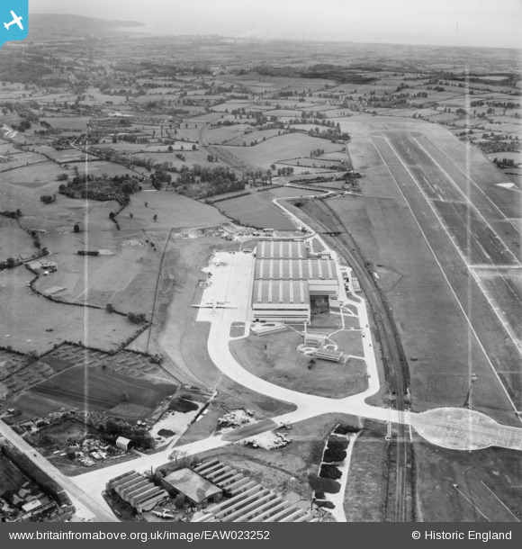
EAW023252 ENGLAND (1949). The Aircraft Assembly Hall (Brabazon Hangar) and runway at Bristol Filton Airport, Filton, from the east, 1949. This image was marked by Aerofilms Ltd for photo editing.
© Copyright OpenStreetMap contributors and licensed by the OpenStreetMap Foundation. 2024. Cartography is licensed as CC BY-SA.
Nearby Images (36)
Details
| Title | [EAW023252] The Aircraft Assembly Hall (Brabazon Hangar) and runway at Bristol Filton Airport, Filton, from the east, 1949. This image was marked by Aerofilms Ltd for photo editing. |
| Reference | EAW023252 |
| Date | 23-May-1949 |
| Link | |
| Place name | FILTON |
| Parish | FILTON |
| District | |
| Country | ENGLAND |
| Easting / Northing | 359877, 179863 |
| Longitude / Latitude | -2.5782925424861, 51.515781697531 |
| National Grid Reference | ST599799 |
Pins
 cptpies |
Thursday 9th of January 2014 12:42:54 PM |


![[EAW023252] The Aircraft Assembly Hall (Brabazon Hangar) and runway at Bristol Filton Airport, Filton, from the east, 1949. This image was marked by Aerofilms Ltd for photo editing.](http://britainfromabove.org.uk/sites/all/libraries/aerofilms-images/public/100x100/EAW/023/EAW023252.jpg)
![[EAW026958] The Aircraft Assembly Hall (Brabazon Hangar) at Bristol Filton Airport, Bristol, from the east, 1949. This image has been produced from a damaged negative.](http://britainfromabove.org.uk/sites/all/libraries/aerofilms-images/public/100x100/EAW/026/EAW026958.jpg)
![[EAW027401] The Aircraft Assembly Hall (Brabazon Hangar) at Bristol Filton Airport, Bristol, from the east, 1949. This image has been produced from a damaged negative.](http://britainfromabove.org.uk/sites/all/libraries/aerofilms-images/public/100x100/EAW/027/EAW027401.jpg)
![[EAW027400] Part of the Aircraft Assembly Hall (Brabazon Hangar) at Bristol Filton Airport, Bristol, 1949](http://britainfromabove.org.uk/sites/all/libraries/aerofilms-images/public/100x100/EAW/027/EAW027400.jpg)
![[EAW019147] The Aircraft Assembly Hall (Brabazon Hangar) at Bristol Filton Airport, Bristol, from the east, 1948. This image was marked by Aerofilms Ltd for photo editing.](http://britainfromabove.org.uk/sites/all/libraries/aerofilms-images/public/100x100/EAW/019/EAW019147.jpg)
![[EAW023244] The Aircraft Assembly Hall (Brabazon Hangar) and runway at Bristol Filton Airport, Filton, from the south-east, 1949. This image has been produced from a print marked by Aerofilms Ltd for photo editing.](http://britainfromabove.org.uk/sites/all/libraries/aerofilms-images/public/100x100/EAW/023/EAW023244.jpg)
![[EAW027402] The Aircraft Assembly Hall (Brabazon Hangar) at Bristol Filton Airport, Bristol, from the south-east, 1949. This image has been produced from a print marked by Aerofilms Ltd for photo editing.](http://britainfromabove.org.uk/sites/all/libraries/aerofilms-images/public/100x100/EAW/027/EAW027402.jpg)
![[EAW013032] The Aircraft Assembly Hall (Brabazon Hangar) under construction at Bristol Filton Airport, Bristol, 1948. This image has been produced from a print.](http://britainfromabove.org.uk/sites/all/libraries/aerofilms-images/public/100x100/EAW/013/EAW013032.jpg)
![[EAW020942] The Aircraft Assembly Hall (Brabazon Hangar) at Bristol Filton Airport, Bristol, from the south-east, 1949. This image was marked by Aerofilms Ltd for photo editing.](http://britainfromabove.org.uk/sites/all/libraries/aerofilms-images/public/100x100/EAW/020/EAW020942.jpg)
![[EAW016124] The Aircraft Assembly Hall (Brabazon Hangar) nearing completion at Bristol Filton Airport, Bristol, 1948. This image has been produced from a damaged negative.](http://britainfromabove.org.uk/sites/all/libraries/aerofilms-images/public/100x100/EAW/016/EAW016124.jpg)
![[EAW027405] Part of the Aircraft Assembly Hall (Brabazon Hangar) at Bristol Filton Airport, Bristol, 1949. This image has been produced from a print marked by Aerofilms Ltd for photo editing.](http://britainfromabove.org.uk/sites/all/libraries/aerofilms-images/public/100x100/EAW/027/EAW027405.jpg)
![[EAW024889] The Aircraft Assembly Hall (Brabazon Hangar) at Bristol Filton Airport, Bristol, from the south-east, 1949](http://britainfromabove.org.uk/sites/all/libraries/aerofilms-images/public/100x100/EAW/024/EAW024889.jpg)
![[EAW004162] The Aircraft Assembly Hall (Brabazon Hangar) under construction at Bristol Filton Airport, Bristol, 1947](http://britainfromabove.org.uk/sites/all/libraries/aerofilms-images/public/100x100/EAW/004/EAW004162.jpg)
![[EAW020928] The Aircraft Assembly Hall (Brabazon Hangar) at Bristol Filton Airport, Bristol, 1949](http://britainfromabove.org.uk/sites/all/libraries/aerofilms-images/public/100x100/EAW/020/EAW020928.jpg)
![[EAW024895] The Aircraft Assembly Hall (Brabazon Hangar) at Bristol Filton Airport, Bristol, 1949](http://britainfromabove.org.uk/sites/all/libraries/aerofilms-images/public/100x100/EAW/024/EAW024895.jpg)
![[EAW024896] The Aircraft Assembly Hall (Brabazon Hangar) at Bristol Filton Airport, Bristol, 1949. This image was marked by Aerofilms Ltd for photo editing.](http://britainfromabove.org.uk/sites/all/libraries/aerofilms-images/public/100x100/EAW/024/EAW024896.jpg)
![[EAW026955] The Aircraft Assembly Hall (Brabazon Hangar) at Bristol Filton Airport, Bristol, from the south, 1949. This image has been produced from a print.](http://britainfromabove.org.uk/sites/all/libraries/aerofilms-images/public/100x100/EAW/026/EAW026955.jpg)
![[EAW017483] The Aircraft Assembly Hall (Brabazon Hangar) nearing completion at Bristol Filton Airport, Bristol, 1948](http://britainfromabove.org.uk/sites/all/libraries/aerofilms-images/public/100x100/EAW/017/EAW017483.jpg)
![[EAW027406] Part of the Aircraft Assembly Hall (Brabazon Hangar) at Bristol Filton Airport, Bristol, 1949. This image has been produced from a print marked by Aerofilms Ltd for photo editing.](http://britainfromabove.org.uk/sites/all/libraries/aerofilms-images/public/100x100/EAW/027/EAW027406.jpg)
![[EAW027403] The Aircraft Assembly Hall (Brabazon Hangar) at Bristol Filton Airport, Bristol, 1949. This image has been produced from a print marked by Aerofilms Ltd for photo editing.](http://britainfromabove.org.uk/sites/all/libraries/aerofilms-images/public/100x100/EAW/027/EAW027403.jpg)
![[EAW013024] The Aircraft Assembly Hall (Brabazon Hangar) under construction at Bristol Filton Airport, Bristol, from the south-east, 1948. This image has been produced from a print.](http://britainfromabove.org.uk/sites/all/libraries/aerofilms-images/public/100x100/EAW/013/EAW013024.jpg)
![[EAW013936] The Aircraft Assembly Hangar (Brabazon Hangar) under construction at Bristol Filton Airport, Bristol, 1948. This image has been produced from a print.](http://britainfromabove.org.uk/sites/all/libraries/aerofilms-images/public/100x100/EAW/013/EAW013936.jpg)
![[EAW013020] The Aircraft Assembly Hall (Brabazon Hangar) under construction at Bristol Filton Airport, Bristol, 1948. This image has been produced from a damaged negative.](http://britainfromabove.org.uk/sites/all/libraries/aerofilms-images/public/100x100/EAW/013/EAW013020.jpg)
![[EAW020587] The Aircraft Assembly Hall (Brabazon Hangar) at Bristol Filton Airport, Bristol, from the south-east, 1948. This image was marked by Aerofilms Ltd for photo editing.](http://britainfromabove.org.uk/sites/all/libraries/aerofilms-images/public/100x100/EAW/020/EAW020587.jpg)
![[EAW007036] The Aircraft Assembly Hall (Brabazon Hangar) under construction at Bristol Filton Airport, Bristol, 1947](http://britainfromabove.org.uk/sites/all/libraries/aerofilms-images/public/100x100/EAW/007/EAW007036.jpg)
![[EAW020929] The Aircraft Assembly Hall (Brabazon Hangar) at Bristol Filton Airport, Bristol, 1949](http://britainfromabove.org.uk/sites/all/libraries/aerofilms-images/public/100x100/EAW/020/EAW020929.jpg)
![[EAW011962] The Aircraft Assembly Hall (Brabazon Hangar) under construction at Bristol Filton Airport, Bristol, 1947](http://britainfromabove.org.uk/sites/all/libraries/aerofilms-images/public/100x100/EAW/011/EAW011962.jpg)
![[EAW013031] The Aircraft Assembly Hall (Brabazon Hangar) under construction at Bristol Filton Airport, Bristol, from the south-east, 1948. This image has been produced from a print.](http://britainfromabove.org.uk/sites/all/libraries/aerofilms-images/public/100x100/EAW/013/EAW013031.jpg)
![[EAW020588] The Aircraft Assembly Hall (Brabazon Hangar) at Bristol Filton Airport, Bristol, from the south-east, 1948](http://britainfromabove.org.uk/sites/all/libraries/aerofilms-images/public/100x100/EAW/020/EAW020588.jpg)
![[EAW013932] The Aircraft Assembly Hangar (Brabazon Hangar) under construction at Bristol Filton Airport, Bristol, from the south-east, 1948. This image has been produced from a print.](http://britainfromabove.org.uk/sites/all/libraries/aerofilms-images/public/100x100/EAW/013/EAW013932.jpg)
![[EAW019140] The Aircraft Assembly Hall (Brabazon Hangar) at Bristol Filton Airport, Bristol, from the south-east, 1948. This image was marked by Aerofilms Ltd for photo editing.](http://britainfromabove.org.uk/sites/all/libraries/aerofilms-images/public/100x100/EAW/019/EAW019140.jpg)
![[EAW020919] The Aircraft Assembly Hall (Brabazon Hangar) at Bristol Filton Airport, Bristol, from the south-east, 1949. This image has been produced from a damaged negative.](http://britainfromabove.org.uk/sites/all/libraries/aerofilms-images/public/100x100/EAW/020/EAW020919.jpg)
![[EAW020948] The Aircraft Assembly Hall (Brabazon Hangar) at Bristol Filton Airport, Bristol, 1949](http://britainfromabove.org.uk/sites/all/libraries/aerofilms-images/public/100x100/EAW/020/EAW020948.jpg)
![[EAW020920] The Aircraft Assembly Hall (Brabazon Hangar) at Bristol Filton Airport, Bristol, from the south-east, 1949](http://britainfromabove.org.uk/sites/all/libraries/aerofilms-images/public/100x100/EAW/020/EAW020920.jpg)
![[EAW017481] The Aircraft Assembly Hall (Brabazon Hangar) nearing completion at Bristol Filton Airport, Bristol, from the south-east, 1948](http://britainfromabove.org.uk/sites/all/libraries/aerofilms-images/public/100x100/EAW/017/EAW017481.jpg)
![[EAW004176] Bristol Filton Airport showing the main runway being extended, Filton, 1947](http://britainfromabove.org.uk/sites/all/libraries/aerofilms-images/public/100x100/EAW/004/EAW004176.jpg)


