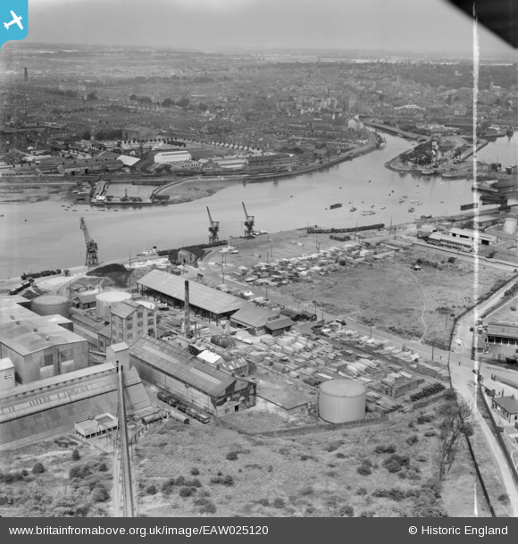
EAW025120 ENGLAND (1949). Gabriel, Wade and English Timber Yard, the River Orwell and the town, Ipswich, from the south-east, 1949. This image was marked by Aerofilms Ltd for photo editing.
© Copyright OpenStreetMap contributors and licensed by the OpenStreetMap Foundation. 2024. Cartography is licensed as CC BY-SA.
Nearby Images (27)
Details
| Title | [EAW025120] Gabriel, Wade and English Timber Yard, the River Orwell and the town, Ipswich, from the south-east, 1949. This image was marked by Aerofilms Ltd for photo editing. |
| Reference | EAW025120 |
| Date | 22-July-1949 |
| Link | |
| Place name | IPSWICH |
| Parish | |
| District | |
| Country | ENGLAND |
| Easting / Northing | 617026, 242753 |
| Longitude / Latitude | 1.1648452916802, 52.040204449245 |
| National Grid Reference | TM170428 |
Pins
Be the first to add a comment to this image!


![[EAW025120] Gabriel, Wade and English Timber Yard, the River Orwell and the town, Ipswich, from the south-east, 1949. This image was marked by Aerofilms Ltd for photo editing.](http://britainfromabove.org.uk/sites/all/libraries/aerofilms-images/public/100x100/EAW/025/EAW025120.jpg)
![[EAW025116] Gabriel, Wade and English Timber Yard and adjacent works on Cliff Quay, Ipswich, from the east, 1949. This image was marked by Aerofilms Ltd for photo editing.](http://britainfromabove.org.uk/sites/all/libraries/aerofilms-images/public/100x100/EAW/025/EAW025116.jpg)
![[EAW025122] Gabriel, Wade and English Timber Yard and environs, Ipswich, from the north, 1949](http://britainfromabove.org.uk/sites/all/libraries/aerofilms-images/public/100x100/EAW/025/EAW025122.jpg)
![[EAW025119] Gabriel, Wade and English Timber Yard, Greenwich Road and environs, Ipswich, 1949. This image was marked by Aerofilms Ltd for photo editing.](http://britainfromabove.org.uk/sites/all/libraries/aerofilms-images/public/100x100/EAW/025/EAW025119.jpg)
![[EPW032847] The docks and town, Ipswich, from the south-east, 1930](http://britainfromabove.org.uk/sites/all/libraries/aerofilms-images/public/100x100/EPW/032/EPW032847.jpg)
![[EPW041402] Gabriel, Wade and English Timber Yard and the Orwell Brick Works on Cliff Quay, Ipswich, 1933](http://britainfromabove.org.uk/sites/all/libraries/aerofilms-images/public/100x100/EPW/041/EPW041402.jpg)
![[EAW025123] Gabriel, Wade and English Timber Yard and environs, Ipswich, 1949](http://britainfromabove.org.uk/sites/all/libraries/aerofilms-images/public/100x100/EAW/025/EAW025123.jpg)
![[EAW025117] Gabriel, Wade and English Timber Yard, Greenwich Road and environs, Ipswich, from the west, 1949](http://britainfromabove.org.uk/sites/all/libraries/aerofilms-images/public/100x100/EAW/025/EAW025117.jpg)
![[EAW045633] Fisons Ltd Cliff Quay Works, Ipswich, 1952. This image was marked by Aerofilms Ltd for photo editing.](http://britainfromabove.org.uk/sites/all/libraries/aerofilms-images/public/100x100/EAW/045/EAW045633.jpg)
![[EAW045631] Fisons Ltd Cliff Quay Works, Ipswich, 1952. This image was marked by Aerofilms Ltd for photo editing.](http://britainfromabove.org.uk/sites/all/libraries/aerofilms-images/public/100x100/EAW/045/EAW045631.jpg)
![[EAW045628] Fisons Ltd Cliff Quay Works, Ipswich, 1952. This image was marked by Aerofilms Ltd for photo editing.](http://britainfromabove.org.uk/sites/all/libraries/aerofilms-images/public/100x100/EAW/045/EAW045628.jpg)
![[EAW025121] Gabriel, Wade and English Timber Yard and the River Orwell looking along Wet Dock, Ipswich, 1949. This image was marked by Aerofilms Ltd for photo editing.](http://britainfromabove.org.uk/sites/all/libraries/aerofilms-images/public/100x100/EAW/025/EAW025121.jpg)
![[EAW045629] Fisons Ltd Cliff Quay Works, Ipswich, 1952. This image was marked by Aerofilms Ltd for photo editing.](http://britainfromabove.org.uk/sites/all/libraries/aerofilms-images/public/100x100/EAW/045/EAW045629.jpg)
![[EAW045630] Fisons Ltd Cliff Quay Works, Ipswich, 1952. This image was marked by Aerofilms Ltd for photo editing.](http://britainfromabove.org.uk/sites/all/libraries/aerofilms-images/public/100x100/EAW/045/EAW045630.jpg)
![[EPW032846] The docks and town, Ipswich, from the south-east, 1930](http://britainfromabove.org.uk/sites/all/libraries/aerofilms-images/public/100x100/EPW/032/EPW032846.jpg)
![[EAW045636] Fisons Ltd Cliff Quay Works, Ipswich, 1952. This image was marked by Aerofilms Ltd for photo editing.](http://britainfromabove.org.uk/sites/all/libraries/aerofilms-images/public/100x100/EAW/045/EAW045636.jpg)
![[EPW032839] The Orwell Brick Works, Ipswich, 1930](http://britainfromabove.org.uk/sites/all/libraries/aerofilms-images/public/100x100/EPW/032/EPW032839.jpg)
![[EPW032831] The docks, Ipswich, from the south-east, 1930](http://britainfromabove.org.uk/sites/all/libraries/aerofilms-images/public/100x100/EPW/032/EPW032831.jpg)
![[EAW045632] Fisons Ltd Cliff Quay Works, Ipswich, 1952](http://britainfromabove.org.uk/sites/all/libraries/aerofilms-images/public/100x100/EAW/045/EAW045632.jpg)
![[EAW025118] orks on Cliff Quay and the Cliff Quay Generating Station, Ipswich, 1949](http://britainfromabove.org.uk/sites/all/libraries/aerofilms-images/public/100x100/EAW/025/EAW025118.jpg)
![[EPW032838] The docks and the town, Ipswich, from the south-east, 1930](http://britainfromabove.org.uk/sites/all/libraries/aerofilms-images/public/100x100/EPW/032/EPW032838.jpg)
![[EAW045635] Fisons Ltd Cliff Quay Works, Ipswich, 1952. This image was marked by Aerofilms Ltd for photo editing.](http://britainfromabove.org.uk/sites/all/libraries/aerofilms-images/public/100x100/EAW/045/EAW045635.jpg)
![[EAW045634] Fisons Ltd Cliff Quay Works, Ipswich, 1952. This image was marked by Aerofilms Ltd for photo editing.](http://britainfromabove.org.uk/sites/all/libraries/aerofilms-images/public/100x100/EAW/045/EAW045634.jpg)
![[EPW043657] Fison, Packard and Prentice at Cliff Quay and environs, Ipswich, from the north-west, 1933. This image has been produced from a damaged negative.](http://britainfromabove.org.uk/sites/all/libraries/aerofilms-images/public/100x100/EPW/043/EPW043657.jpg)
![[EPW032841] The docks, Ipswich, 1930](http://britainfromabove.org.uk/sites/all/libraries/aerofilms-images/public/100x100/EPW/032/EPW032841.jpg)
![[EAW045637] Fisons Ltd Cliff Quay Works, Ipswich, 1952. This image was marked by Aerofilms Ltd for photo editing.](http://britainfromabove.org.uk/sites/all/libraries/aerofilms-images/public/100x100/EAW/045/EAW045637.jpg)
![[EPW032861] The docks and town, Ipswich, from the south-east, 1930](http://britainfromabove.org.uk/sites/all/libraries/aerofilms-images/public/100x100/EPW/032/EPW032861.jpg)