
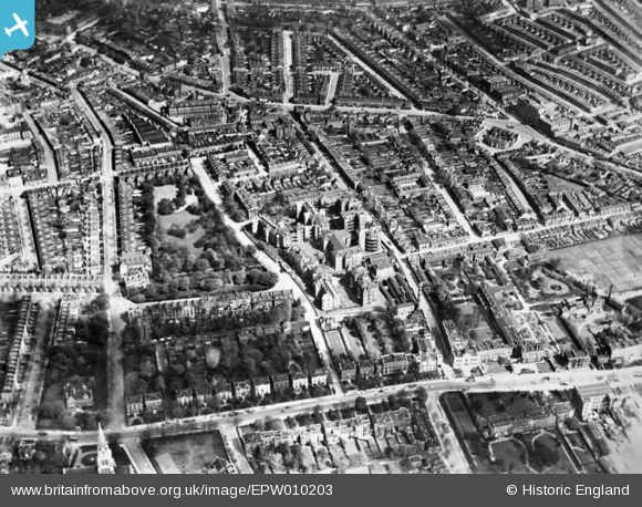
EPW010203 ENGLAND (1924). Brunswick Park and the Camberwell Parish Infirmary (St Giles' Hospital), Camberwell, 1924. This image has been produced from a copy-negative.
© Copyright OpenStreetMap contributors and licensed by the OpenStreetMap Foundation. 2024. Cartography is licensed as CC BY-SA.
Nearby Images (5)
EPW010203
, Camberwell, 1924. This image has been produced from a copy-negative.")
EAW022347

EPW010956

EPW010160

EPW011159

Details
| Title | [EPW010203] Brunswick Park and the Camberwell Parish Infirmary (St Giles' Hospital), Camberwell, 1924. This image has been produced from a copy-negative. |
| Reference | EPW010203 |
| Date | April-1924 |
| Link | |
| Place name | CAMBERWELL |
| Parish | |
| District | |
| Country | ENGLAND |
| Easting / Northing | 533141, 176922 |
| Longitude / Latitude | -0.082675084576578, 51.475085230691 |
| National Grid Reference | TQ331769 |
Pins
 Caryroger |
Friday 20th of May 2022 07:50:45 PM | |
 |
Leslie B |
Sunday 30th of January 2022 06:49:37 PM |
Caryroger |
Thursday 27th of February 2020 02:01:38 PM | |
APR |
Sunday 6th of January 2019 10:42:00 PM | |
APR |
Sunday 6th of January 2019 10:41:11 PM | |
APR |
Sunday 6th of January 2019 10:38:57 PM | |
 |
John |
Monday 20th of February 2017 11:06:30 AM |
My mother spent 3 months there in 1949 and I wasn't allowed to visit her once because I was too young. |
brianbeckett |
Tuesday 30th of June 2020 11:39:42 AM |
Toplotdog |
Monday 25th of May 2015 08:53:55 PM | |
Marco |
Tuesday 6th of January 2015 10:42:50 PM |