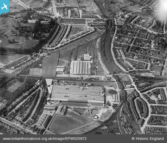
EPW020872 ENGLAND (1928). The Acton and Chiswick Works (London Passenger Transport Board) and environs, Gunnersbury, 1928
© Copyright OpenStreetMap contributors and licensed by the OpenStreetMap Foundation. 2024. Cartography is licensed as CC BY-SA.
Nearby Images (48)
Details
| Title | [EPW020872] The Acton and Chiswick Works (London Passenger Transport Board) and environs, Gunnersbury, 1928 |
| Reference | EPW020872 |
| Date | April-1928 |
| Link | |
| Place name | GUNNERSBURY |
| Parish | |
| District | |
| Country | ENGLAND |
| Easting / Northing | 519671, 178997 |
| Longitude / Latitude | -0.27584946715971, 51.496746653097 |
| National Grid Reference | TQ197790 |


![[EPW020872] The Acton and Chiswick Works (London Passenger Transport Board) and environs, Gunnersbury, 1928](http://britainfromabove.org.uk/sites/all/libraries/aerofilms-images/public/100x100/EPW/020/EPW020872.jpg)
![[EPW043992] The Acton Works (London Passenger Transport Board), Gunnersbury, 1934](http://britainfromabove.org.uk/sites/all/libraries/aerofilms-images/public/100x100/EPW/043/EPW043992.jpg)
![[EPW061230] The London Passenger Transport Board Acton Works, Gunnersbury, 1939. This image has been produced from a damaged negative.](http://britainfromabove.org.uk/sites/all/libraries/aerofilms-images/public/100x100/EPW/061/EPW061230.jpg)
![[EPW020839] The London Electric Railway Co Acton Works, Gunnersbury, 1928](http://britainfromabove.org.uk/sites/all/libraries/aerofilms-images/public/100x100/EPW/020/EPW020839.jpg)
![[EPW020842] The London Electric Railway Co Acton Works, Gunnersbury, 1928](http://britainfromabove.org.uk/sites/all/libraries/aerofilms-images/public/100x100/EPW/020/EPW020842.jpg)
![[EPW020843] The London Electric Railway Co Acton Works, Gunnersbury, 1928](http://britainfromabove.org.uk/sites/all/libraries/aerofilms-images/public/100x100/EPW/020/EPW020843.jpg)
![[EPW020874] The Acton and Chiswick Works (London Passenger Transport Board), Gunnersbury, 1928](http://britainfromabove.org.uk/sites/all/libraries/aerofilms-images/public/100x100/EPW/020/EPW020874.jpg)
![[EPW010686] The Acton (London Passenger Transport) Works, Gunnersbury, 1924](http://britainfromabove.org.uk/sites/all/libraries/aerofilms-images/public/100x100/EPW/010/EPW010686.jpg)
![[EPW010685] The Acton (London Passenger Transport) Works, Gunnersbury, 1924](http://britainfromabove.org.uk/sites/all/libraries/aerofilms-images/public/100x100/EPW/010/EPW010685.jpg)
![[EPW010684] The Acton (London Passenger Transport) Works, Gunnersbury, 1924](http://britainfromabove.org.uk/sites/all/libraries/aerofilms-images/public/100x100/EPW/010/EPW010684.jpg)
![[EPW043993] The Acton Works and the Chiswick Works (London Passenger Transport Board), Gunnersbury, 1934](http://britainfromabove.org.uk/sites/all/libraries/aerofilms-images/public/100x100/EPW/043/EPW043993.jpg)
![[EAW044734] The London Transport Executive Acton Works and Kensington Cemetery, Gunnersbury, 1952. This image was marked by Aerofilms Ltd for photo editing.](http://britainfromabove.org.uk/sites/all/libraries/aerofilms-images/public/100x100/EAW/044/EAW044734.jpg)
![[EAW044728] The London Transport Executive Acton Works, Gunnersbury, 1952. This image was marked by Aerofilms Ltd for photo editing.](http://britainfromabove.org.uk/sites/all/libraries/aerofilms-images/public/100x100/EAW/044/EAW044728.jpg)
![[EPW016535] The Chiswick and Acton (London Passenger Board) Works, Gunnersbury, 1926](http://britainfromabove.org.uk/sites/all/libraries/aerofilms-images/public/100x100/EPW/016/EPW016535.jpg)
![[EPW016537] The Chiswick and Acton (London Passenger Board) Works and environs, Gunnersbury, 1926](http://britainfromabove.org.uk/sites/all/libraries/aerofilms-images/public/100x100/EPW/016/EPW016537.jpg)
![[EPW020838] The London Electric Railway Co Acton Works, Gunnersbury, 1928](http://britainfromabove.org.uk/sites/all/libraries/aerofilms-images/public/100x100/EPW/020/EPW020838.jpg)
![[EPW024941] The Chiswick and Acton (London Passenger Transport Board) Works, Gunnersbury, 1928](http://britainfromabove.org.uk/sites/all/libraries/aerofilms-images/public/100x100/EPW/024/EPW024941.jpg)
![[EAW044727] The London Transport Executive Acton Works, Gunnersbury, 1952. This image was marked by Aerofilms Ltd for photo editing.](http://britainfromabove.org.uk/sites/all/libraries/aerofilms-images/public/100x100/EAW/044/EAW044727.jpg)
![[EPW020840] The London Electric Railway Co Acton Works, Gunnersbury, 1928](http://britainfromabove.org.uk/sites/all/libraries/aerofilms-images/public/100x100/EPW/020/EPW020840.jpg)
![[EPW043995] The Chiswick Works, the Acton Works (London Passenger Transport Board) and South Acton, Gunnersbury, 1934](http://britainfromabove.org.uk/sites/all/libraries/aerofilms-images/public/100x100/EPW/043/EPW043995.jpg)
![[EPW020876] The Acton and Chiswick Works (London Passenger Transport Board) and envions, Gunnersbury, 1928](http://britainfromabove.org.uk/sites/all/libraries/aerofilms-images/public/100x100/EPW/020/EPW020876.jpg)
![[EPW043996] The Chiswick Works, the Acton Works (London Passenger Transport Board) and environs, Gunnersbury, 1934](http://britainfromabove.org.uk/sites/all/libraries/aerofilms-images/public/100x100/EPW/043/EPW043996.jpg)
![[EPW043998] The Chiswick Works, the Acton Works (London Passenger Transport Board) and South Acton, Gunnersbury, 1934](http://britainfromabove.org.uk/sites/all/libraries/aerofilms-images/public/100x100/EPW/043/EPW043998.jpg)
![[EPW020875] The Acton and Chiswick Works (London Passenger Transport Board), Gunnersbury, 1928](http://britainfromabove.org.uk/sites/all/libraries/aerofilms-images/public/100x100/EPW/020/EPW020875.jpg)
![[EAW044733] The London Transport Executive Acton Works and Kensington Cemetery, Gunnersbury, 1952. This image was marked by Aerofilms Ltd for photo editing.](http://britainfromabove.org.uk/sites/all/libraries/aerofilms-images/public/100x100/EAW/044/EAW044733.jpg)
![[EPW020873] The Acton Works (London Passenger Transport Board), Gunnersbury, 1928](http://britainfromabove.org.uk/sites/all/libraries/aerofilms-images/public/100x100/EPW/020/EPW020873.jpg)
![[EPW020871] The Acton Works (London Passenger Transport Board), Gunnersbury, 1928](http://britainfromabove.org.uk/sites/all/libraries/aerofilms-images/public/100x100/EPW/020/EPW020871.jpg)
![[EPW010683] The Acton (London Passenger Transport) Works, Gunnersbury, 1924](http://britainfromabove.org.uk/sites/all/libraries/aerofilms-images/public/100x100/EPW/010/EPW010683.jpg)
![[EAW044725] The London Transport Executive Acton Works and Gunnersbury Park, Gunnersbury, 1952. This image was marked by Aerofilms Ltd for photo editing.](http://britainfromabove.org.uk/sites/all/libraries/aerofilms-images/public/100x100/EAW/044/EAW044725.jpg)
![[EPW016538] The Chiswick and Acton (London Passenger Board) Works and environs, Gunnersbury, 1926](http://britainfromabove.org.uk/sites/all/libraries/aerofilms-images/public/100x100/EPW/016/EPW016538.jpg)
![[EAW044735] The London Transport Executive Acton Works, Gunnersbury, 1952. This image was marked by Aerofilms Ltd for photo editing.](http://britainfromabove.org.uk/sites/all/libraries/aerofilms-images/public/100x100/EAW/044/EAW044735.jpg)
![[EAW044732] The London Transport Executive Acton Works, Gunnersbury, 1952. This image was marked by Aerofilms Ltd for photo editing.](http://britainfromabove.org.uk/sites/all/libraries/aerofilms-images/public/100x100/EAW/044/EAW044732.jpg)
![[EPW016536] The Chiswick and Acton (London Passenger Board) Works and environs, Gunnersbury, 1926](http://britainfromabove.org.uk/sites/all/libraries/aerofilms-images/public/100x100/EPW/016/EPW016536.jpg)
![[EAW044736] The London Transport Executive Acton Works, Kensington Cemetery and Gunnersbury Park, Gunnersbury, 1952. This image was marked by Aerofilms Ltd for photo editing.](http://britainfromabove.org.uk/sites/all/libraries/aerofilms-images/public/100x100/EAW/044/EAW044736.jpg)
![[EPW007145] Chiswick Works (London Passenger Transport Works) and environs, Gunnersbury, from the north-east, 1921](http://britainfromabove.org.uk/sites/all/libraries/aerofilms-images/public/100x100/EPW/007/EPW007145.jpg)
![[EAW044731] The London Transport Executive Acton Works and South Acton, Gunnersbury, 1952. This image was marked by Aerofilms Ltd for photo editing.](http://britainfromabove.org.uk/sites/all/libraries/aerofilms-images/public/100x100/EAW/044/EAW044731.jpg)
![[EPW010674] The Chiswick and Acton (London Passenger Transport) Works, Gunnersbury, 1924](http://britainfromabove.org.uk/sites/all/libraries/aerofilms-images/public/100x100/EPW/010/EPW010674.jpg)
![[EPW005268] Chiswick Works, London Passenger Transport Board building, Gunnersbury, 1921](http://britainfromabove.org.uk/sites/all/libraries/aerofilms-images/public/100x100/EPW/005/EPW005268.jpg)
![[EAW044724] The London Transport Executive Acton Works and Gunnersbury Park, Gunnersbury, 1952. This image was marked by Aerofilms Ltd for photo editing.](http://britainfromabove.org.uk/sites/all/libraries/aerofilms-images/public/100x100/EAW/044/EAW044724.jpg)
![[EAW044726] The London Transport Executive Acton Works and South Acton, Gunnersbury, 1952. This image was marked by Aerofilms Ltd for photo editing.](http://britainfromabove.org.uk/sites/all/libraries/aerofilms-images/public/100x100/EAW/044/EAW044726.jpg)
![[EAW044730] The London Transport Executive Acton Works and Kensington Cemetery, Gunnersbury, 1952. This image was marked by Aerofilms Ltd for photo editing.](http://britainfromabove.org.uk/sites/all/libraries/aerofilms-images/public/100x100/EAW/044/EAW044730.jpg)
![[EPW010675] The Chiswick and Acton (London Passenger Transport) Works, Gunnersbury, 1924](http://britainfromabove.org.uk/sites/all/libraries/aerofilms-images/public/100x100/EPW/010/EPW010675.jpg)
![[EPW005267] Chiswick Works, London Passenger Transport Board building, Gunnersbury, 1921](http://britainfromabove.org.uk/sites/all/libraries/aerofilms-images/public/100x100/EPW/005/EPW005267.jpg)
![[EAW044729] The London Transport Executive Acton Works and Gunnersbury Park, Gunnersbury, 1952. This image was marked by Aerofilms Ltd for photo editing.](http://britainfromabove.org.uk/sites/all/libraries/aerofilms-images/public/100x100/EAW/044/EAW044729.jpg)
![[EPW043999] The Chiswick Works, the Acton Works (London Passenger Transport Board) and South Acton, Gunnersbury, 1934](http://britainfromabove.org.uk/sites/all/libraries/aerofilms-images/public/100x100/EPW/043/EPW043999.jpg)
![[EPW021261] The London Passenger Transport Board Chiswick Works and Acton Works and environs, Gunnersbury, from the south-west, 1928](http://britainfromabove.org.uk/sites/all/libraries/aerofilms-images/public/100x100/EPW/021/EPW021261.jpg)
![[EPW005261] Chiswick Works, London Passenger Transport Board building, Gunnersbury, 1921](http://britainfromabove.org.uk/sites/all/libraries/aerofilms-images/public/100x100/EPW/005/EPW005261.jpg)
![[EPW043997] The Chiswick Works, the Acton Works (London Passenger Transport Board) and environs, Gunnersbury, 1934](http://britainfromabove.org.uk/sites/all/libraries/aerofilms-images/public/100x100/EPW/043/EPW043997.jpg)
