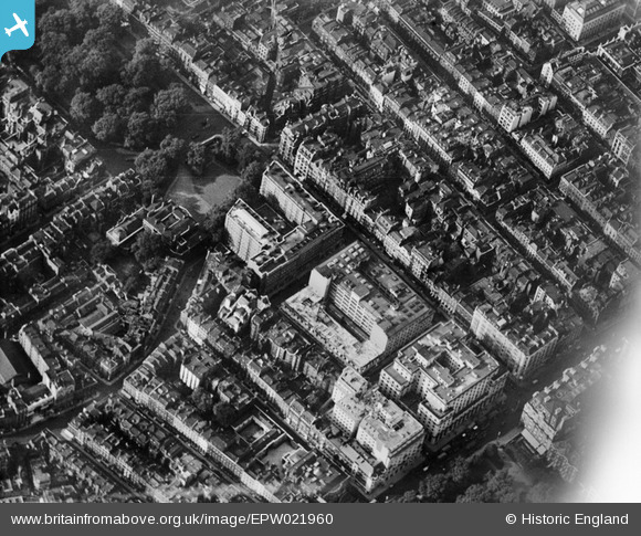
EPW021960 ENGLAND (1928). Devonshire House and surroundings, Westminster, 1928
© Copyright OpenStreetMap contributors and licensed by the OpenStreetMap Foundation. 2024. Cartography is licensed as CC BY-SA.
Nearby Images (23)
Details
| Title | [EPW021960] Devonshire House and surroundings, Westminster, 1928 |
| Reference | EPW021960 |
| Date | July-1928 |
| Link | |
| Place name | WESTMINSTER |
| Parish | |
| District | |
| Country | ENGLAND |
| Easting / Northing | 528917, 180437 |
| Longitude / Latitude | -0.1421846807308, 51.507655810492 |
| National Grid Reference | TQ289804 |
Pins
 Class31 |
Thursday 21st of May 2015 06:59:12 PM | |
 Class31 |
Thursday 21st of May 2015 06:58:32 PM | |
 Class31 |
Thursday 21st of May 2015 06:56:13 PM | |
 Class31 |
Thursday 21st of May 2015 06:54:49 PM | |
 Class31 |
Thursday 21st of May 2015 06:52:29 PM | |
 Alan McFaden |
Friday 5th of July 2013 12:23:00 PM | |
 Alan McFaden |
Friday 5th of July 2013 12:22:31 PM | |
 Alan McFaden |
Friday 5th of July 2013 12:22:04 PM |


![[EPW021960] Devonshire House and surroundings, Westminster, 1928](http://britainfromabove.org.uk/sites/all/libraries/aerofilms-images/public/100x100/EPW/021/EPW021960.jpg)
![[EPW021881] Piccadilly, Westminster, 1928](http://britainfromabove.org.uk/sites/all/libraries/aerofilms-images/public/100x100/EPW/021/EPW021881.jpg)
![[EPW021959] Devonshire House and surroundings, Westminster, 1928](http://britainfromabove.org.uk/sites/all/libraries/aerofilms-images/public/100x100/EPW/021/EPW021959.jpg)
![[EPW021956] Devonshire House and surroundings, Westminster, 1928. This image has been produced from a print.](http://britainfromabove.org.uk/sites/all/libraries/aerofilms-images/public/100x100/EPW/021/EPW021956.jpg)
![[EPW021958] Berkley Street and environs, Westminster, 1928. This image has been produced from a print.](http://britainfromabove.org.uk/sites/all/libraries/aerofilms-images/public/100x100/EPW/021/EPW021958.jpg)
![[EPW021975] Devonshire House and surroundings, Westminster, 1928](http://britainfromabove.org.uk/sites/all/libraries/aerofilms-images/public/100x100/EPW/021/EPW021975.jpg)
![[EPW009097] View of Piccadilly and environs, Westminster, from the west, 1923](http://britainfromabove.org.uk/sites/all/libraries/aerofilms-images/public/100x100/EPW/009/EPW009097.jpg)
![[EPW021955] Devonshire House and surroundings, Westminster, 1928](http://britainfromabove.org.uk/sites/all/libraries/aerofilms-images/public/100x100/EPW/021/EPW021955.jpg)
![[EPW046659] Buckingham Palace and the surrounding parks and city, Westminster, from the south-west, 1935](http://britainfromabove.org.uk/sites/all/libraries/aerofilms-images/public/100x100/EPW/046/EPW046659.jpg)
![[EPW030070] The R101 airship on its first test flight, Westminster, from the west, 1929](http://britainfromabove.org.uk/sites/all/libraries/aerofilms-images/public/100x100/EPW/030/EPW030070.jpg)
![[EPW021957] Devonshire House and surroundings, Westminster, 1928. This image has been produced from a print affected by flare.](http://britainfromabove.org.uk/sites/all/libraries/aerofilms-images/public/100x100/EPW/021/EPW021957.jpg)
![[EAW048538] A cityscape over central London to show the procession route for the Coronation of Queen Elizabeth II, Westminster, 1953](http://britainfromabove.org.uk/sites/all/libraries/aerofilms-images/public/100x100/EAW/048/EAW048538.jpg)
![[EPW020947] Piccadilly and Green Park, St James, 1928](http://britainfromabove.org.uk/sites/all/libraries/aerofilms-images/public/100x100/EPW/020/EPW020947.jpg)
![[EPW011932] Mayfair and St James's, St James, 1924. This image has been produced from a print.](http://britainfromabove.org.uk/sites/all/libraries/aerofilms-images/public/100x100/EPW/011/EPW011932.jpg)
![[EPW046649] Regent Street and environs, Soho, from the west, 1935](http://britainfromabove.org.uk/sites/all/libraries/aerofilms-images/public/100x100/EPW/046/EPW046649.jpg)
![[EPW060560] The new Air Ministry building on Berkeley Square and environs, Mayfair, 1939](http://britainfromabove.org.uk/sites/all/libraries/aerofilms-images/public/100x100/EPW/060/EPW060560.jpg)
![[EPW060558] The new Air Ministry building on Berkeley Square and environs, Mayfair, 1939](http://britainfromabove.org.uk/sites/all/libraries/aerofilms-images/public/100x100/EPW/060/EPW060558.jpg)
![[EPW060761] Central London from Grosvenor Square to St Paul's Cathderal, Westminster, from the west, 1939](http://britainfromabove.org.uk/sites/all/libraries/aerofilms-images/public/100x100/EPW/060/EPW060761.jpg)
![[EPW061245] St James's Park and Westminster, St James, from the north-west, 1939](http://britainfromabove.org.uk/sites/all/libraries/aerofilms-images/public/100x100/EPW/061/EPW061245.jpg)
![[EAW048536] A cityscape over central London to show the procession route for the Coronation of Queen Elizabeth II, Westminster, 1953](http://britainfromabove.org.uk/sites/all/libraries/aerofilms-images/public/100x100/EAW/048/EAW048536.jpg)
![[EPW039583] Regent Street, Piccadilly and environs, Westminster, from the west, 1932](http://britainfromabove.org.uk/sites/all/libraries/aerofilms-images/public/100x100/EPW/039/EPW039583.jpg)
![[EAW000488] Hyde Park, Park Lane and environs, Westminster, from the east, 1946](http://britainfromabove.org.uk/sites/all/libraries/aerofilms-images/public/100x100/EAW/000/EAW000488.jpg)
![[EAW000484] Burlington House and environs, Westminster, 1946](http://britainfromabove.org.uk/sites/all/libraries/aerofilms-images/public/100x100/EAW/000/EAW000484.jpg)


