
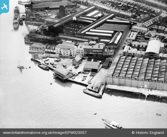
EPW023057 ENGLAND (1928). Engineering and Boatbuilding Works at Thetis Wharf, Cowes, 1928
© Copyright OpenStreetMap contributors and licensed by the OpenStreetMap Foundation. 2024. Cartography is licensed as CC BY-SA.
Nearby Images (2)
EPW023057

EPW039663

Details
| Title | [EPW023057] Engineering and Boatbuilding Works at Thetis Wharf, Cowes, 1928 |
| Reference | EPW023057 |
| Date | August-1928 |
| Link | |
| Place name | COWES |
| Parish | COWES |
| District | |
| Country | ENGLAND |
| Easting / Northing | 449967, 95668 |
| Longitude / Latitude | -1.2915199761807, 50.75788419178 |
| National Grid Reference | SZ500957 |
Pins
 Sparky |
Wednesday 9th of August 2017 08:14:18 AM | |
Probably not WW2 camouflage. Photo date is 1928.... |
Seattle Man |
Thursday 17th of December 2020 12:33:15 PM |
wessexpig |
Monday 17th of June 2013 08:52:52 PM | |
steve |
Sunday 13th of January 2013 07:35:22 PM | |
IOWBRIAN |
Wednesday 19th of September 2012 03:30:20 PM |
User Comment Contributions
THE ABOVE PHOTO SHOWS JOHN SAMUEL WHITES SHIPYARD THAT CLOSED CIRCA 1968. IN BOTH THE WORLD WARD THIS YARD BULIT AROUND 25 NAVAL FRIGATES. IN THE FIRST WORLD WAR IT ALSO MADE AIRCRAFT AND ONE SUBMARINE. |
IOWBRIAN |
Tuesday 2nd of October 2012 02:17:19 PM |
Dear IOWBRIAN, thank you very much for your interesting comments and for sharing your knowledge with other users! This is exactly what we're looking for! Thanks again, Alexander Treliving (Britain from Above Cataloguer, EH) |
Alexander J Treliving |
Tuesday 2nd of October 2012 02:17:19 PM |