
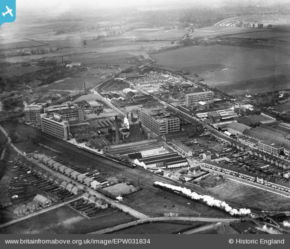
EPW031834 ENGLAND (1930). Gramophone Company (HMV) factory buildings and environs, Hayes, from the south-east, 1930
© Copyright OpenStreetMap contributors and licensed by the OpenStreetMap Foundation. 2024. Cartography is licensed as CC BY-SA.
Nearby Images (22)
EPW031834
 factory buildings and environs, Hayes, from the south-east, 1930")
EPW031821
 factory buildings and environs, Hayes, 1930")
EPW031820
 factory buildings and environs, Hayes, 1930")
EPW031819
 factory buildings and environs, Hayes, 1930")
EPW008026

EPW037590

EPW008027

EPW031817
 factory buildings and environs, Hayes, 1930")
EPW005151

EPW031839
 factory buildings and environs, Hayes, 1930")
EPW015337

EPW031822
 factory buildings and environs, Hayes, from the south, 1930")
EPW031818
 factory buildings and environs, Hayes, 1930")
EPW015336

EPW031823
 factory buildings and environs, Hayes, 1930")
EPW008028

EPW005150

EPW037573

EPW031825
 factory buildings and environs, Hayes, 1930")
EPW037589

EPW031824
 factory buildings and environs, Hayes, 1930")
EPW031837
 factory buildings and environs, Hayes, from the south-east, 1930")
Details
| Title | [EPW031834] Gramophone Company (HMV) factory buildings and environs, Hayes, from the south-east, 1930 |
| Reference | EPW031834 |
| Date | 7-May-1930 |
| Link | |
| Place name | HAYES |
| Parish | |
| District | |
| Country | ENGLAND |
| Easting / Northing | 509431, 179454 |
| Longitude / Latitude | -0.42317677609475, 51.502930172316 |
| National Grid Reference | TQ094795 |
Pins
Be the first to add a comment to this image!