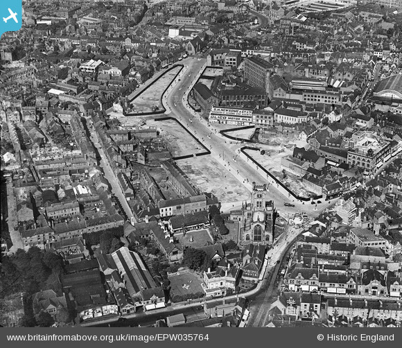
EPW035764 ENGLAND (1931). Corporation Street, St John the Baptist's Church and environs, Coventry, 1931
© Copyright OpenStreetMap contributors and licensed by the OpenStreetMap Foundation. 2024. Cartography is licensed as CC BY-SA.
Nearby Images (34)
Details
| Title | [EPW035764] Corporation Street, St John the Baptist's Church and environs, Coventry, 1931 |
| Reference | EPW035764 |
| Date | 1-July-1931 |
| Link | |
| Place name | COVENTRY |
| Parish | |
| District | |
| Country | ENGLAND |
| Easting / Northing | 433124, 279155 |
| Longitude / Latitude | -1.5129995369203, 52.409017547545 |
| National Grid Reference | SP331792 |


![[EPW035764] Corporation Street, St John the Baptist's Church and environs, Coventry, 1931](http://britainfromabove.org.uk/sites/all/libraries/aerofilms-images/public/100x100/EPW/035/EPW035764.jpg)
![[EPW035765] Corporation Street and environs, Coventry, 1931](http://britainfromabove.org.uk/sites/all/libraries/aerofilms-images/public/100x100/EPW/035/EPW035765.jpg)
![[EPW035763] Corporation Street, the Rover Engineering Works and environs, Coventry, 1931](http://britainfromabove.org.uk/sites/all/libraries/aerofilms-images/public/100x100/EPW/035/EPW035763.jpg)
![[EPW001202] The city centre, Coventry, from the north-west, 1920](http://britainfromabove.org.uk/sites/all/libraries/aerofilms-images/public/100x100/EPW/001/EPW001202.jpg)
![[EAW024997] The Leigh Worsted Mill and the Gas Street Gas Works, Coventry, from the south-east, 1949. This image was marked by Aerofilms Ltd for photo editing.](http://britainfromabove.org.uk/sites/all/libraries/aerofilms-images/public/100x100/EAW/024/EAW024997.jpg)
![[EAW024994] The Leigh Worsted Mill and the city centre, Coventry, 1949. This image was marked by Aerofilms Ltd for photo editing.](http://britainfromabove.org.uk/sites/all/libraries/aerofilms-images/public/100x100/EAW/024/EAW024994.jpg)
![[EPW035762] Corporation Street and environs, Coventry, 1931](http://britainfromabove.org.uk/sites/all/libraries/aerofilms-images/public/100x100/EPW/035/EPW035762.jpg)
![[EAW001832] Barrack Square Market, Corporation Street and the bomb damaged city centre, Coventry, 1946](http://britainfromabove.org.uk/sites/all/libraries/aerofilms-images/public/100x100/EAW/001/EAW001832.jpg)
![[EAW024990] The Leigh Worsted Mill, Coventry, 1949. This image was marked by Aerofilms Ltd for photo editing.](http://britainfromabove.org.uk/sites/all/libraries/aerofilms-images/public/100x100/EAW/024/EAW024990.jpg)
![[EAW031592] Leigh Worsteds Mills, Coventry, 1950. This image was marked by Aerofilms Ltd for photo editing.](http://britainfromabove.org.uk/sites/all/libraries/aerofilms-images/public/100x100/EAW/031/EAW031592.jpg)
![[EAW030280] The city centre, Coventry, 1950](http://britainfromabove.org.uk/sites/all/libraries/aerofilms-images/public/100x100/EAW/030/EAW030280.jpg)
![[EPW001199] Coventry city centre, Coventry, 1920](http://britainfromabove.org.uk/sites/all/libraries/aerofilms-images/public/100x100/EPW/001/EPW001199.jpg)
![[EAW024991] The city centre, Coventry, from the north-west, 1949](http://britainfromabove.org.uk/sites/all/libraries/aerofilms-images/public/100x100/EAW/024/EAW024991.jpg)
![[EAW001834] The bomb damaged city centre, Coventry, 1946](http://britainfromabove.org.uk/sites/all/libraries/aerofilms-images/public/100x100/EAW/001/EAW001834.jpg)
![[EAW031596] Leigh Worsteds Mills and environs, Coventry, 1950. This image was marked by Aerofilms Ltd for photo editing.](http://britainfromabove.org.uk/sites/all/libraries/aerofilms-images/public/100x100/EAW/031/EAW031596.jpg)
![[EAW031595] Leigh Worsteds Mills, Coventry, 1950. This image was marked by Aerofilms Ltd for photo editing.](http://britainfromabove.org.uk/sites/all/libraries/aerofilms-images/public/100x100/EAW/031/EAW031595.jpg)
![[EAW031593] Leigh Worsteds Mills, Coventry, 1950. This image was marked by Aerofilms Ltd for photo editing.](http://britainfromabove.org.uk/sites/all/libraries/aerofilms-images/public/100x100/EAW/031/EAW031593.jpg)
![[EAW024989] The Leigh Worsted Mill, Coventry, 1949. This image was marked by Aerofilms Ltd for photo editing.](http://britainfromabove.org.uk/sites/all/libraries/aerofilms-images/public/100x100/EAW/024/EAW024989.jpg)
![[EAW025001] The Leigh Worsted Mill and the city centre, Coventry, from the north, 1949. This image has been produced from a print marked by Aerofilms Ltd for photo editing.](http://britainfromabove.org.uk/sites/all/libraries/aerofilms-images/public/100x100/EAW/025/EAW025001.jpg)
![[EAW031597] Leigh Worsteds Mills, Coventry, 1950. This image was marked by Aerofilms Ltd for photo editing.](http://britainfromabove.org.uk/sites/all/libraries/aerofilms-images/public/100x100/EAW/031/EAW031597.jpg)
![[EAW031594] Leigh Worsteds Mills, Coventry, 1950. This image was marked by Aerofilms Ltd for photo editing.](http://britainfromabove.org.uk/sites/all/libraries/aerofilms-images/public/100x100/EAW/031/EAW031594.jpg)
![[EAW024993] The Leigh Worsted Mill, Coventry, 1949. This image was marked by Aerofilms Ltd for photo editing.](http://britainfromabove.org.uk/sites/all/libraries/aerofilms-images/public/100x100/EAW/024/EAW024993.jpg)
![[EAW024998] The Leigh Worsted Mill, Coventry, 1949](http://britainfromabove.org.uk/sites/all/libraries/aerofilms-images/public/100x100/EAW/024/EAW024998.jpg)
![[EAW001828] Corporation Street and Cross Cheaping, Coventry, 1946](http://britainfromabove.org.uk/sites/all/libraries/aerofilms-images/public/100x100/EAW/001/EAW001828.jpg)
![[EAW024999] The Leigh Worsted Mill, Coventry, from the west, 1949. This image has been produced from a damaged negative.](http://britainfromabove.org.uk/sites/all/libraries/aerofilms-images/public/100x100/EAW/024/EAW024999.jpg)
![[EPW053103] The city centre, Coventry, 1937](http://britainfromabove.org.uk/sites/all/libraries/aerofilms-images/public/100x100/EPW/053/EPW053103.jpg)
![[EPW061105] Spon Street, Hill Street and environs, Coventry, 1939](http://britainfromabove.org.uk/sites/all/libraries/aerofilms-images/public/100x100/EPW/061/EPW061105.jpg)
![[EAW025000] The Leigh Worsted Mill and the city centre, Coventry, from the north-west, 1949. This image has been produced from a print.](http://britainfromabove.org.uk/sites/all/libraries/aerofilms-images/public/100x100/EAW/025/EAW025000.jpg)
![[EPW047173] The A C Wickman Ltd Engineering Works and the city centre, Coventry, 1935](http://britainfromabove.org.uk/sites/all/libraries/aerofilms-images/public/100x100/EPW/047/EPW047173.jpg)
![[EAW024996] The Tudor Rose Public House and Corporation Street, Coventry, 1949](http://britainfromabove.org.uk/sites/all/libraries/aerofilms-images/public/100x100/EAW/024/EAW024996.jpg)
![[EAW024992] The Leigh Worsted Mill, Coventry, 1949. This image was marked by Aerofilms Ltd for photo editing.](http://britainfromabove.org.uk/sites/all/libraries/aerofilms-images/public/100x100/EAW/024/EAW024992.jpg)
![[EAW025002] The Leigh Worsted Mill and environs, Coventry, 1949. This image has been produced from a print marked by Aerofilms Ltd for photo editing.](http://britainfromabove.org.uk/sites/all/libraries/aerofilms-images/public/100x100/EAW/025/EAW025002.jpg)
![[EPW061111] The city centre, Coventry, 1939](http://britainfromabove.org.uk/sites/all/libraries/aerofilms-images/public/100x100/EPW/061/EPW061111.jpg)
![[EAW051852] Broadgate and the city centre, Coventry, 1953](http://britainfromabove.org.uk/sites/all/libraries/aerofilms-images/public/100x100/EAW/051/EAW051852.jpg)


